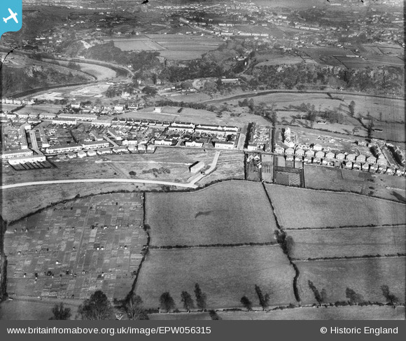
EPW056315 ENGLAND (1938). Fermaine Avenue, Broomhill Road and environs, Broom Hill, 1938
© Copyright OpenStreetMap contributors and licensed by the OpenStreetMap Foundation. 2024. Cartography is licensed as CC BY-SA.
Nearby Images (11)
Details
| Title | [EPW056315] Fermaine Avenue, Broomhill Road and environs, Broom Hill, 1938 |
| Reference | EPW056315 |
| Date | 24-January-1938 |
| Link | |
| Place name | BROOM HILL |
| Parish | |
| District | |
| Country | ENGLAND |
| Easting / Northing | 362686, 171388 |
| Longitude / Latitude | -2.5369129051438, 51.439765849017 |
| National Grid Reference | ST627714 |
Pins
Be the first to add a comment to this image!


![[EPW056315] Fermaine Avenue, Broomhill Road and environs, Broom Hill, 1938](http://britainfromabove.org.uk/sites/all/libraries/aerofilms-images/public/100x100/EPW/056/EPW056315.jpg)
![[EPW056311] Birchwood Road, the River Avon and environs, Broom Hill, from the south, 1938](http://britainfromabove.org.uk/sites/all/libraries/aerofilms-images/public/100x100/EPW/056/EPW056311.jpg)
![[EPW056302] Allison Road and environs, Broom Hill, 1938](http://britainfromabove.org.uk/sites/all/libraries/aerofilms-images/public/100x100/EPW/056/EPW056302.jpg)
![[EPW056314] Allison Road, Broomhill Road and environs, Broom Hill, 1938](http://britainfromabove.org.uk/sites/all/libraries/aerofilms-images/public/100x100/EPW/056/EPW056314.jpg)
![[EPW056313] Broom Hill, Brislington, from the south-west, 1938](http://britainfromabove.org.uk/sites/all/libraries/aerofilms-images/public/100x100/EPW/056/EPW056313.jpg)
![[EPW056306] Broom Hill, Brislington, from the south-west, 1938](http://britainfromabove.org.uk/sites/all/libraries/aerofilms-images/public/100x100/EPW/056/EPW056306.jpg)
![[EPW056301] Broom Hill, Brislington, from the south-west, 1938](http://britainfromabove.org.uk/sites/all/libraries/aerofilms-images/public/100x100/EPW/056/EPW056301.jpg)
![[EPW056309] Broom Hill, Brislington, from the south-west, 1938](http://britainfromabove.org.uk/sites/all/libraries/aerofilms-images/public/100x100/EPW/056/EPW056309.jpg)
![[EPW056304] Broom Hill, Brislington, from the south-west, 1938](http://britainfromabove.org.uk/sites/all/libraries/aerofilms-images/public/100x100/EPW/056/EPW056304.jpg)
![[EPW056310] Broom Hill, Brislington, from the south-west, 1938](http://britainfromabove.org.uk/sites/all/libraries/aerofilms-images/public/100x100/EPW/056/EPW056310.jpg)
![[EPW056303] Allison Road and environs, Broom Hill, 1938](http://britainfromabove.org.uk/sites/all/libraries/aerofilms-images/public/100x100/EPW/056/EPW056303.jpg)