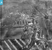
EPW056264 ENGLAND (1938). High Road and environs, Wembley, 1938
© Copyright OpenStreetMap contributors and licensed by the OpenStreetMap Foundation. 2026. Cartography is licensed as CC BY-SA.
Nearby Images (6)
Details
| Title | [EPW056264] High Road and environs, Wembley, 1938 |
| Reference | EPW056264 |
| Date | 17-January-1938 |
| Link | |
| Place name | WEMBLEY |
| Parish | |
| District | |
| Country | ENGLAND |
| Easting / Northing | 518576, 185163 |
| Longitude / Latitude | -0.28954216659582, 51.552400307579 |
| National Grid Reference | TQ186852 |
Pins

Class31 |
Saturday 29th of November 2014 12:12:34 PM | |

Class31 |
Saturday 29th of November 2014 12:11:52 PM | |

Wilmington |
Friday 21st of February 2014 04:50:43 AM | |

Mrs Incredible |
Sunday 7th of July 2013 11:32:56 PM | |
Sorry to say, but the theatre you refer to was the "Wembley Hall," the "Majestic" (theatre & ball-room) was further along the High Road next to the P.O. opp. Park Lane. |

Wilmington |
Thursday 16th of January 2014 12:26:09 PM |

Mrs Incredible |
Sunday 7th of July 2013 11:32:06 PM | |
For further information see page 37 of "Memories of Wembley"......hope you can hang on! |

Wilmington |
Tuesday 5th of November 2013 01:51:16 AM |
User Comment Contributions
The Triangle, Wembley, 07/10/2014 |

Class31 |
Saturday 29th of November 2014 12:10:52 PM |

classicforever |
Saturday 3rd of August 2013 08:29:05 AM |


![[EPW056264] High Road and environs, Wembley, 1938](http://britainfromabove.org.uk/sites/all/libraries/aerofilms-images/public/100x100/EPW/056/EPW056264.jpg)
![[EPW056263] Wesleyan Methodist Church on Park Lane, the Majestic Theatre and High Road, Wembley, 1938](http://britainfromabove.org.uk/sites/all/libraries/aerofilms-images/public/100x100/EPW/056/EPW056263.jpg)
![[EPW056262] Athletic ground off London Road, High Road and environs, Wembley, 1938](http://britainfromabove.org.uk/sites/all/libraries/aerofilms-images/public/100x100/EPW/056/EPW056262.jpg)
![[EPW054286] An infrared photograph over Wembley and Brent towards Hendon, Wembley, from the south-west, 1937](http://britainfromabove.org.uk/sites/all/libraries/aerofilms-images/public/100x100/EPW/054/EPW054286.jpg)
![[EPW056261] Athletic ground off London Road, High Road and environs, Wembley, from the south-east, 1938](http://britainfromabove.org.uk/sites/all/libraries/aerofilms-images/public/100x100/EPW/056/EPW056261.jpg)
![[EPW056259] High Road and environs, Wembley, 1938. This image has been produced from a copy-negative.](http://britainfromabove.org.uk/sites/all/libraries/aerofilms-images/public/100x100/EPW/056/EPW056259.jpg)
