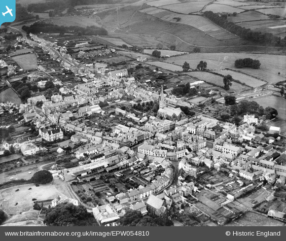
EPW054810 ENGLAND (1937). The town, Great Torrington, 1937
© Copyright OpenStreetMap contributors and licensed by the OpenStreetMap Foundation. 2025. Cartography is licensed as CC BY-SA.
Nearby Images (7)
Details
| Title | [EPW054810] The town, Great Torrington, 1937 |
| Reference | EPW054810 |
| Date | August-1937 |
| Link | |
| Place name | GREAT TORRINGTON |
| Parish | GREAT TORRINGTON |
| District | |
| Country | ENGLAND |
| Easting / Northing | 249479, 119171 |
| Longitude / Latitude | -4.1431888631841, 50.951743588732 |
| National Grid Reference | SS495192 |
Pins

Adders |
Sunday 5th of January 2025 01:51:03 PM |


![[EPW054810] The town, Great Torrington, 1937](http://britainfromabove.org.uk/sites/all/libraries/aerofilms-images/public/100x100/EPW/054/EPW054810.jpg)
![[EPW054813] The town centre, Great Torrington, 1937](http://britainfromabove.org.uk/sites/all/libraries/aerofilms-images/public/100x100/EPW/054/EPW054813.jpg)
![[EPW054811] St Michael and All Angels Church and the town centre, Great Torrington, 1937](http://britainfromabove.org.uk/sites/all/libraries/aerofilms-images/public/100x100/EPW/054/EPW054811.jpg)
![[EPW033169] The town centre, Great Torrington, 1930. This image has been produced from a print.](http://britainfromabove.org.uk/sites/all/libraries/aerofilms-images/public/100x100/EPW/033/EPW033169.jpg)
![[EPW033170] The town centre, Great Torrington, 1930](http://britainfromabove.org.uk/sites/all/libraries/aerofilms-images/public/100x100/EPW/033/EPW033170.jpg)
![[EPW033168] The town centre, Great Torrington, 1930. This image has been produced from a print.](http://britainfromabove.org.uk/sites/all/libraries/aerofilms-images/public/100x100/EPW/033/EPW033168.jpg)
![[EPW054812] The town, Great Torrington, from the south, 1937](http://britainfromabove.org.uk/sites/all/libraries/aerofilms-images/public/100x100/EPW/054/EPW054812.jpg)