
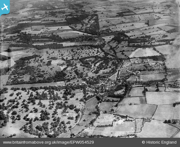
EPW054529 ENGLAND (1937). The village and surrounding countryside, Welwyn, 1937
© Copyright OpenStreetMap contributors and licensed by the OpenStreetMap Foundation. 2026. Cartography is licensed as CC BY-SA.
Nearby Images (3)
EPW054529

EPW054530

EPW054512

Details
| Title | [EPW054529] The village and surrounding countryside, Welwyn, 1937 |
| Reference | EPW054529 |
| Date | 30-July-1937 |
| Link | |
| Place name | WELWYN |
| Parish | WELWYN |
| District | |
| Country | ENGLAND |
| Easting / Northing | 523631, 216004 |
| Longitude / Latitude | -0.20573161960992, 51.828508689265 |
| National Grid Reference | TL236160 |
Pins

Wolfie |
Thursday 22nd of February 2024 08:20:15 PM | |

John |
Thursday 11th of February 2021 05:50:09 PM | |
|
Chells809 |
Thursday 2nd of January 2014 09:40:47 PM | |
|
Chells809 |
Thursday 2nd of January 2014 09:38:48 PM | |
|
Chells809 |
Thursday 2nd of January 2014 09:38:18 PM | |
|
Chells809 |
Thursday 2nd of January 2014 09:37:25 PM | |
|
Chells809 |
Thursday 2nd of January 2014 09:36:20 PM | |
|
Chells809 |
Thursday 2nd of January 2014 09:35:21 PM | |
|
Chells809 |
Thursday 2nd of January 2014 09:34:19 PM | |
|
Norman Lucey |
Thursday 31st of October 2013 04:57:40 PM | |
|
Norman Lucey |
Thursday 31st of October 2013 04:57:00 PM | |
|
NAM2505 |
Sunday 23rd of June 2013 04:53:46 AM | |
|
NAM2505 |
Sunday 23rd of June 2013 04:52:52 AM | |
|
NAM2505 |
Sunday 23rd of June 2013 04:52:33 AM |