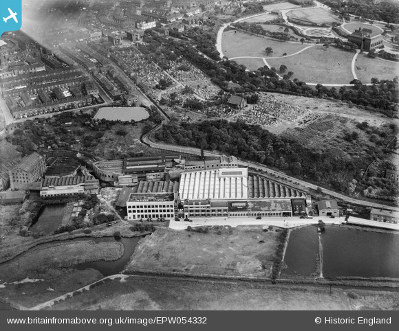
EPW054332 ENGLAND (1937). The Hendham Vale Works, the Manchester General Cemetery and Queen's Park, Harpurhey, 1937. This image has been affected by flare.
© Copyright OpenStreetMap contributors and licensed by the OpenStreetMap Foundation. 2026. Cartography is licensed as CC BY-SA.
Nearby Images (40)
Details
| Title | [EPW054332] The Hendham Vale Works, the Manchester General Cemetery and Queen's Park, Harpurhey, 1937. This image has been affected by flare. |
| Reference | EPW054332 |
| Date | 20-July-1937 |
| Link | |
| Place name | HARPURHEY |
| Parish | |
| District | |
| Country | ENGLAND |
| Easting / Northing | 385369, 401188 |
| Longitude / Latitude | -2.2206279678885, 53.506927871543 |
| National Grid Reference | SD854012 |
Pins
Be the first to add a comment to this image!


![[EPW054332] The Hendham Vale Works, the Manchester General Cemetery and Queen's Park, Harpurhey, 1937. This image has been affected by flare.](http://britainfromabove.org.uk/sites/all/libraries/aerofilms-images/public/100x100/EPW/054/EPW054332.jpg)
![[EPW054327] The Hendham Vale Works and the Manchester General Cemetery, Harpurhey, 1937](http://britainfromabove.org.uk/sites/all/libraries/aerofilms-images/public/100x100/EPW/054/EPW054327.jpg)
![[EPW045048] The Small and Parkes Hendham Vale Engine Packing Works and the Manchester General Cemetery, Manchester, 1934](http://britainfromabove.org.uk/sites/all/libraries/aerofilms-images/public/100x100/EPW/045/EPW045048.jpg)
![[EPW054329] The Hendham Vale Works, the Manchester General Cemetery and Queen's Park, Harpurhey, 1937](http://britainfromabove.org.uk/sites/all/libraries/aerofilms-images/public/100x100/EPW/054/EPW054329.jpg)
![[EPW045051] The Small and Parkes Hendham Vale Engine Packing Works, the Manchester General Cemetery and Queen's Park, Manchester, 1934](http://britainfromabove.org.uk/sites/all/libraries/aerofilms-images/public/100x100/EPW/045/EPW045051.jpg)
![[EPW054326] The Hendham Vale Works, Harpurhey, 1937](http://britainfromabove.org.uk/sites/all/libraries/aerofilms-images/public/100x100/EPW/054/EPW054326.jpg)
![[EPW054330] The Hendham Vale Works, Harpurhey, 1937](http://britainfromabove.org.uk/sites/all/libraries/aerofilms-images/public/100x100/EPW/054/EPW054330.jpg)
![[EPW045049] The Small and Parkes Hendham Vale Engine Packing Works and the Manchester General Cemetery, Manchester, 1934](http://britainfromabove.org.uk/sites/all/libraries/aerofilms-images/public/100x100/EPW/045/EPW045049.jpg)
![[EPW060513] The Hendham Vale Engine Packing Works and Queen's Park, Harpurhey, 1939](http://britainfromabove.org.uk/sites/all/libraries/aerofilms-images/public/100x100/EPW/060/EPW060513.jpg)
![[EPW045052] The Small and Parkes Hendham Vale Engine Packing Works and the Manchester General Cemetery, Manchester, 1934](http://britainfromabove.org.uk/sites/all/libraries/aerofilms-images/public/100x100/EPW/045/EPW045052.jpg)
![[EPW060517] The Hendham Vale Engine Packing Works and the Manchester General Cemetery, Harpurhey, 1939](http://britainfromabove.org.uk/sites/all/libraries/aerofilms-images/public/100x100/EPW/060/EPW060517.jpg)
![[EPW054331] The Hendham Vale Works, the Manchester General Cemetery and Queen's Park, Harpurhey, 1937. This image has been affected by flare.](http://britainfromabove.org.uk/sites/all/libraries/aerofilms-images/public/100x100/EPW/054/EPW054331.jpg)
![[EPW054333] The Hendham Vale Works, Harpurhey, 1937. This image has been affected by flare.](http://britainfromabove.org.uk/sites/all/libraries/aerofilms-images/public/100x100/EPW/054/EPW054333.jpg)
![[EPW060515] The Hendham Vale Engine Packing Works and Queen's Park, Harpurhey, 1939](http://britainfromabove.org.uk/sites/all/libraries/aerofilms-images/public/100x100/EPW/060/EPW060515.jpg)
![[EPW054328] The Hendham Vale Works, Harpurhey, 1937. This image has been produced from a damaged negative.](http://britainfromabove.org.uk/sites/all/libraries/aerofilms-images/public/100x100/EPW/054/EPW054328.jpg)
![[EPW045050] The Small and Parkes Hendham Vale Engine Packing Works, the Manchester General Cemetery and the Harpurhey Dye and Print Works, Manchester, 1934](http://britainfromabove.org.uk/sites/all/libraries/aerofilms-images/public/100x100/EPW/045/EPW045050.jpg)
![[EPW045053] The Small and Parkes Hendham Vale Engine Packing Works, Queen's Park and Queens Road Viaduct, Manchester, 1934](http://britainfromabove.org.uk/sites/all/libraries/aerofilms-images/public/100x100/EPW/045/EPW045053.jpg)
![[EAW042045] The Small and Parkes Ltd Hendham Vale Works and environs, Manchester, 1952. This image was marked by Aerofilms Ltd for photo editing.](http://britainfromabove.org.uk/sites/all/libraries/aerofilms-images/public/100x100/EAW/042/EAW042045.jpg)
![[EPW060511] The Hendham Vale Engine Packing Works, Harpurhey, 1939](http://britainfromabove.org.uk/sites/all/libraries/aerofilms-images/public/100x100/EPW/060/EPW060511.jpg)
![[EPW060514] The Hendham Vale Engine Packing Works, Harpurhey, 1939](http://britainfromabove.org.uk/sites/all/libraries/aerofilms-images/public/100x100/EPW/060/EPW060514.jpg)
![[EPW060512] The Hendham Vale Engine Packing Works, Harpurhey, 1939](http://britainfromabove.org.uk/sites/all/libraries/aerofilms-images/public/100x100/EPW/060/EPW060512.jpg)
![[EPW060516] The Hendham Vale Engine Packing Works and the Manchester General Cemetery, Harpurhey, 1939](http://britainfromabove.org.uk/sites/all/libraries/aerofilms-images/public/100x100/EPW/060/EPW060516.jpg)
![[EAW042046] The Small and Parkes Ltd Hendham Vale Works and environs, Manchester, 1952. This image was marked by Aerofilms Ltd for photo editing.](http://britainfromabove.org.uk/sites/all/libraries/aerofilms-images/public/100x100/EAW/042/EAW042046.jpg)
![[EAW042041] The Small and Parkes Ltd Hendham Vale Works and environs, Manchester, 1952. This image was marked by Aerofilms Ltd for photo editing.](http://britainfromabove.org.uk/sites/all/libraries/aerofilms-images/public/100x100/EAW/042/EAW042041.jpg)
![[EAW041327] Small and Parkes Ltd Hendham Vale Works, Manchester, 1951. This image was marked by Aerofilms Ltd for photo editing.](http://britainfromabove.org.uk/sites/all/libraries/aerofilms-images/public/100x100/EAW/041/EAW041327.jpg)
![[EAW042040] The Small and Parkes Ltd Hendham Vale Works, Manchester, 1952. This image was marked by Aerofilms Ltd for photo editing.](http://britainfromabove.org.uk/sites/all/libraries/aerofilms-images/public/100x100/EAW/042/EAW042040.jpg)
![[EAW042047] The Small and Parkes Ltd Hendham Vale Works and environs, Manchester, 1952. This image was marked by Aerofilms Ltd for photo editing.](http://britainfromabove.org.uk/sites/all/libraries/aerofilms-images/public/100x100/EAW/042/EAW042047.jpg)
![[EAW042036] The Small and Parkes Ltd Hendham Vale Works, Manchester, 1952. This image has been produced from a print marked by Aerofilms Ltd for photo editing.](http://britainfromabove.org.uk/sites/all/libraries/aerofilms-images/public/100x100/EAW/042/EAW042036.jpg)
![[EAW042035] The Small and Parkes Ltd Hendham Vale Works, Manchester, 1952. This image has been produced from a print marked by Aerofilms Ltd for photo editing.](http://britainfromabove.org.uk/sites/all/libraries/aerofilms-images/public/100x100/EAW/042/EAW042035.jpg)
![[EAW042032] The Small and Parkes Ltd Hendham Vale Works, Manchester, 1952. This image has been produced from a print marked by Aerofilms Ltd for photo editing.](http://britainfromabove.org.uk/sites/all/libraries/aerofilms-images/public/100x100/EAW/042/EAW042032.jpg)
![[EAW042038] The Small and Parkes Ltd Hendham Vale Works, Manchester, 1952. This image has been produced from a print marked by Aerofilms Ltd for photo editing.](http://britainfromabove.org.uk/sites/all/libraries/aerofilms-images/public/100x100/EAW/042/EAW042038.jpg)
![[EAW041324] Small and Parkes Ltd Hendham Vale Works, Manchester, 1951. This image was marked by Aerofilms Ltd for photo editing.](http://britainfromabove.org.uk/sites/all/libraries/aerofilms-images/public/100x100/EAW/041/EAW041324.jpg)
![[EAW042033] The Small and Parkes Ltd Hendham Vale Works, Manchester, 1952. This image has been produced from a print marked by Aerofilms Ltd for photo editing.](http://britainfromabove.org.uk/sites/all/libraries/aerofilms-images/public/100x100/EAW/042/EAW042033.jpg)
![[EAW042044] The Small and Parkes Ltd Hendham Vale Works and Queen's Park, Manchester, 1952. This image was marked by Aerofilms Ltd for photo editing.](http://britainfromabove.org.uk/sites/all/libraries/aerofilms-images/public/100x100/EAW/042/EAW042044.jpg)
![[EAW042037] The Small and Parkes Ltd Hendham Vale Works, Manchester, 1952. This image has been produced from a print marked by Aerofilms Ltd for photo editing.](http://britainfromabove.org.uk/sites/all/libraries/aerofilms-images/public/100x100/EAW/042/EAW042037.jpg)
![[EAW042039] The Small and Parkes Ltd Hendham Vale Works, Manchester, 1952. This image has been produced from a print marked by Aerofilms Ltd for photo editing.](http://britainfromabove.org.uk/sites/all/libraries/aerofilms-images/public/100x100/EAW/042/EAW042039.jpg)
![[EAW042042] The Small and Parkes Ltd Hendham Vale Works and environs, Manchester, 1952. This image was marked by Aerofilms Ltd for photo editing.](http://britainfromabove.org.uk/sites/all/libraries/aerofilms-images/public/100x100/EAW/042/EAW042042.jpg)
![[EAW042043] The Small and Parkes Ltd Hendham Vale Works and environs, Manchester, 1952. This image was marked by Aerofilms Ltd for photo editing.](http://britainfromabove.org.uk/sites/all/libraries/aerofilms-images/public/100x100/EAW/042/EAW042043.jpg)
![[EAW042034] The Small and Parkes Ltd Hendham Vale Works, Manchester, 1952. This image has been produced from a print marked by Aerofilms Ltd for photo editing.](http://britainfromabove.org.uk/sites/all/libraries/aerofilms-images/public/100x100/EAW/042/EAW042034.jpg)
![[EAW041326] Small and Parkes Ltd Hendham Vale Works, Manchester, 1951. This image was marked by Aerofilms Ltd for photo editing.](http://britainfromabove.org.uk/sites/all/libraries/aerofilms-images/public/100x100/EAW/041/EAW041326.jpg)