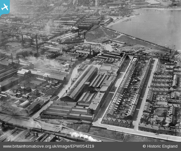
EPW054219 ENGLAND (1937). The Mond Nickel Co Works and other factories on Wiggin Street, Birmingham, 1937
© Copyright OpenStreetMap contributors and licensed by the OpenStreetMap Foundation. 2026. Cartography is licensed as CC BY-SA.
Nearby Images (43)
Details
| Title | [EPW054219] The Mond Nickel Co Works and other factories on Wiggin Street, Birmingham, 1937 |
| Reference | EPW054219 |
| Date | 13-July-1937 |
| Link | |
| Place name | BIRMINGHAM |
| Parish | |
| District | |
| Country | ENGLAND |
| Easting / Northing | 404766, 287198 |
| Longitude / Latitude | -1.9298124369517, 52.48231475717 |
| National Grid Reference | SP048872 |
Pins

Class31 |
Friday 28th of August 2015 09:37:41 AM |


![[EPW054219] The Mond Nickel Co Works and other factories on Wiggin Street, Birmingham, 1937](http://britainfromabove.org.uk/sites/all/libraries/aerofilms-images/public/100x100/EPW/054/EPW054219.jpg)
![[EAW009967] The Mond Nickel Co Ltd Works at Wiggin Street, Rotton Park, 1947. This image was marked by Aerofilms Ltd for photo editing.](http://britainfromabove.org.uk/sites/all/libraries/aerofilms-images/public/100x100/EAW/009/EAW009967.jpg)
![[EAW009969] The Mond Nickel Co Ltd Works at Wiggin Street and Edgbaston Reservoir, Rotton Park, 1947. This image was marked by Aerofilms Ltd for photo editing.](http://britainfromabove.org.uk/sites/all/libraries/aerofilms-images/public/100x100/EAW/009/EAW009969.jpg)
![[EPW035925] The Mond Nickel Co. Works at Wiggin Street, Rotton Park, 1931](http://britainfromabove.org.uk/sites/all/libraries/aerofilms-images/public/100x100/EPW/035/EPW035925.jpg)
![[EPW047137] The Mond Nickel Co research laboratory and the surrounding industrial and residential area, Rotton Park, 1935](http://britainfromabove.org.uk/sites/all/libraries/aerofilms-images/public/100x100/EPW/047/EPW047137.jpg)
![[EPW047136] The Mond Nickel Co research laboratory and the surrounding industrial and residential area, Rotton Park, 1935](http://britainfromabove.org.uk/sites/all/libraries/aerofilms-images/public/100x100/EPW/047/EPW047136.jpg)
![[EPW054218] The Mond Nickel Co Works and other factories on Wiggin Street, Birmingham, 1937](http://britainfromabove.org.uk/sites/all/libraries/aerofilms-images/public/100x100/EPW/054/EPW054218.jpg)
![[EPW035928] The Mond Nickel Co. Works at Wiggin Street, Rotton Park, 1931](http://britainfromabove.org.uk/sites/all/libraries/aerofilms-images/public/100x100/EPW/035/EPW035928.jpg)
![[EPW035927] The Mond Nickel Co. Works at Wiggin Street, Rotton Park, 1931](http://britainfromabove.org.uk/sites/all/libraries/aerofilms-images/public/100x100/EPW/035/EPW035927.jpg)
![[EPW054215] The Mond Nickel Co Works and other factories on Wiggin Street, Birmingham, 1937](http://britainfromabove.org.uk/sites/all/libraries/aerofilms-images/public/100x100/EPW/054/EPW054215.jpg)
![[EPW035924] The Mond Nickel Co. Works at Wiggin Street, Rotton Park, 1931](http://britainfromabove.org.uk/sites/all/libraries/aerofilms-images/public/100x100/EPW/035/EPW035924.jpg)
![[EPW054216] The Mond Nickel Co Works and other factories on Wiggin Street, Birmingham, 1937](http://britainfromabove.org.uk/sites/all/libraries/aerofilms-images/public/100x100/EPW/054/EPW054216.jpg)
![[EPW054222] The Mond Nickel Co Works and other factories on Wiggin Street, Birmingham, 1937](http://britainfromabove.org.uk/sites/all/libraries/aerofilms-images/public/100x100/EPW/054/EPW054222.jpg)
![[EAW009972] The Mond Nickel Co Ltd Works at Wiggin Street and environs, Rotton Park, 1947. This image was marked by Aerofilms Ltd for photo editing.](http://britainfromabove.org.uk/sites/all/libraries/aerofilms-images/public/100x100/EAW/009/EAW009972.jpg)
![[EPW054221] The Mond Nickel Co Works and other factories on Wiggin Street, Birmingham, 1937](http://britainfromabove.org.uk/sites/all/libraries/aerofilms-images/public/100x100/EPW/054/EPW054221.jpg)
![[EPW054220] The Mond Nickel Co Works and other factories on Wiggin Street, Birmingham, 1937](http://britainfromabove.org.uk/sites/all/libraries/aerofilms-images/public/100x100/EPW/054/EPW054220.jpg)
![[EAW009975] The Mond Nickel Co Ltd Works at Wiggin Street and environs, Rotton Park, 1947. This image was marked by Aerofilms Ltd for photo editing.](http://britainfromabove.org.uk/sites/all/libraries/aerofilms-images/public/100x100/EAW/009/EAW009975.jpg)
![[EPW035929] The Mond Nickel Co. Works at Wiggin Street, Rotton Park, 1931](http://britainfromabove.org.uk/sites/all/libraries/aerofilms-images/public/100x100/EPW/035/EPW035929.jpg)
![[EPW047133] The Mond Nickel Co research laboratory and the surrounding industrial and residential area, Rotton Park, 1935](http://britainfromabove.org.uk/sites/all/libraries/aerofilms-images/public/100x100/EPW/047/EPW047133.jpg)
![[EAW009971] The Mond Nickel Co Ltd Works at Wiggin Street and environs, Rotton Park, 1947. This image was marked by Aerofilms Ltd for photo editing.](http://britainfromabove.org.uk/sites/all/libraries/aerofilms-images/public/100x100/EAW/009/EAW009971.jpg)
![[EPW035926] The Mond Nickel Co. Works at Wiggin Street, Rotton Park, 1931](http://britainfromabove.org.uk/sites/all/libraries/aerofilms-images/public/100x100/EPW/035/EPW035926.jpg)
![[EPW047129] The Mond Nickel Co research laboratory and the surrounding industrial and residential area, Rotton Park, 1935](http://britainfromabove.org.uk/sites/all/libraries/aerofilms-images/public/100x100/EPW/047/EPW047129.jpg)
![[EAW009976] The Mond Nickel Co Ltd Works at Wiggin Street and Edgbaston Reservoir, Rotton Park, 1947. This image was marked by Aerofilms Ltd for photo editing.](http://britainfromabove.org.uk/sites/all/libraries/aerofilms-images/public/100x100/EAW/009/EAW009976.jpg)
![[EPW054217] The Mond Nickel Co Works and other factories on Wiggin Street, Birmingham, 1937](http://britainfromabove.org.uk/sites/all/libraries/aerofilms-images/public/100x100/EPW/054/EPW054217.jpg)
![[EPW047131] The Mond Nickel Co research laboratory and the surrounding industrial and residential area, Rotton Park, 1935](http://britainfromabove.org.uk/sites/all/libraries/aerofilms-images/public/100x100/EPW/047/EPW047131.jpg)
![[EPW047135] The Mond Nickel Co research laboratory and the surrounding industrial and residential area, Rotton Park, 1935](http://britainfromabove.org.uk/sites/all/libraries/aerofilms-images/public/100x100/EPW/047/EPW047135.jpg)
![[EPW047134] The Mond Nickel Co research laboratory and the surrounding industrial and residential area, Rotton Park, 1935](http://britainfromabove.org.uk/sites/all/libraries/aerofilms-images/public/100x100/EPW/047/EPW047134.jpg)
![[EPW047132] The Mond Nickel Co research laboratory and the surrounding industrial and residential area, Rotton Park, 1935](http://britainfromabove.org.uk/sites/all/libraries/aerofilms-images/public/100x100/EPW/047/EPW047132.jpg)
![[EPW047130] The Mond Nickel Co research laboratory and the surrounding industrial and residential area, Rotton Park, 1935](http://britainfromabove.org.uk/sites/all/libraries/aerofilms-images/public/100x100/EPW/047/EPW047130.jpg)
![[EAW009968] The Mond Nickel Co Ltd Works at Wiggin Street and environs, Rotton Park, 1947. This image was marked by Aerofilms Ltd for photo editing.](http://britainfromabove.org.uk/sites/all/libraries/aerofilms-images/public/100x100/EAW/009/EAW009968.jpg)
![[EAW016442] The McKechnie Bros Ltd Works and environs, Rotton Park, 1948. This image has been produced from a print marked by Aerofilms Ltd for photo editing.](http://britainfromabove.org.uk/sites/all/libraries/aerofilms-images/public/100x100/EAW/016/EAW016442.jpg)
![[EAW009974] The Mond Nickel Co Ltd Works at Wiggin Street and environs, Rotton Park, 1947. This image was marked by Aerofilms Ltd for photo editing.](http://britainfromabove.org.uk/sites/all/libraries/aerofilms-images/public/100x100/EAW/009/EAW009974.jpg)
![[EAW016443] The McKechnie Bros Ltd Works and environs, Rotton Park, 1948. This image has been produced from a print marked by Aerofilms Ltd for photo editing.](http://britainfromabove.org.uk/sites/all/libraries/aerofilms-images/public/100x100/EAW/016/EAW016443.jpg)
![[EPW009721] Belliss and Morcom Ltd Rotton Park Street Works, Rotton Park, 1923](http://britainfromabove.org.uk/sites/all/libraries/aerofilms-images/public/100x100/EPW/009/EPW009721.jpg)
![[EAW009977] The Mond Nickel Co Ltd Works at Wiggin Street and environs, Rotton Park, 1947. This image was marked by Aerofilms Ltd for photo editing.](http://britainfromabove.org.uk/sites/all/libraries/aerofilms-images/public/100x100/EAW/009/EAW009977.jpg)
![[EAW009973] The Mond Nickel Co Ltd Works at Wiggin Street and environs, Rotton Park, 1947. This image was marked by Aerofilms Ltd for photo editing.](http://britainfromabove.org.uk/sites/all/libraries/aerofilms-images/public/100x100/EAW/009/EAW009973.jpg)
![[EAW016439] The McKechnie Bros Ltd Works (site of) and environs, Rotton Park, 1948. This image has been produced from a damaged negative.](http://britainfromabove.org.uk/sites/all/libraries/aerofilms-images/public/100x100/EAW/016/EAW016439.jpg)
![[EAW009970] The Mond Nickel Co Ltd Works at Wiggin Street and environs, Rotton Park, 1947. This image was marked by Aerofilms Ltd for photo editing.](http://britainfromabove.org.uk/sites/all/libraries/aerofilms-images/public/100x100/EAW/009/EAW009970.jpg)
![[EAW016444] The McKechnie Bros Ltd Works and environs, Rotton Park, 1948. This image has been produced from a print marked by Aerofilms Ltd for photo editing.](http://britainfromabove.org.uk/sites/all/libraries/aerofilms-images/public/100x100/EAW/016/EAW016444.jpg)
![[EAW016441] The McKechnie Bros Ltd Works and environs, Rotton Park, 1948. This image has been produced from a print marked by Aerofilms Ltd for photo editing.](http://britainfromabove.org.uk/sites/all/libraries/aerofilms-images/public/100x100/EAW/016/EAW016441.jpg)
![[EAW016445] The McKechnie Bros Ltd Works and environs, Rotton Park, 1948. This image has been produced from a print marked by Aerofilms Ltd for photo editing.](http://britainfromabove.org.uk/sites/all/libraries/aerofilms-images/public/100x100/EAW/016/EAW016445.jpg)
![[EAW016440] The McKechnie Bros Ltd Works, Rotton Park, 1948. This image has been produced from a print marked by Aerofilms Ltd for photo editing.](http://britainfromabove.org.uk/sites/all/libraries/aerofilms-images/public/100x100/EAW/016/EAW016440.jpg)
![[EAW009978] The Mond Nickel Co Ltd Works at Wiggin Street and environs, Rotton Park, 1947](http://britainfromabove.org.uk/sites/all/libraries/aerofilms-images/public/100x100/EAW/009/EAW009978.jpg)