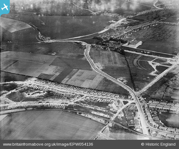
EPW054136 ENGLAND (1937). The A2308 Hangleton Road and surrounding development under construction, Hangleton, 1937
© Copyright OpenStreetMap contributors and licensed by the OpenStreetMap Foundation. 2025. Cartography is licensed as CC BY-SA.
Details
| Title | [EPW054136] The A2308 Hangleton Road and surrounding development under construction, Hangleton, 1937 |
| Reference | EPW054136 |
| Date | 7-July-1937 |
| Link | |
| Place name | HANGLETON |
| Parish | |
| District | |
| Country | ENGLAND |
| Easting / Northing | 527526, 106803 |
| Longitude / Latitude | -0.18835392314948, 50.846116740087 |
| National Grid Reference | TQ275068 |
Pins
 Ade |
Sunday 16th of July 2023 03:47:45 PM | |
 Ade |
Sunday 16th of July 2023 03:44:02 PM | |
 Ade |
Sunday 16th of July 2023 03:42:47 PM | |
 Ade |
Sunday 16th of July 2023 03:39:15 PM | |
 Ade |
Sunday 16th of July 2023 03:36:55 PM | |
 Ade |
Sunday 16th of July 2023 03:36:17 PM | |
 Ade |
Sunday 16th of July 2023 03:34:35 PM | |
 Ade |
Sunday 16th of July 2023 03:31:32 PM | |
 Ade |
Sunday 16th of July 2023 03:30:48 PM | |
 Ade |
Sunday 16th of July 2023 03:29:51 PM | |
 Bayman1 |
Sunday 24th of January 2016 04:45:58 PM | |
 Lindylou |
Saturday 23rd of January 2016 09:02:33 AM | |
 Lindylou |
Friday 22nd of January 2016 07:51:41 PM | |
 Lindylou |
Friday 22nd of January 2016 07:49:45 PM | |
 micky |
Tuesday 21st of January 2014 10:55:04 AM | |
 micky |
Tuesday 21st of January 2014 10:49:01 AM |


![[EPW054136] The A2308 Hangleton Road and surrounding development under construction, Hangleton, 1937](http://britainfromabove.org.uk/sites/all/libraries/aerofilms-images/public/100x100/EPW/054/EPW054136.jpg)
![[EPW054128] The A2308 Hangleton Road and surrounding development under construction, Hangleton, 1937](http://britainfromabove.org.uk/sites/all/libraries/aerofilms-images/public/100x100/EPW/054/EPW054128.jpg)