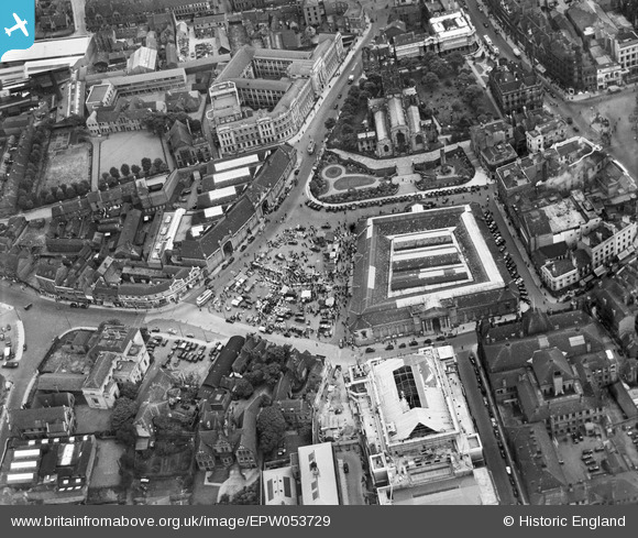
EPW053729 ENGLAND (1937). St Peter's Collegiate Church, the Market Place and the Market Hall, Wolverhampton, 1937
© Copyright OpenStreetMap contributors and licensed by the OpenStreetMap Foundation. 2026. Cartography is licensed as CC BY-SA.
Nearby Images (15)
Details
| Title | [EPW053729] St Peter's Collegiate Church, the Market Place and the Market Hall, Wolverhampton, 1937 |
| Reference | EPW053729 |
| Date | June-1937 |
| Link | |
| Place name | WOLVERHAMPTON |
| Parish | |
| District | |
| Country | ENGLAND |
| Easting / Northing | 391332, 298821 |
| Longitude / Latitude | -2.1279545228103, 52.586767972271 |
| National Grid Reference | SO913988 |
Pins

Claire |
Tuesday 5th of May 2020 12:46:37 PM | |

Claire |
Tuesday 5th of May 2020 12:45:56 PM | |

Claire |
Tuesday 5th of May 2020 12:45:00 PM | |

Claire |
Tuesday 5th of May 2020 12:44:40 PM | |

Claire |
Tuesday 5th of May 2020 12:44:17 PM | |

Claire |
Tuesday 5th of May 2020 12:43:25 PM | |

Claire |
Tuesday 5th of May 2020 12:42:42 PM | |

David960 |
Friday 6th of February 2015 11:45:18 PM |


![[EPW053729] St Peter's Collegiate Church, the Market Place and the Market Hall, Wolverhampton, 1937](http://britainfromabove.org.uk/sites/all/libraries/aerofilms-images/public/100x100/EPW/053/EPW053729.jpg)
![[EPW022897] St Peter's Collegiate Church and the Market Place, Wolverhampton, from the north, 1928](http://britainfromabove.org.uk/sites/all/libraries/aerofilms-images/public/100x100/EPW/022/EPW022897.jpg)
![[EPR000556] Market Hall and the town centre, Wolverhampton, 1935](http://britainfromabove.org.uk/sites/all/libraries/aerofilms-images/public/100x100/EPR/000/EPR000556.jpg)
![[EPW022595] St Peter's Collegiate Church, Wolverhampton, 1928](http://britainfromabove.org.uk/sites/all/libraries/aerofilms-images/public/100x100/EPW/022/EPW022595.jpg)
![[EPW053728] St Peter's Collegiate Church, the Market Hall and the city centre, Wolverhampton, 1937](http://britainfromabove.org.uk/sites/all/libraries/aerofilms-images/public/100x100/EPW/053/EPW053728.jpg)
![[EPW053724] The city centre picturing St Peter's Collegiate Church, the Market Hall and the Molineux Grounds, Wolverhampton, 1937](http://britainfromabove.org.uk/sites/all/libraries/aerofilms-images/public/100x100/EPW/053/EPW053724.jpg)
![[EPW011835] Queen Square and environs, Wolverhampton, 1924. This image has been produced from a print affected by flare.](http://britainfromabove.org.uk/sites/all/libraries/aerofilms-images/public/100x100/EPW/011/EPW011835.jpg)
![[EPW061263] The Molineux Stadium, West Park and the city centre, Wolverhampton, 1939](http://britainfromabove.org.uk/sites/all/libraries/aerofilms-images/public/100x100/EPW/061/EPW061263.jpg)
![[EPW053730] The city centre picturing Victoria Street, the Market Hall and the Civic Hall, Wolverhampton, 1937](http://britainfromabove.org.uk/sites/all/libraries/aerofilms-images/public/100x100/EPW/053/EPW053730.jpg)
![[EPW011832] The city centre, Wolverhampton, 1924. This image has been produced from a copy-negative.](http://britainfromabove.org.uk/sites/all/libraries/aerofilms-images/public/100x100/EPW/011/EPW011832.jpg)
![[EPW057478] The town centre, Wolverhampton, from the north, 1938](http://britainfromabove.org.uk/sites/all/libraries/aerofilms-images/public/100x100/EPW/057/EPW057478.jpg)
![[EPR000569] Victoria Street and the town centre, Wolverhampton, 1935. This image was marked by Aero Pictorial Ltd for photo editing.](http://britainfromabove.org.uk/sites/all/libraries/aerofilms-images/public/100x100/EPR/000/EPR000569.jpg)
![[EPW057476] The town centre, Wolverhampton, 1938](http://britainfromabove.org.uk/sites/all/libraries/aerofilms-images/public/100x100/EPW/057/EPW057476.jpg)
![[EPW011774] Princes Square and environs, Wolverhampton, 1924. This image has been produced from a print.](http://britainfromabove.org.uk/sites/all/libraries/aerofilms-images/public/100x100/EPW/011/EPW011774.jpg)
![[EAW017630] Dudley Street, Market Street and environs, Wolverhampton, 1948. This image has been produced from a print.](http://britainfromabove.org.uk/sites/all/libraries/aerofilms-images/public/100x100/EAW/017/EAW017630.jpg)