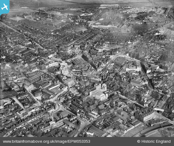
EPW053353 ENGLAND (1937). The town centre, Hanley, 1937
© Copyright OpenStreetMap contributors and licensed by the OpenStreetMap Foundation. 2026. Cartography is licensed as CC BY-SA.
Nearby Images (8)
Details
| Title | [EPW053353] The town centre, Hanley, 1937 |
| Reference | EPW053353 |
| Date | 30-May-1937 |
| Link | |
| Place name | HANLEY |
| Parish | |
| District | |
| Country | ENGLAND |
| Easting / Northing | 388346, 347586 |
| Longitude / Latitude | -2.173771952618, 53.02513247163 |
| National Grid Reference | SJ883476 |
Pins

Andrew Boulton |
Sunday 10th of July 2022 10:58:52 PM | |

cidge |
Wednesday 10th of February 2016 12:31:22 PM | |

cidge |
Tuesday 9th of February 2016 09:05:34 AM | |

cidge |
Sunday 7th of February 2016 07:01:08 PM | |

gBr |
Tuesday 13th of October 2015 03:15:23 PM | |

Tony Boulton |
Monday 7th of July 2014 02:07:08 PM | |

Derek Martin |
Saturday 14th of December 2013 09:03:54 PM | |

Derek Martin |
Saturday 14th of December 2013 09:02:21 PM | |

Derek Martin |
Saturday 14th of December 2013 09:01:50 PM | |

Derek Martin |
Saturday 14th of December 2013 09:01:15 PM |


![[EPW053353] The town centre, Hanley, 1937](http://britainfromabove.org.uk/sites/all/libraries/aerofilms-images/public/100x100/EPW/053/EPW053353.jpg)
![[EPW027585] The Market Square, Fountain Square and Lloyds Bank, Hanley, 1929](http://britainfromabove.org.uk/sites/all/libraries/aerofilms-images/public/100x100/EPW/027/EPW027585.jpg)
![[EPW053356] Fountain Square, Upper Market Square and environs, Hanley, 1937](http://britainfromabove.org.uk/sites/all/libraries/aerofilms-images/public/100x100/EPW/053/EPW053356.jpg)
![[EPW053354] The town centre, Hanley, 1937](http://britainfromabove.org.uk/sites/all/libraries/aerofilms-images/public/100x100/EPW/053/EPW053354.jpg)
![[EPW028010] The town centre, Hanley, 1929](http://britainfromabove.org.uk/sites/all/libraries/aerofilms-images/public/100x100/EPW/028/EPW028010.jpg)
![[EPW042676] Harrison and Son Phoenix Chemical Works, Hanley, 1933](http://britainfromabove.org.uk/sites/all/libraries/aerofilms-images/public/100x100/EPW/042/EPW042676.jpg)
![[EPW042673] Harrison and Son Phoenix Chemical Works, Hanley, 1933](http://britainfromabove.org.uk/sites/all/libraries/aerofilms-images/public/100x100/EPW/042/EPW042673.jpg)
![[EPW042674] Harrison and Son Phoenix Chemical Works, Hanley, 1933](http://britainfromabove.org.uk/sites/all/libraries/aerofilms-images/public/100x100/EPW/042/EPW042674.jpg)

