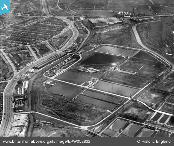
EPW052832 ENGLAND (1937). The Birmingham Tame & Rea District Drainage Board Sewage Farm, Nechells, 1937. This image has been produced from a print.
© Copyright OpenStreetMap contributors and licensed by the OpenStreetMap Foundation. 2026. Cartography is licensed as CC BY-SA.
Nearby Images (36)
Details
| Title | [EPW052832] The Birmingham Tame & Rea District Drainage Board Sewage Farm, Nechells, 1937. This image has been produced from a print. |
| Reference | EPW052832 |
| Date | 9-April-1937 |
| Link | |
| Place name | NECHELLS |
| Parish | |
| District | |
| Country | ENGLAND |
| Easting / Northing | 410612, 289906 |
| Longitude / Latitude | -1.8436339258621, 52.506579864092 |
| National Grid Reference | SP106899 |


![[EPW052832] The Birmingham Tame & Rea District Drainage Board Sewage Farm, Nechells, 1937. This image has been produced from a print.](http://britainfromabove.org.uk/sites/all/libraries/aerofilms-images/public/100x100/EPW/052/EPW052832.jpg)
![[EAW008639] The Birlec Ltd Electric Furnace Works on Tyburn Road and environs, Bromford, 1947](http://britainfromabove.org.uk/sites/all/libraries/aerofilms-images/public/100x100/EAW/008/EAW008639.jpg)
![[EPW047154] The Birlec Electric Furnace Works alongside Tyburn Road and the Birmingham and Fazeley Canal, Gravelly Hill, 1935](http://britainfromabove.org.uk/sites/all/libraries/aerofilms-images/public/100x100/EPW/047/EPW047154.jpg)
![[EPW060535] The Birmingham Electric Furnaces Ltd Works, Erdington, 1939](http://britainfromabove.org.uk/sites/all/libraries/aerofilms-images/public/100x100/EPW/060/EPW060535.jpg)
![[EPW047153] The Birlec Electric Furnace Works alongside Tyburn Road and the Birmingham and Fazeley Canal, Gravelly Hill, 1935](http://britainfromabove.org.uk/sites/all/libraries/aerofilms-images/public/100x100/EPW/047/EPW047153.jpg)
![[EPW054225] The Birlec Ltd Electric Furnace Works on Tyburn Road, Birmingham, 1937](http://britainfromabove.org.uk/sites/all/libraries/aerofilms-images/public/100x100/EPW/054/EPW054225.jpg)
![[EPW047152] The Birlec Electric Furnace Works alongside Tyburn Road and the Birmingham and Fazeley Canal, Gravelly Hill, 1935](http://britainfromabove.org.uk/sites/all/libraries/aerofilms-images/public/100x100/EPW/047/EPW047152.jpg)
![[EPW054228] The Birlec Ltd Electric Furnace Works on Tyburn Road, Birmingham, 1937](http://britainfromabove.org.uk/sites/all/libraries/aerofilms-images/public/100x100/EPW/054/EPW054228.jpg)
![[EAW008633] The Birlec Ltd Electric Furnace Works on Tyburn Road and environs, Bromford, 1947. This image was marked by Aerofilms Ltd for photo editing.](http://britainfromabove.org.uk/sites/all/libraries/aerofilms-images/public/100x100/EAW/008/EAW008633.jpg)
![[EPW060533] The Birmingham Electric Furnaces Ltd Works, Erdington, 1939](http://britainfromabove.org.uk/sites/all/libraries/aerofilms-images/public/100x100/EPW/060/EPW060533.jpg)
![[EPW054226] The Birlec Ltd Electric Furnace Works on Tyburn Road, Birmingham, 1937](http://britainfromabove.org.uk/sites/all/libraries/aerofilms-images/public/100x100/EPW/054/EPW054226.jpg)
![[EPW060470] The Birmingham Electric Furnaces Ltd Works on Tyburn Road, Tyburn, 1939](http://britainfromabove.org.uk/sites/all/libraries/aerofilms-images/public/100x100/EPW/060/EPW060470.jpg)
![[EPW060532] The Birmingham Electric Furnaces Ltd Works, Erdington, 1939](http://britainfromabove.org.uk/sites/all/libraries/aerofilms-images/public/100x100/EPW/060/EPW060532.jpg)
![[EPW054223] The Birlec Ltd Electric Furnace Works on Tyburn Road, Birmingham, 1937](http://britainfromabove.org.uk/sites/all/libraries/aerofilms-images/public/100x100/EPW/054/EPW054223.jpg)
![[EPW060471] The Birmingham Electric Furnaces Ltd Works on Tyburn Road, Tyburn, 1939. This image has been produced from a damaged negative.](http://britainfromabove.org.uk/sites/all/libraries/aerofilms-images/public/100x100/EPW/060/EPW060471.jpg)
![[EPW047155] The Birlec Electric Furnace Works alongside Tyburn Road and the Birmingham and Fazeley Canal, Gravelly Hill, 1935](http://britainfromabove.org.uk/sites/all/libraries/aerofilms-images/public/100x100/EPW/047/EPW047155.jpg)
![[EPW054224] The Birlec Ltd Electric Furnace Works on Tyburn Road, Birmingham, 1937](http://britainfromabove.org.uk/sites/all/libraries/aerofilms-images/public/100x100/EPW/054/EPW054224.jpg)
![[EPW047150] The Birlec Electric Furnace Works alongside Tyburn Road and the Birmingham and Fazeley Canal, Gravelly Hill, 1935](http://britainfromabove.org.uk/sites/all/libraries/aerofilms-images/public/100x100/EPW/047/EPW047150.jpg)
![[EPW060531] The Birmingham Electric Furnaces Ltd Works, Erdington, 1939](http://britainfromabove.org.uk/sites/all/libraries/aerofilms-images/public/100x100/EPW/060/EPW060531.jpg)
![[EAW008635] The Birlec Ltd Electric Furnace Works on Tyburn Road, Bromford, 1947](http://britainfromabove.org.uk/sites/all/libraries/aerofilms-images/public/100x100/EAW/008/EAW008635.jpg)
![[EAW008636] The Birlec Ltd Electric Furnace Works on Tyburn Road, Bromford, 1947](http://britainfromabove.org.uk/sites/all/libraries/aerofilms-images/public/100x100/EAW/008/EAW008636.jpg)
![[EAW008640] The Birlec Ltd Electric Furnace Works on Tyburn Road and environs, Bromford, 1947](http://britainfromabove.org.uk/sites/all/libraries/aerofilms-images/public/100x100/EAW/008/EAW008640.jpg)
![[EPW060534] The Birmingham Electric Furnaces Ltd Works, Erdington, 1939](http://britainfromabove.org.uk/sites/all/libraries/aerofilms-images/public/100x100/EPW/060/EPW060534.jpg)
![[EPW060537] The Birmingham Electric Furnaces Ltd Works, Erdington, 1939](http://britainfromabove.org.uk/sites/all/libraries/aerofilms-images/public/100x100/EPW/060/EPW060537.jpg)
![[EAW008634] The Birlec Ltd Electric Furnace Works on Tyburn Road, Bromford, 1947](http://britainfromabove.org.uk/sites/all/libraries/aerofilms-images/public/100x100/EAW/008/EAW008634.jpg)
![[EPW060536] The Birmingham Electric Furnaces Ltd Works, Erdington, 1939](http://britainfromabove.org.uk/sites/all/libraries/aerofilms-images/public/100x100/EPW/060/EPW060536.jpg)
![[EPW054227] The Birlec Ltd Electric Furnace Works on Tyburn Road, Birmingham, 1937](http://britainfromabove.org.uk/sites/all/libraries/aerofilms-images/public/100x100/EPW/054/EPW054227.jpg)
![[EPW047151] The Birlec Electric Furnace Works alongside Tyburn Road and the Birmingham and Fazeley Canal, Gravelly Hill, 1935](http://britainfromabove.org.uk/sites/all/libraries/aerofilms-images/public/100x100/EPW/047/EPW047151.jpg)
![[EAW008638] The Birlec Ltd Electric Furnace Works on Tyburn Road and environs, Bromford, 1947](http://britainfromabove.org.uk/sites/all/libraries/aerofilms-images/public/100x100/EAW/008/EAW008638.jpg)
![[EPW052829] Filter Beds at the Birmingham Tame & Rea District Drainage Board Sewage Farm, Nechells, 1937](http://britainfromabove.org.uk/sites/all/libraries/aerofilms-images/public/100x100/EPW/052/EPW052829.jpg)
![[EPW047156] The Birlec Electric Furnace Works alongside Tyburn Road and the Birmingham and Fazeley Canal, Gravelly Hill, 1935](http://britainfromabove.org.uk/sites/all/libraries/aerofilms-images/public/100x100/EPW/047/EPW047156.jpg)
![[EPW047149] The Birlec Electric Furnace Works alongside Tyburn Road and the Birmingham and Fazeley Canal, Gravelly Hill, 1935](http://britainfromabove.org.uk/sites/all/libraries/aerofilms-images/public/100x100/EPW/047/EPW047149.jpg)
![[EAW008631] The Birlec Ltd Electric Furnace Works on Tyburn Road, Bromford, 1947. This image was marked by Aerofilms Ltd for photo editing.](http://britainfromabove.org.uk/sites/all/libraries/aerofilms-images/public/100x100/EAW/008/EAW008631.jpg)
![[EAW008637] The Birlec Ltd Electric Furnace Works on Tyburn Road and environs, Bromford, 1947. This image was marked by Aerofilms Ltd for photo editing.](http://britainfromabove.org.uk/sites/all/libraries/aerofilms-images/public/100x100/EAW/008/EAW008637.jpg)
![[EAW008632] The Birlec Ltd Electric Furnace Works on Tyburn Road and environs, Bromford, from the north-east, 1947](http://britainfromabove.org.uk/sites/all/libraries/aerofilms-images/public/100x100/EAW/008/EAW008632.jpg)
![[EPW047157] The Birlec Electric Furnace Works and the surrounding residential area, Gravelly Hill, 1935](http://britainfromabove.org.uk/sites/all/libraries/aerofilms-images/public/100x100/EPW/047/EPW047157.jpg)
