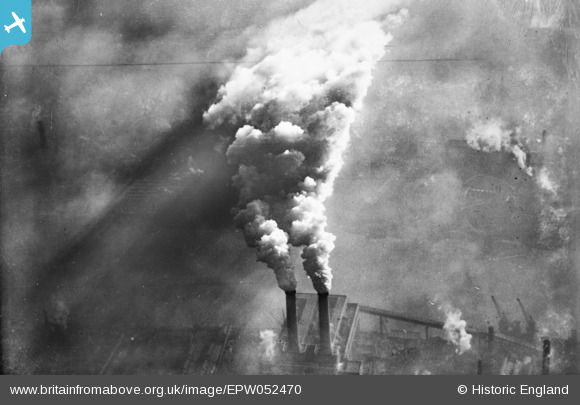
EPW052470 ENGLAND (1937). Smoke rising from Fulham Power Station, Sands End, from the west, 1937. This image has been produced fropm a copy-negative.
© Copyright OpenStreetMap contributors and licensed by the OpenStreetMap Foundation. 2026. Cartography is licensed as CC BY-SA.
Nearby Images (21)
Details
| Title | [EPW052470] Smoke rising from Fulham Power Station, Sands End, from the west, 1937. This image has been produced fropm a copy-negative. |
| Reference | EPW052470 |
| Date | 13-February-1937 |
| Link | |
| Place name | SANDS END |
| Parish | |
| District | |
| Country | ENGLAND |
| Easting / Northing | 526336, 176048 |
| Longitude / Latitude | -0.18092991248267, 51.468790587812 |
| National Grid Reference | TQ263760 |
Pins
Be the first to add a comment to this image!


![[EPW052470] Smoke rising from Fulham Power Station, Sands End, from the west, 1937. This image has been produced fropm a copy-negative.](http://britainfromabove.org.uk/sites/all/libraries/aerofilms-images/public/100x100/EPW/052/EPW052470.jpg)
![[EPW052470A] Smoke rising from Fulham Power Station, Sands End, from the west, 1937. This image has been produced fropm a copy-negative.](http://britainfromabove.org.uk/sites/all/libraries/aerofilms-images/public/100x100/EPW/052/EPW052470A.jpg)
![[EPW052469] Smoke rising from Fulham Power Station, Sands End, from the north, 1937. This image has been produced fropm a copy-negative.](http://britainfromabove.org.uk/sites/all/libraries/aerofilms-images/public/100x100/EPW/052/EPW052469.jpg)
![[EPW052473] Fulham Power Station, Sands End, from the west, 1937](http://britainfromabove.org.uk/sites/all/libraries/aerofilms-images/public/100x100/EPW/052/EPW052473.jpg)
![[EPW052472] Fulham Power Station, Sands End, from the west, 1937](http://britainfromabove.org.uk/sites/all/libraries/aerofilms-images/public/100x100/EPW/052/EPW052472.jpg)
![[EPW052681] Fulham Power Station, Sands End, 1937](http://britainfromabove.org.uk/sites/all/libraries/aerofilms-images/public/100x100/EPW/052/EPW052681.jpg)
![[EPW052471] Fulham Power Station, Sands End, 1937](http://britainfromabove.org.uk/sites/all/libraries/aerofilms-images/public/100x100/EPW/052/EPW052471.jpg)
![[EPW021418] Price's Belmont Candle and Soap Works, Battersea, 1928](http://britainfromabove.org.uk/sites/all/libraries/aerofilms-images/public/100x100/EPW/021/EPW021418.jpg)
![[EPW021413] Price's Belmont Candle and Soap Works, Battersea, 1928](http://britainfromabove.org.uk/sites/all/libraries/aerofilms-images/public/100x100/EPW/021/EPW021413.jpg)
![[EPW021415] Price's Belmont Candle and Soap Works, the Sugar Works and environs, Battersea, 1928](http://britainfromabove.org.uk/sites/all/libraries/aerofilms-images/public/100x100/EPW/021/EPW021415.jpg)
![[EPW021412] Price's Belmont Candle and Soap Works, Battersea, 1928](http://britainfromabove.org.uk/sites/all/libraries/aerofilms-images/public/100x100/EPW/021/EPW021412.jpg)
![[EPW021414] Price's Belmont Candle and Soap Works, the Sugar Works and environs, Battersea, 1928](http://britainfromabove.org.uk/sites/all/libraries/aerofilms-images/public/100x100/EPW/021/EPW021414.jpg)
![[EPW053655] The River Thames at Battersea Creek and environs, Battersea, 1937](http://britainfromabove.org.uk/sites/all/libraries/aerofilms-images/public/100x100/EPW/053/EPW053655.jpg)
![[EPW021256] The Imperial Biscuit Works and environs, Sands End, from the south-west, 1928](http://britainfromabove.org.uk/sites/all/libraries/aerofilms-images/public/100x100/EPW/021/EPW021256.jpg)
![[EPW021411] Price's Belmont Candle and Soap Works, Battersea, 1928](http://britainfromabove.org.uk/sites/all/libraries/aerofilms-images/public/100x100/EPW/021/EPW021411.jpg)
![[EPW060457] Wandsworth Bridge under construction and the surrounding residential and industrial area along the banks of the River Thames, Sands End, 1939](http://britainfromabove.org.uk/sites/all/libraries/aerofilms-images/public/100x100/EPW/060/EPW060457.jpg)
![[EPW045409] An industrial building under construction on the riverside, Sands End, 1934](http://britainfromabove.org.uk/sites/all/libraries/aerofilms-images/public/100x100/EPW/045/EPW045409.jpg)
![[EPW021417] Price's Belmont Candle and Soap Works and the Sugar Works at Southampton Wharf, Battersea, 1928](http://britainfromabove.org.uk/sites/all/libraries/aerofilms-images/public/100x100/EPW/021/EPW021417.jpg)
![[EPW021410] Price's Belmont Candle and Soap Works and the Sugar Works at Southampton Wharf, Battersea, 1928](http://britainfromabove.org.uk/sites/all/libraries/aerofilms-images/public/100x100/EPW/021/EPW021410.jpg)
![[EPW041103] Garton Sons & Co Sugar Works and environs, Battersea, 1933](http://britainfromabove.org.uk/sites/all/libraries/aerofilms-images/public/100x100/EPW/041/EPW041103.jpg)
![[EPW041100] Garton Sons & Co Sugar Works and environs, Battersea, 1933](http://britainfromabove.org.uk/sites/all/libraries/aerofilms-images/public/100x100/EPW/041/EPW041100.jpg)