
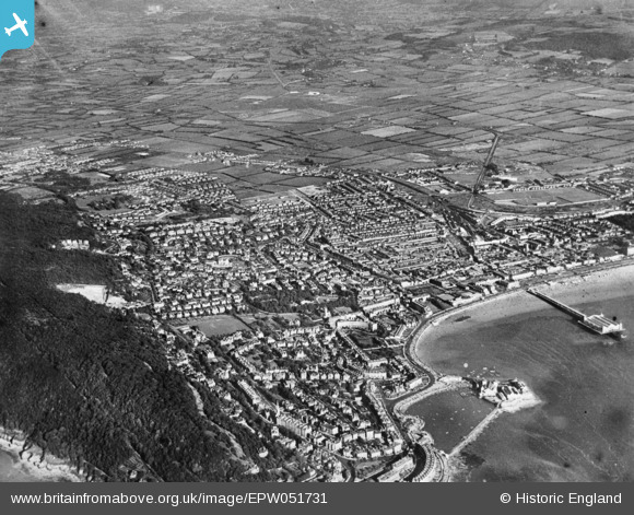
EPW051731 ENGLAND (1936). Glentworth Bay and the town, Weston-super-Mare, from the north-west, 1936. This image has been produced from a copy-negative.
© Copyright OpenStreetMap contributors and licensed by the OpenStreetMap Foundation. 2026. Cartography is licensed as CC BY-SA.
Nearby Images (6)
EPW051731

EAW025150

EPW033277

EPW001034

EPW001037

EAW015054

Details
| Title | [EPW051731] Glentworth Bay and the town, Weston-super-Mare, from the north-west, 1936. This image has been produced from a copy-negative. |
| Reference | EPW051731 |
| Date | August-1936 |
| Link | |
| Place name | WESTON-SUPER-MARE |
| Parish | WESTON-SUPER-MARE |
| District | |
| Country | ENGLAND |
| Easting / Northing | 331643, 162077 |
| Longitude / Latitude | -2.9817436554654, 51.3531512266 |
| National Grid Reference | ST316621 |
Pins

gBr |
Sunday 4th of October 2015 02:27:19 PM | |
|
gBr |
Sunday 4th of October 2015 02:25:20 PM | |
|
gBr |
Sunday 4th of October 2015 02:07:09 PM | |
|
gBr |
Sunday 4th of October 2015 02:05:41 PM | |
|
Graham Yaxley |
Tuesday 24th of February 2015 12:55:04 AM |