
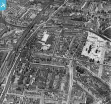
EPW050854 ENGLAND (1936). The Infirmary and the residential area at Bethnal Green, Bethnal Green, 1936

© Copyright OpenStreetMap contributors and licensed by the OpenStreetMap Foundation. 2026. Cartography is licensed as CC BY-SA.
Nearby Images (3)
EPW050854

EPW050855

EPW050849

Details
| Title | [EPW050854] The Infirmary and the residential area at Bethnal Green, Bethnal Green, 1936 |
| Reference | EPW050854 |
| Date | June-1936 |
| Link | |
| Place name | BETHNAL GREEN |
| Parish | |
| District | |
| Country | ENGLAND |
| Easting / Northing | 534990, 183366 |
| Longitude / Latitude | -0.053597874921535, 51.532561250783 |
| National Grid Reference | TQ350834 |
Pins

ray 7 |
Wednesday 20th of May 2020 12:21:22 PM | |
|
ray 7 |
Wednesday 20th of May 2020 12:20:01 PM | |
|
TinyTim |
Thursday 30th of July 2015 06:13:36 PM | |
|
John Wass |
Tuesday 19th of May 2015 11:08:24 AM | |
|
billyfern |
Sunday 2nd of November 2014 07:11:29 PM | |
|
billyfern |
Sunday 2nd of November 2014 07:10:32 PM | |
|
S00Z |
Tuesday 5th of November 2013 04:13:06 PM | |
|
S00Z |
Friday 20th of September 2013 12:48:03 AM | |
|
S00Z |
Friday 20th of September 2013 12:47:26 AM | |
|
ken |
Sunday 2nd of June 2013 12:04:55 AM |
User Comment Contributions
the lane |
ken |
Friday 23rd of August 2013 07:53:49 PM |