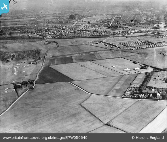
EPW050649 ENGLAND (1936). The Diamond Works Sports Ground, housing development around Kirrkstone Road South and environs, Litherland, from the north-west, 1936
© Copyright OpenStreetMap contributors and licensed by the OpenStreetMap Foundation. 2026. Cartography is licensed as CC BY-SA.
Details
| Title | [EPW050649] The Diamond Works Sports Ground, housing development around Kirrkstone Road South and environs, Litherland, from the north-west, 1936 |
| Reference | EPW050649 |
| Date | June-1936 |
| Link | |
| Place name | LITHERLAND |
| Parish | |
| District | |
| Country | ENGLAND |
| Easting / Northing | 334520, 398867 |
| Longitude / Latitude | -2.9868438399116, 53.482192753441 |
| National Grid Reference | SJ345989 |
Pins

lynn |
Tuesday 30th of September 2025 12:04:02 AM | |

Raymondo |
Friday 7th of October 2022 12:50:19 PM | |

Ange |
Tuesday 23rd of June 2020 02:39:14 PM | |

Ange |
Tuesday 23rd of June 2020 02:36:42 PM | |

Ange |
Tuesday 23rd of June 2020 02:35:39 PM | |

Ange |
Tuesday 23rd of June 2020 02:34:09 PM | |

Ange |
Tuesday 23rd of June 2020 02:33:25 PM | |

john |
Friday 4th of July 2014 03:27:33 PM | |

john |
Friday 4th of July 2014 03:22:38 PM | |

john |
Friday 4th of July 2014 03:19:34 PM | |

Lord Axminister |
Tuesday 10th of June 2014 11:04:44 PM | |

Lord Axminister |
Monday 9th of June 2014 05:51:49 PM | |

Ronnie |
Wednesday 18th of December 2013 10:14:10 AM | |

Ronnie |
Wednesday 18th of December 2013 10:13:36 AM | |

Ronnie |
Wednesday 18th of December 2013 10:10:17 AM | |
Also an orphanage. My Grandad was an orphan and lived there. Now NunsFord Close. |

john |
Friday 4th of July 2014 03:16:22 PM |

Ange |
Saturday 17th of August 2013 10:22:28 PM | |

Ange |
Saturday 17th of August 2013 10:19:16 PM |


![[EPW050649] The Diamond Works Sports Ground, housing development around Kirrkstone Road South and environs, Litherland, from the north-west, 1936](http://britainfromabove.org.uk/sites/all/libraries/aerofilms-images/public/100x100/EPW/050/EPW050649.jpg)
![[EAW050723] New houses under construction between Sterrix Lane and the Leeds and Liverpool Canal, Litherland, from the south-east, 1953](http://britainfromabove.org.uk/sites/all/libraries/aerofilms-images/public/100x100/EAW/050/EAW050723.jpg)
![[EPW050648] Bootle Golf Course, housing development around Kirkstone Road South and Church Road and environs, Litherland, from the north, 1936](http://britainfromabove.org.uk/sites/all/libraries/aerofilms-images/public/100x100/EPW/050/EPW050648.jpg)