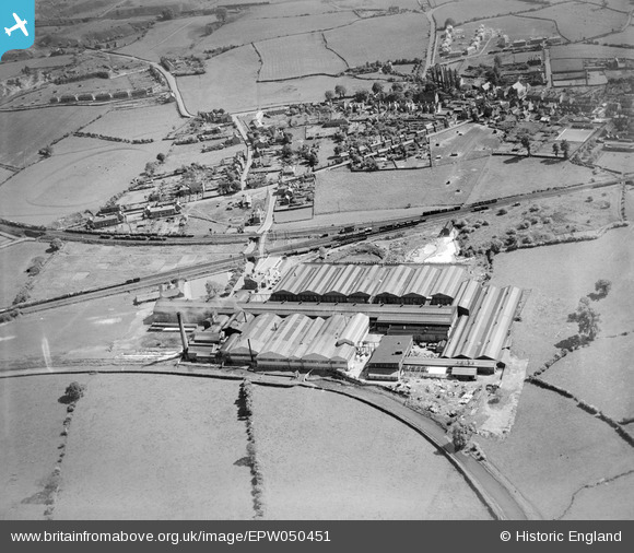
EPW050451 ENGLAND (1936). Joseph Sankey & Sons Ltd Castle Engineering Works and the village, Hadley, 1936
© Copyright OpenStreetMap contributors and licensed by the OpenStreetMap Foundation. 2026. Cartography is licensed as CC BY-SA.
Nearby Images (28)
Details
| Title | [EPW050451] Joseph Sankey & Sons Ltd Castle Engineering Works and the village, Hadley, 1936 |
| Reference | EPW050451 |
| Date | June-1936 |
| Link | |
| Place name | HADLEY |
| Parish | HADLEY & LEEGOMERY |
| District | |
| Country | ENGLAND |
| Easting / Northing | 367719, 312361 |
| Longitude / Latitude | -2.4778395280049, 52.707609064735 |
| National Grid Reference | SJ677124 |
Pins

Suzanne Pryce |
Sunday 1st of September 2019 04:17:18 PM | |

totoro |
Friday 7th of February 2014 06:55:39 PM | |

totoro |
Friday 7th of February 2014 06:55:20 PM | |

totoro |
Friday 7th of February 2014 06:55:04 PM | |

totoro |
Friday 7th of February 2014 06:54:44 PM | |

totoro |
Friday 7th of February 2014 06:50:55 PM | |

totoro |
Friday 7th of February 2014 06:49:17 PM |


![[EPW050451] Joseph Sankey & Sons Ltd Castle Engineering Works and the village, Hadley, 1936](http://britainfromabove.org.uk/sites/all/libraries/aerofilms-images/public/100x100/EPW/050/EPW050451.jpg)
![[EAW052792] Joseph Sankey and Sons Ltd Hadley Castle Works, Hadley, 1953. This image was marked by Aerofilms Ltd for photo editing.](http://britainfromabove.org.uk/sites/all/libraries/aerofilms-images/public/100x100/EAW/052/EAW052792.jpg)
![[EAW027675] Joseph Sankey & Sons Ltd Hadley Castle Works, Hadley Castle, 1949. This image has been produced from a print marked by Aerofilms Ltd for photo editing.](http://britainfromabove.org.uk/sites/all/libraries/aerofilms-images/public/100x100/EAW/027/EAW027675.jpg)
![[EPW050449] Joseph Sankey & Sons Ltd Castle Engineering Works and the village, Hadley, 1936](http://britainfromabove.org.uk/sites/all/libraries/aerofilms-images/public/100x100/EPW/050/EPW050449.jpg)
![[EPW050453] Joseph Sankey & Sons Ltd Castle Engineering Works, Hadley, 1936](http://britainfromabove.org.uk/sites/all/libraries/aerofilms-images/public/100x100/EPW/050/EPW050453.jpg)
![[EAW027681] Joseph Sankey & Sons Ltd Hadley Castle Works, Hadley Castle, 1949. This image was marked by Aerofilms Ltd for photo editing.](http://britainfromabove.org.uk/sites/all/libraries/aerofilms-images/public/100x100/EAW/027/EAW027681.jpg)
![[EPW050452] Joseph Sankey & Sons Ltd Castle Engineering Works, Hadley, 1936](http://britainfromabove.org.uk/sites/all/libraries/aerofilms-images/public/100x100/EPW/050/EPW050452.jpg)
![[EAW027680] Joseph Sankey & Sons Ltd Hadley Castle Works, Hadley Castle, 1949](http://britainfromabove.org.uk/sites/all/libraries/aerofilms-images/public/100x100/EAW/027/EAW027680.jpg)
![[EAW027672] Joseph Sankey & Sons Ltd Hadley Castle Works, Hadley Castle, 1949. This image was marked by Aerofilms Ltd for photo editing.](http://britainfromabove.org.uk/sites/all/libraries/aerofilms-images/public/100x100/EAW/027/EAW027672.jpg)
![[EAW027683] Joseph Sankey & Sons Ltd Hadley Castle Works and environs, Hadley Castle, 1949. This image was marked by Aerofilms Ltd for photo editing.](http://britainfromabove.org.uk/sites/all/libraries/aerofilms-images/public/100x100/EAW/027/EAW027683.jpg)
![[EAW047556] The Joseph Sankey and Sons Ltd Castle Engineering Works, Hadley Castle, 1952. This image was marked by Aerofilms Ltd for photo editing.](http://britainfromabove.org.uk/sites/all/libraries/aerofilms-images/public/100x100/EAW/047/EAW047556.jpg)
![[EPW050450] Joseph Sankey & Sons Ltd Castle Engineering Works, Hadley, 1936](http://britainfromabove.org.uk/sites/all/libraries/aerofilms-images/public/100x100/EPW/050/EPW050450.jpg)
![[EAW047555] The Joseph Sankey and Sons Ltd Castle Engineering Works, Hadley Castle, 1952. This image was marked by Aerofilms Ltd for photo editing.](http://britainfromabove.org.uk/sites/all/libraries/aerofilms-images/public/100x100/EAW/047/EAW047555.jpg)
![[EAW027682] Joseph Sankey & Sons Ltd Hadley Castle Works and environs, Hadley Castle, 1949. This image was marked by Aerofilms Ltd for photo editing.](http://britainfromabove.org.uk/sites/all/libraries/aerofilms-images/public/100x100/EAW/027/EAW027682.jpg)
![[EAW047553] The Joseph Sankey and Sons Ltd Castle Engineering Works, Hadley Castle, 1952. This image was marked by Aerofilms Ltd for photo editing.](http://britainfromabove.org.uk/sites/all/libraries/aerofilms-images/public/100x100/EAW/047/EAW047553.jpg)
![[EAW047547] The Joseph Sankey and Sons Ltd Castle Engineering Works, Hadley Castle, 1952. This image was marked by Aerofilms Ltd for photo editing.](http://britainfromabove.org.uk/sites/all/libraries/aerofilms-images/public/100x100/EAW/047/EAW047547.jpg)
![[EPW050454] Joseph Sankey & Sons Ltd Castle Engineering Works and environs, Hadley, 1936](http://britainfromabove.org.uk/sites/all/libraries/aerofilms-images/public/100x100/EPW/050/EPW050454.jpg)
![[EAW027669] Joseph Sankey & Sons Ltd Hadley Castle Works, Hadley Castle, 1949. This image was marked by Aerofilms Ltd for photo editing.](http://britainfromabove.org.uk/sites/all/libraries/aerofilms-images/public/100x100/EAW/027/EAW027669.jpg)
![[EAW027674] Joseph Sankey & Sons Ltd Hadley Castle Works, Hadley Castle, 1949. This image was marked by Aerofilms Ltd for photo editing.](http://britainfromabove.org.uk/sites/all/libraries/aerofilms-images/public/100x100/EAW/027/EAW027674.jpg)
![[EAW047549] The Joseph Sankey and Sons Ltd Castle Engineering Works, Hadley Castle, 1952. This image was marked by Aerofilms Ltd for photo editing.](http://britainfromabove.org.uk/sites/all/libraries/aerofilms-images/public/100x100/EAW/047/EAW047549.jpg)
![[EPW050455] Joseph Sankey & Sons Ltd Castle Engineering Works and environs, Hadley, 1936](http://britainfromabove.org.uk/sites/all/libraries/aerofilms-images/public/100x100/EPW/050/EPW050455.jpg)
![[EAW052793] Joseph Sankey and Sons Ltd Hadley Castle Works, Hadley, 1953. This image was marked by Aerofilms Ltd for photo editing.](http://britainfromabove.org.uk/sites/all/libraries/aerofilms-images/public/100x100/EAW/052/EAW052793.jpg)
![[EAW027673] Joseph Sankey & Sons Ltd Hadley Castle Works, Hadley Castle, 1949. This image was marked by Aerofilms Ltd for photo editing.](http://britainfromabove.org.uk/sites/all/libraries/aerofilms-images/public/100x100/EAW/027/EAW027673.jpg)
![[EAW052794] Joseph Sankey and Sons Ltd Hadley Castle Works, Hadley, from the south, 1953. This image was marked by Aerofilms Ltd for photo editing.](http://britainfromabove.org.uk/sites/all/libraries/aerofilms-images/public/100x100/EAW/052/EAW052794.jpg)
![[EAW027671] Joseph Sankey & Sons Ltd Hadley Castle Works, Hadley Castle, 1949. This image was marked by Aerofilms Ltd for photo editing.](http://britainfromabove.org.uk/sites/all/libraries/aerofilms-images/public/100x100/EAW/027/EAW027671.jpg)
![[EAW047554] The Joseph Sankey and Sons Ltd Castle Engineering Works, Hadley Castle, 1952. This image was marked by Aerofilms Ltd for photo editing.](http://britainfromabove.org.uk/sites/all/libraries/aerofilms-images/public/100x100/EAW/047/EAW047554.jpg)
![[EAW027677] Joseph Sankey & Sons Ltd Hadley Castle Works, Hadley Castle, 1949. This image has been produced from a print marked by Aerofilms Ltd for photo editing.](http://britainfromabove.org.uk/sites/all/libraries/aerofilms-images/public/100x100/EAW/027/EAW027677.jpg)
![[EAW052795] Joseph Sankey and Sons Ltd Hadley Castle Works, Hadley, from the north-east, 1953. This image was marked by Aerofilms Ltd for photo editing.](http://britainfromabove.org.uk/sites/all/libraries/aerofilms-images/public/100x100/EAW/052/EAW052795.jpg)