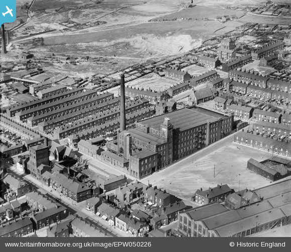
EPW050226 ENGLAND (1936). Coldhurst Hall Cotton Mill and environs, Oldham, 1936
© Copyright OpenStreetMap contributors and licensed by the OpenStreetMap Foundation. 2026. Cartography is licensed as CC BY-SA.
Nearby Images (18)
Details
| Title | [EPW050226] Coldhurst Hall Cotton Mill and environs, Oldham, 1936 |
| Reference | EPW050226 |
| Date | May-1936 |
| Link | |
| Place name | OLDHAM |
| Parish | |
| District | |
| Country | ENGLAND |
| Easting / Northing | 392265, 405956 |
| Longitude / Latitude | -2.1167579925925, 53.549936010618 |
| National Grid Reference | SD923060 |
Pins

Oldham man |
Thursday 15th of August 2019 02:04:55 AM | |

eddief |
Monday 9th of December 2013 08:42:56 PM | |

eddief |
Monday 9th of December 2013 08:35:32 PM | |

eddief |
Monday 9th of December 2013 08:34:45 PM | |

eddief |
Monday 9th of December 2013 08:33:52 PM | |

Terry |
Tuesday 15th of October 2013 07:01:16 PM | |

eddief |
Sunday 16th of June 2013 05:17:52 PM | |

eddief |
Sunday 16th of June 2013 05:16:41 PM | |

eddief |
Sunday 16th of June 2013 05:15:14 PM | |

eddief |
Sunday 16th of June 2013 05:12:58 PM | |

eddief |
Sunday 16th of June 2013 04:55:40 PM | |

eddief |
Sunday 16th of June 2013 04:53:41 PM | |

eddief |
Sunday 16th of June 2013 04:52:40 PM | |

eddief |
Sunday 16th of June 2013 04:51:51 PM | |

eddief |
Sunday 16th of June 2013 03:59:47 PM | |

eddief |
Sunday 16th of June 2013 03:58:04 PM |


![[EPW050226] Coldhurst Hall Cotton Mill and environs, Oldham, 1936](http://britainfromabove.org.uk/sites/all/libraries/aerofilms-images/public/100x100/EPW/050/EPW050226.jpg)
![[EPW050228] Coldhurst Hall Cotton Mill and environs, Oldham, 1936](http://britainfromabove.org.uk/sites/all/libraries/aerofilms-images/public/100x100/EPW/050/EPW050228.jpg)
![[EAW004276] Coldhurst Hall Cotton Mill and environs, Oldham, 1947](http://britainfromabove.org.uk/sites/all/libraries/aerofilms-images/public/100x100/EAW/004/EAW004276.jpg)
![[EPW050224] Coldhurst Hall Cotton Mill, Magdala Street and environs, Oldham, 1936](http://britainfromabove.org.uk/sites/all/libraries/aerofilms-images/public/100x100/EPW/050/EPW050224.jpg)
![[EPW050227] Coldhurst Hall Cotton Mill and environs, Oldham, 1936](http://britainfromabove.org.uk/sites/all/libraries/aerofilms-images/public/100x100/EPW/050/EPW050227.jpg)
![[EPW050225] Coldhurst Hall Cotton Mill, Magdala Street and environs, Oldham, 1936](http://britainfromabove.org.uk/sites/all/libraries/aerofilms-images/public/100x100/EPW/050/EPW050225.jpg)
![[EAW004281] Coldhurst Hall Cotton Mill and environs, Oldham, 1947. This image was marked by Aerofilms Ltd for photo editing.](http://britainfromabove.org.uk/sites/all/libraries/aerofilms-images/public/100x100/EAW/004/EAW004281.jpg)
![[EAW004280] Coldhurst Hall Cotton Mill and environs, Oldham, 1947](http://britainfromabove.org.uk/sites/all/libraries/aerofilms-images/public/100x100/EAW/004/EAW004280.jpg)
![[EPW050229] Coldhurst Hall Cotton Mill and environs, Oldham, 1936](http://britainfromabove.org.uk/sites/all/libraries/aerofilms-images/public/100x100/EPW/050/EPW050229.jpg)
![[EAW004278] Coldhurst Hall Cotton Mill and environs, Oldham, 1947. This image was marked by Aerofilms Ltd for photo editing.](http://britainfromabove.org.uk/sites/all/libraries/aerofilms-images/public/100x100/EAW/004/EAW004278.jpg)
![[EAW004277] Coldhurst Hall Cotton Mill and environs, Oldham, 1947](http://britainfromabove.org.uk/sites/all/libraries/aerofilms-images/public/100x100/EAW/004/EAW004277.jpg)
![[EAW004279] Coldhurst Hall Cotton Mill and environs, Oldham, 1947. This image was marked by Aerofilms Ltd for photo editing.](http://britainfromabove.org.uk/sites/all/libraries/aerofilms-images/public/100x100/EAW/004/EAW004279.jpg)
![[EAW004431] The Hargreaves Spindle Works at Coldhurst, Oldham, 1947. This image was marked by Aerofilms Ltd for photo editing.](http://britainfromabove.org.uk/sites/all/libraries/aerofilms-images/public/100x100/EAW/004/EAW004431.jpg)
![[EAW004430] The Hargreaves Spindle Works at Coldhurst, Oldham, 1947](http://britainfromabove.org.uk/sites/all/libraries/aerofilms-images/public/100x100/EAW/004/EAW004430.jpg)
![[EAW004434] The Hargreaves Spindle Works at Coldhurst, Oldham, 1947. This image was marked by Aerofilms Ltd for photo editing.](http://britainfromabove.org.uk/sites/all/libraries/aerofilms-images/public/100x100/EAW/004/EAW004434.jpg)
![[EAW004432] The Hargreaves Spindle Works at Coldhurst, Oldham, 1947. This image was marked by Aerofilms Ltd for photo editing.](http://britainfromabove.org.uk/sites/all/libraries/aerofilms-images/public/100x100/EAW/004/EAW004432.jpg)
![[EAW004435] The Hargreaves Spindle Works at Coldhurst, Oldham, from the south-west, 1947. This image was marked by Aerofilms Ltd for photo editing.](http://britainfromabove.org.uk/sites/all/libraries/aerofilms-images/public/100x100/EAW/004/EAW004435.jpg)
![[EAW004433] The Hargreaves Spindle Works at Coldhurst, Oldham, 1947. This image has been produced from a print marked by Aerofilms Ltd for photo editing.](http://britainfromabove.org.uk/sites/all/libraries/aerofilms-images/public/100x100/EAW/004/EAW004433.jpg)