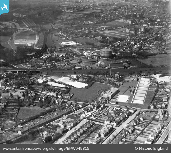
EPW049815 ENGLAND (1936). The Colne Valley Water Company Plc Water Works and environs, Bushey, from the east, 1936
    © Copyright OpenStreetMap contributors and licensed by the OpenStreetMap Foundation. 2025. Cartography is licensed as CC BY-SA.
  
Nearby Images (10)
Details
| Title | [EPW049815] The Colne Valley Water Company Plc Water Works and environs, Bushey, from the east, 1936 | 
| Reference | EPW049815 | 
| Date | May-1936 | 
| Link | |
| Place name | BUSHEY | 
| Parish | |
| District | |
| Country | ENGLAND | 
| Easting / Northing | 512089, 195654 | 
| Longitude / Latitude | -0.37972238387671, 51.64802779353 | 
| National Grid Reference | TQ121957 | 
Pins
|   ordinarybloke | Sunday 19th of March 2023 10:08:51 AM | |
|  Colney Butts Allotments | John Swain | Tuesday 27th of August 2013 11:47:58 AM | 
|  Watford Union Workhouse renamed Shrodells Public Assistance Institution (under Watford Borough Council) in 1930. | John Swain | Tuesday 27th of August 2013 11:46:52 AM | 
|  Watford FC ground at Vicarage Road | John Swain | Tuesday 27th of August 2013 11:42:32 AM | 
|  Benskin's Brewery | John Swain | Tuesday 27th of August 2013 11:40:16 AM | 
|  Watford Grammar School for Girls opened in 1907. | John Swain | Tuesday 27th of August 2013 11:39:16 AM | 
|  Refuse destructor chimney (175 feet high) built in 1903 and demolished in 1947. | John Swain | Tuesday 27th of August 2013 11:37:42 AM | 
|  Watford Electricity Generating Station immediately before the extension was opened. | John Swain | Tuesday 27th of August 2013 11:35:17 AM | 
|  Wiggenhall Bridge | John Swain | Tuesday 27th of August 2013 11:29:48 AM | 
|  Colne Junction where the railway line bound for Watford High Street diverges to the right and sweeps round in a semi-circle. | John Swain | Tuesday 27th of August 2013 11:26:50 AM | 
|  Croxley Green Curve and LMSR Carriage Sheds built in 1914/15. | John Swain | Tuesday 27th of August 2013 11:21:08 AM | 
|  LMSR Bushey Curve | John Swain | Tuesday 27th of August 2013 11:15:58 AM | 
|  Oxhey Park | John Swain | Tuesday 27th of August 2013 11:15:05 AM | 
|  River Colne | John Swain | Tuesday 27th of August 2013 11:14:23 AM | 
|  1912/13 Viaduct over the River Colne | John Swain | Tuesday 27th of August 2013 11:13:22 AM | 
|  Watford Engineering Works | John Swain | Tuesday 27th of August 2013 11:11:23 AM | 
|  Lower High Street | John Swain | Tuesday 27th of August 2013 11:10:33 AM | 
|  Watford UDC Gasworks | John Swain | Tuesday 27th of August 2013 11:09:20 AM | 
|  Bushey Arches | John Swain | Tuesday 27th of August 2013 11:07:17 AM | 
|  Railway line curves to the north-west towards Watford Junction about one mile away. | John Swain | Tuesday 27th of August 2013 11:06:31 AM | 
|  London Midland & Scottish Railway line | John Swain | Tuesday 27th of August 2013 11:05:18 AM | 
|  Vale Road | John Swain | Tuesday 27th of August 2013 11:01:20 AM | 
|  Aldenham Road | John Swain | Tuesday 27th of August 2013 11:00:40 AM | 
|  Highfield Road | John Swain | Tuesday 27th of August 2013 11:00:05 AM | 
|  Hillside Road | John Swain | Tuesday 27th of August 2013 10:57:50 AM | 
|  Silverdale Road | John Swain | Tuesday 27th of August 2013 10:56:57 AM | 
|  Beechcroft Road | John Swain | Tuesday 27th of August 2013 10:55:58 AM | 
|  Chalk Pit | John Swain | Tuesday 27th of August 2013 10:54:53 AM | 
|  Colne Valley Water Works | John Swain | Tuesday 27th of August 2013 10:54:10 AM | 
|  Oxhey Infants School |   ordinarybloke | Tuesday 7th of May 2013 09:49:49 AM | 
| School at junction of London and Aldenham roads | John Swain | Tuesday 27th of August 2013 11:03:11 AM | 
User Comment Contributions
| John Swain | Tuesday 27th of August 2013 11:51:17 AM | |
|   ordinarybloke | Tuesday 7th of May 2013 09:50:39 AM | 
 
             
  ![[EPW049815] The Colne Valley Water Company Plc Water Works and environs, Bushey, from the east, 1936](http://britainfromabove.org.uk/sites/all/libraries/aerofilms-images/public/100x100/EPW/049/EPW049815.jpg) 
  
                                          ![[EPW049821] Hillside road, the Colne Valley Water Company Plc Water Works and environs, Bushey, 1936](http://britainfromabove.org.uk/sites/all/libraries/aerofilms-images/public/100x100/EPW/049/EPW049821.jpg) 
 ![[EPW049820] Hillside road, the Colne Valley Water Company Plc Water Works and environs, Bushey, 1936](http://britainfromabove.org.uk/sites/all/libraries/aerofilms-images/public/100x100/EPW/049/EPW049820.jpg) 
 ![[EPW049812] Chalk Hill, Vale Road and environs, Oxhey, from the south-east, 1936](http://britainfromabove.org.uk/sites/all/libraries/aerofilms-images/public/100x100/EPW/049/EPW049812.jpg) 
 ![[EPW049816] The Colne Valley Water Company Plc Water Works, Watford High Street and environs, Bushey, from the east, 1936](http://britainfromabove.org.uk/sites/all/libraries/aerofilms-images/public/100x100/EPW/049/EPW049816.jpg) 
 ![[EPW021879] Bushey and surroundings, Bushey, from the north-east, 1928](http://britainfromabove.org.uk/sites/all/libraries/aerofilms-images/public/100x100/EPW/021/EPW021879.jpg) 
 ![[EPW049819] The Colne Valley Water Company Plc Water Works and environs, Bushey, 1936](http://britainfromabove.org.uk/sites/all/libraries/aerofilms-images/public/100x100/EPW/049/EPW049819.jpg) 
 ![[EPW049822] The Colne Valley Water Company Plc Water Works and environs, Bushey, 1936](http://britainfromabove.org.uk/sites/all/libraries/aerofilms-images/public/100x100/EPW/049/EPW049822.jpg) 
 ![[EPW049811] King Edward Road, Chalk Hill and environs, Oxhey, from the south-east, 1936](http://britainfromabove.org.uk/sites/all/libraries/aerofilms-images/public/100x100/EPW/049/EPW049811.jpg) 
 ![[EPW060227] The London, Midland and Scottish Railway Line near Bushey Hall and environs, Watford, from the south-east, 1938](http://britainfromabove.org.uk/sites/all/libraries/aerofilms-images/public/100x100/EPW/060/EPW060227.jpg) 
 
