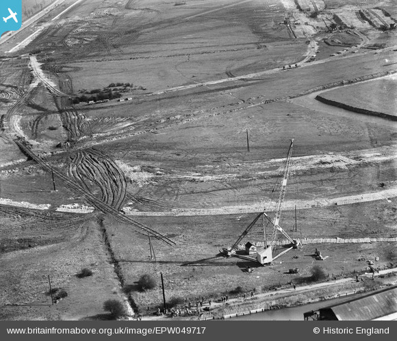
EPW049717 ENGLAND (1936). The site of the northern end of the William Girling Reservoir showing preliminary construction works, Ponders End, 1936
© Copyright OpenStreetMap contributors and licensed by the OpenStreetMap Foundation. 2026. Cartography is licensed as CC BY-SA.
Nearby Images (18)
Details
| Title | [EPW049717] The site of the northern end of the William Girling Reservoir showing preliminary construction works, Ponders End, 1936 |
| Reference | EPW049717 |
| Date | March-1936 |
| Link | |
| Place name | PONDERS END |
| Parish | |
| District | |
| Country | ENGLAND |
| Easting / Northing | 536473, 195235 |
| Longitude / Latitude | -0.027613258012802, 51.638872023757 |
| National Grid Reference | TQ365952 |
Pins
Be the first to add a comment to this image!


![[EPW049717] The site of the northern end of the William Girling Reservoir showing preliminary construction works, Ponders End, 1936](http://britainfromabove.org.uk/sites/all/libraries/aerofilms-images/public/100x100/EPW/049/EPW049717.jpg)
![[EAW042858] Riverside Industrial Estate, Ponders End, 1952. This image was marked by Aerofilms Ltd for photo editing.](http://britainfromabove.org.uk/sites/all/libraries/aerofilms-images/public/100x100/EAW/042/EAW042858.jpg)
![[EAW042860] Riverside Industrial Estate, Ponders End, 1952. This image was marked by Aerofilms Ltd for photo editing.](http://britainfromabove.org.uk/sites/all/libraries/aerofilms-images/public/100x100/EAW/042/EAW042860.jpg)
![[EPW049697] The site of the northern end of the William Girling Reservoir showing preliminary construction works, Ponders End, 1936](http://britainfromabove.org.uk/sites/all/libraries/aerofilms-images/public/100x100/EPW/049/EPW049697.jpg)
![[EAW042864] Riverside Industrial Estate, Ponders End, 1952. This image was marked by Aerofilms Ltd for photo editing.](http://britainfromabove.org.uk/sites/all/libraries/aerofilms-images/public/100x100/EAW/042/EAW042864.jpg)
![[EPW058466] The northern part of the Chingford (William Girling) Reservoir under construction, Edmonton, 1938](http://britainfromabove.org.uk/sites/all/libraries/aerofilms-images/public/100x100/EPW/058/EPW058466.jpg)
![[EPW049713] The site of the northern end of the William Girling Reservoir showing preliminary construction works, Ponders End, 1936](http://britainfromabove.org.uk/sites/all/libraries/aerofilms-images/public/100x100/EPW/049/EPW049713.jpg)
![[EPW056827] The northern end of the William Girling Reservoir under construction, Ponders End, 1938](http://britainfromabove.org.uk/sites/all/libraries/aerofilms-images/public/100x100/EPW/056/EPW056827.jpg)
![[EAW042868] Riverside Industrial Estate and environs, Ponders End, 1952. This image was marked by Aerofilms Ltd for photo editing.](http://britainfromabove.org.uk/sites/all/libraries/aerofilms-images/public/100x100/EAW/042/EAW042868.jpg)
![[EPW049719] The site of the northern end of the William Girling Reservoir showing preliminary construction works, Ponders End, 1936](http://britainfromabove.org.uk/sites/all/libraries/aerofilms-images/public/100x100/EPW/049/EPW049719.jpg)
![[EAW035936] The Tap & Die Corporation Ltd Warrior Works on the Riverside Industrial Estate, Ponders End, 1951. This image has been produced from a print marked by Aerofilms Ltd for photo editing.](http://britainfromabove.org.uk/sites/all/libraries/aerofilms-images/public/100x100/EAW/035/EAW035936.jpg)
![[EPW060637] Lea Valley Road, King George's Reservoir and the William Girling Reservoir under construction, Enfield, 1939](http://britainfromabove.org.uk/sites/all/libraries/aerofilms-images/public/100x100/EPW/060/EPW060637.jpg)
![[EAW035935] The Tap & Die Corporation Ltd Warrior Works on the Riverside Industrial Estate, Ponders End, 1951. This image has been produced from a print marked by Aerofilms Ltd for photo editing.](http://britainfromabove.org.uk/sites/all/libraries/aerofilms-images/public/100x100/EAW/035/EAW035935.jpg)
![[EPW048904] The southern end of King George's Reservoir, the Charlotte Cabinet Works and Lea Valley Road, Ponders End, 1935](http://britainfromabove.org.uk/sites/all/libraries/aerofilms-images/public/100x100/EPW/048/EPW048904.jpg)
![[EAW035941] The Tap & Die Corporation Ltd Warrior Works on the Riverside Industrial Estate, Ponders End, 1951. This image has been produced from a print marked by Aerofilms Ltd for photo editing.](http://britainfromabove.org.uk/sites/all/libraries/aerofilms-images/public/100x100/EAW/035/EAW035941.jpg)
![[EAW035940] The Tap & Die Corporation Ltd Warrior Works on the Riverside Industrial Estate, Ponders End, 1951. This image has been produced from a print marked by Aerofilms Ltd for photo editing.](http://britainfromabove.org.uk/sites/all/libraries/aerofilms-images/public/100x100/EAW/035/EAW035940.jpg)
![[EAW035938] The Tap & Die Corporation Ltd Warrior Works on the Riverside Industrial Estate, Ponders End, 1951. This image has been produced from a print marked by Aerofilms Ltd for photo editing.](http://britainfromabove.org.uk/sites/all/libraries/aerofilms-images/public/100x100/EAW/035/EAW035938.jpg)
![[EPW060224] The Chingford (William Girling) Reservoir under construction, Edmonton, from the north, 1938](http://britainfromabove.org.uk/sites/all/libraries/aerofilms-images/public/100x100/EPW/060/EPW060224.jpg)