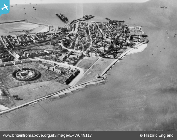
EPW049117 ENGLAND (1935). The Outer Part of Town Eastward and Tower Hill, Harwich, 1935. This image has been produced from a copy-negative.
© Copyright OpenStreetMap contributors and licensed by the OpenStreetMap Foundation. 2026. Cartography is licensed as CC BY-SA.
Details
| Title | [EPW049117] The Outer Part of Town Eastward and Tower Hill, Harwich, 1935. This image has been produced from a copy-negative. |
| Reference | EPW049117 |
| Date | August-1935 |
| Link | |
| Place name | HARWICH |
| Parish | HARWICH |
| District | |
| Country | ENGLAND |
| Easting / Northing | 626219, 232349 |
| Longitude / Latitude | 1.2918067675979, 51.943135003058 |
| National Grid Reference | TM262323 |
Pins

Maurice |
Wednesday 21st of January 2015 07:10:35 AM | |

Maurice |
Wednesday 21st of January 2015 07:08:42 AM | |

Maurice |
Wednesday 21st of January 2015 07:08:12 AM | |

Maurice |
Wednesday 21st of January 2015 06:57:20 AM |


![[EPW049117] The Outer Part of Town Eastward and Tower Hill, Harwich, 1935. This image has been produced from a copy-negative.](http://britainfromabove.org.uk/sites/all/libraries/aerofilms-images/public/100x100/EPW/049/EPW049117.jpg)
![[EPW049039] The Outer Part of Town Eastward, Tower Hill and environs, Harwich, 1935. This image has been produced from a copy-negative.](http://britainfromabove.org.uk/sites/all/libraries/aerofilms-images/public/100x100/EPW/049/EPW049039.jpg)
![[EAW048287] Flooding at Bath Side, Harwich, 1953](http://britainfromabove.org.uk/sites/all/libraries/aerofilms-images/public/100x100/EAW/048/EAW048287.jpg)
![[EPW039288] St Nicholas's Church and the town, Harwich, 1932](http://britainfromabove.org.uk/sites/all/libraries/aerofilms-images/public/100x100/EPW/039/EPW039288.jpg)