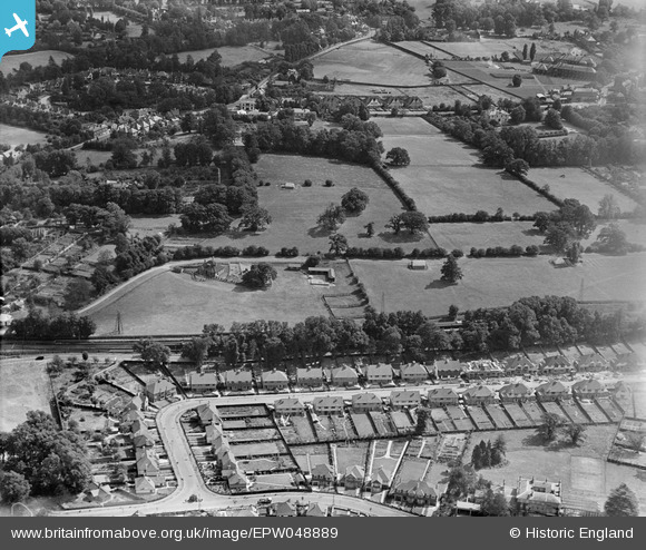
EPW048889 ENGLAND (1935). Housing under construction along Hookfield and adjacent fields, Epsom, 1935
© Copyright OpenStreetMap contributors and licensed by the OpenStreetMap Foundation. 2026. Cartography is licensed as CC BY-SA.
Nearby Images (8)
Details
| Title | [EPW048889] Housing under construction along Hookfield and adjacent fields, Epsom, 1935 |
| Reference | EPW048889 |
| Date | August-1935 |
| Link | |
| Place name | EPSOM |
| Parish | |
| District | |
| Country | ENGLAND |
| Easting / Northing | 520333, 160521 |
| Longitude / Latitude | -0.27258846686075, 51.330533938571 |
| National Grid Reference | TQ203605 |
Pins

Ian Ormiston Stables |
Tuesday 9th of May 2017 10:55:32 AM |


![[EPW048889] Housing under construction along Hookfield and adjacent fields, Epsom, 1935](http://britainfromabove.org.uk/sites/all/libraries/aerofilms-images/public/100x100/EPW/048/EPW048889.jpg)
![[EPW048883] Fields to the west of the town, Epsom, 1935](http://britainfromabove.org.uk/sites/all/libraries/aerofilms-images/public/100x100/EPW/048/EPW048883.jpg)
![[EPW048880] Fields to the west of the town, Epsom, 1935](http://britainfromabove.org.uk/sites/all/libraries/aerofilms-images/public/100x100/EPW/048/EPW048880.jpg)
![[EPW048886] Housing under construction along Hookfield and adjacent fields, Epsom, 1935](http://britainfromabove.org.uk/sites/all/libraries/aerofilms-images/public/100x100/EPW/048/EPW048886.jpg)
![[EPW048884] Fields to the west of the town, Epsom, 1935](http://britainfromabove.org.uk/sites/all/libraries/aerofilms-images/public/100x100/EPW/048/EPW048884.jpg)
![[EPW048885] White Horse Drive, Dudley Grove and adjacent fields, Epsom, 1935](http://britainfromabove.org.uk/sites/all/libraries/aerofilms-images/public/100x100/EPW/048/EPW048885.jpg)
![[EPW048888] Abele Grove (home to the Convent of the Sacred Heart), and adjacent fields, Epsom, 1935](http://britainfromabove.org.uk/sites/all/libraries/aerofilms-images/public/100x100/EPW/048/EPW048888.jpg)
![[EPW048890] Fields to the west of the town, Epsom, 1935](http://britainfromabove.org.uk/sites/all/libraries/aerofilms-images/public/100x100/EPW/048/EPW048890.jpg)