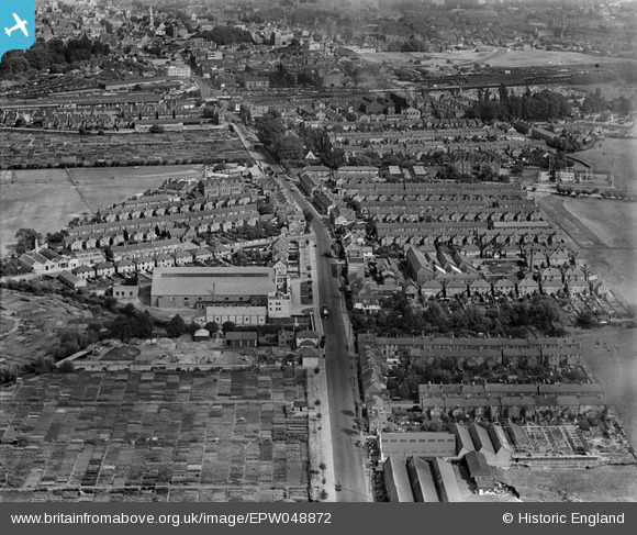
EPW048872 ENGLAND (1935). Botley Road and environs, Oxford, 1935
    © Copyright OpenStreetMap contributors and licensed by the OpenStreetMap Foundation. 2025. Cartography is licensed as CC BY-SA.
  
Nearby Images (5)
Details
| Title | [EPW048872] Botley Road and environs, Oxford, 1935 | 
| Reference | EPW048872 | 
| Date | August-1935 | 
| Link | |
| Place name | OXFORD | 
| Parish | |
| District | |
| Country | ENGLAND | 
| Easting / Northing | 449882, 206209 | 
| Longitude / Latitude | -1.2773066568899, 51.751896485568 | 
| National Grid Reference | SP499062 | 
Pins
Be the first to add a comment to this image!
 
             
  ![[EPW048872] Botley Road and environs, Oxford, 1935](http://britainfromabove.org.uk/sites/all/libraries/aerofilms-images/public/100x100/EPW/048/EPW048872.jpg) 
  
                                          ![[EPW048873] Botley Road and the city, Oxford, from the west, 1935](http://britainfromabove.org.uk/sites/all/libraries/aerofilms-images/public/100x100/EPW/048/EPW048873.jpg) 
 ![[EPW048871] Botley Road and environs, Oxford, 1935](http://britainfromabove.org.uk/sites/all/libraries/aerofilms-images/public/100x100/EPW/048/EPW048871.jpg) 
 ![[EPW048869] Botley Road and the city, Oxford, from the south-west, 1935](http://britainfromabove.org.uk/sites/all/libraries/aerofilms-images/public/100x100/EPW/048/EPW048869.jpg) 
 ![[EPW048870] Botley Road and the city, Oxford, from the west, 1935](http://britainfromabove.org.uk/sites/all/libraries/aerofilms-images/public/100x100/EPW/048/EPW048870.jpg)