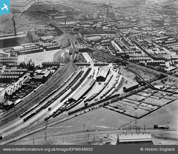
EPW048652 ENGLAND (1935). Radcliffe New Station, adjacent goods station and environs, Radcliffe, 1935
© Copyright OpenStreetMap contributors and licensed by the OpenStreetMap Foundation. 2026. Cartography is licensed as CC BY-SA.
Nearby Images (19)
Details
| Title | [EPW048652] Radcliffe New Station, adjacent goods station and environs, Radcliffe, 1935 |
| Reference | EPW048652 |
| Date | July-1935 |
| Link | |
| Place name | RADCLIFFE |
| Parish | |
| District | |
| Country | ENGLAND |
| Easting / Northing | 378766, 407494 |
| Longitude / Latitude | -2.320624317469, 53.563388983254 |
| National Grid Reference | SD788075 |
Pins

Moonraker |
Sunday 29th of October 2023 08:48:15 PM | |

K |
Wednesday 15th of January 2020 11:30:43 PM | |

K |
Wednesday 15th of January 2020 11:28:54 PM | |

K |
Wednesday 15th of January 2020 11:26:53 PM | |

K |
Wednesday 15th of January 2020 11:24:50 PM | |

K |
Wednesday 15th of January 2020 11:23:09 PM | |

K |
Wednesday 15th of January 2020 11:22:19 PM | |

K |
Wednesday 15th of January 2020 11:16:17 PM | |

K |
Wednesday 15th of January 2020 11:14:04 PM | |

K |
Wednesday 15th of January 2020 11:11:27 PM | |

K |
Wednesday 15th of January 2020 11:08:49 PM | |

Andy Williams |
Monday 31st of March 2014 07:46:43 PM |
User Comment Contributions
The rail track on the left is now the Manchester Metro Tram system, the track to the right is long gone |

wadey |
Sunday 25th of August 2013 11:15:58 PM |


![[EPW048652] Radcliffe New Station, adjacent goods station and environs, Radcliffe, 1935](http://britainfromabove.org.uk/sites/all/libraries/aerofilms-images/public/100x100/EPW/048/EPW048652.jpg)
![[EPW048655] Radcliffe New Station, adjacent goods station and environs, Radcliffe, 1935](http://britainfromabove.org.uk/sites/all/libraries/aerofilms-images/public/100x100/EPW/048/EPW048655.jpg)
![[EPW048651] Radcliffe New Station, adjacent goods station and environs, Radcliffe, 1935](http://britainfromabove.org.uk/sites/all/libraries/aerofilms-images/public/100x100/EPW/048/EPW048651.jpg)
![[EPW048654] Radcliffe New Station, adjacent goods station and environs, Radcliffe, 1935](http://britainfromabove.org.uk/sites/all/libraries/aerofilms-images/public/100x100/EPW/048/EPW048654.jpg)
![[EPW048647] Radcliffe New Station, adjacent goods station and environs, Radcliffe, 1935](http://britainfromabove.org.uk/sites/all/libraries/aerofilms-images/public/100x100/EPW/048/EPW048647.jpg)
![[EPW047484] The Goods Station, West Junction and environs, Radcliffe, from the south-east, 1935](http://britainfromabove.org.uk/sites/all/libraries/aerofilms-images/public/100x100/EPW/047/EPW047484.jpg)
![[EPW048649] Radcliffe New Station, adjacent goods station and environs, Radcliffe, 1935](http://britainfromabove.org.uk/sites/all/libraries/aerofilms-images/public/100x100/EPW/048/EPW048649.jpg)
![[EAW051420] The Associated Sprinkler Co Ltd Works (Globe Iron Works) and Radcliffe Goods Yard, Radcliffe, 1953. This image was marked by Aerofilms Ltd for photo editing.](http://britainfromabove.org.uk/sites/all/libraries/aerofilms-images/public/100x100/EAW/051/EAW051420.jpg)
![[EPW047489] The Goods Station, West Junction and environs, Radcliffe, from the east, 1935](http://britainfromabove.org.uk/sites/all/libraries/aerofilms-images/public/100x100/EPW/047/EPW047489.jpg)
![[EAW051416] The Associated Sprinkler Co Ltd Works (Globe Iron Works) and Spring Lane, Radcliffe, 1953. This image was marked by Aerofilms Ltd for photo editing.](http://britainfromabove.org.uk/sites/all/libraries/aerofilms-images/public/100x100/EAW/051/EAW051416.jpg)
![[EAW008446] Good Yards beside Radcliffe East Fork (railway) and the East Lancashire Paper Mill, Radcliffe, from the west, 1947. This image was marked by Aerofilms Ltd for photo editing.](http://britainfromabove.org.uk/sites/all/libraries/aerofilms-images/public/100x100/EAW/008/EAW008446.jpg)
![[EAW051414] The Associated Sprinkler Co Ltd Works (Globe Iron Works), Radcliffe, 1953. This image was marked by Aerofilms Ltd for photo editing.](http://britainfromabove.org.uk/sites/all/libraries/aerofilms-images/public/100x100/EAW/051/EAW051414.jpg)
![[EAW051417] The Associated Sprinkler Co Ltd Works (Globe Iron Works) and Grey Street, Radcliffe, 1953. This image was marked by Aerofilms Ltd for photo editing.](http://britainfromabove.org.uk/sites/all/libraries/aerofilms-images/public/100x100/EAW/051/EAW051417.jpg)
![[EAW051415] The Associated Sprinkler Co Ltd Works (Globe Iron Works), Radcliffe, 1953. This image was marked by Aerofilms Ltd for photo editing.](http://britainfromabove.org.uk/sites/all/libraries/aerofilms-images/public/100x100/EAW/051/EAW051415.jpg)
![[EAW051412] The Associated Sprinkler Co Ltd Works (Globe Iron Works) and Grey Street, Radcliffe, 1953. This image was marked by Aerofilms Ltd for photo editing.](http://britainfromabove.org.uk/sites/all/libraries/aerofilms-images/public/100x100/EAW/051/EAW051412.jpg)
![[EAW051419] The Associated Sprinkler Co Ltd Works (Globe Iron Works), Radcliffe, 1953. This image was marked by Aerofilms Ltd for photo editing.](http://britainfromabove.org.uk/sites/all/libraries/aerofilms-images/public/100x100/EAW/051/EAW051419.jpg)
![[EAW051413] The Associated Sprinkler Co Ltd Works (Globe Iron Works), Radcliffe, 1953. This image was marked by Aerofilms Ltd for photo editing.](http://britainfromabove.org.uk/sites/all/libraries/aerofilms-images/public/100x100/EAW/051/EAW051413.jpg)
![[EAW051418] The Associated Sprinkler Co Ltd Works (Globe Iron Works) and Spring Lane, Radcliffe, 1953. This image was marked by Aerofilms Ltd for photo editing.](http://britainfromabove.org.uk/sites/all/libraries/aerofilms-images/public/100x100/EAW/051/EAW051418.jpg)
![[EPW047485] West Junction, North Junction and environs, Radcliffe, from the south-east, 1935](http://britainfromabove.org.uk/sites/all/libraries/aerofilms-images/public/100x100/EPW/047/EPW047485.jpg)