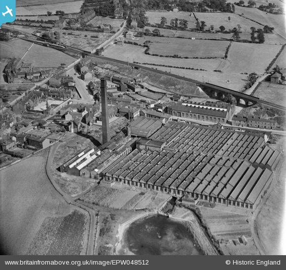
EPW048512 ENGLAND (1935). The Alverthorpe Woollen Mills, Alverthorpe, 1935
    © Copyright OpenStreetMap contributors and licensed by the OpenStreetMap Foundation. 2025. Cartography is licensed as CC BY-SA.
  
Nearby Images (6)
Details
| Title | [EPW048512] The Alverthorpe Woollen Mills, Alverthorpe, 1935 | 
| Reference | EPW048512 | 
| Date | July-1935 | 
| Link | |
| Place name | ALVERTHORPE | 
| Parish | |
| District | |
| Country | ENGLAND | 
| Easting / Northing | 431002, 421420 | 
| Longitude / Latitude | -1.530500305238, 53.688083166939 | 
| National Grid Reference | SE310214 | 
Pins
|   Michael | Sunday 17th of November 2019 02:07:33 PM | 
 
             
  ![[EPW048512] The Alverthorpe Woollen Mills, Alverthorpe, 1935](http://britainfromabove.org.uk/sites/all/libraries/aerofilms-images/public/100x100/EPW/048/EPW048512.jpg) 
  
                                          ![[EPW048518] The Alverthorpe Woollen Mill, Alverthorpe, 1935](http://britainfromabove.org.uk/sites/all/libraries/aerofilms-images/public/100x100/EPW/048/EPW048518.jpg) 
 ![[EPW048517] The Alverthorpe Woollen Mill and St Paul's Church, Alverthorpe, 1935](http://britainfromabove.org.uk/sites/all/libraries/aerofilms-images/public/100x100/EPW/048/EPW048517.jpg) 
 ![[EPW048519] The Alverthorpe Woollen Mill, Alverthorpe, 1935](http://britainfromabove.org.uk/sites/all/libraries/aerofilms-images/public/100x100/EPW/048/EPW048519.jpg) 
 ![[EPW048516] The Alverthorpe Woollen Mill and environs, Alverthorpe, 1935](http://britainfromabove.org.uk/sites/all/libraries/aerofilms-images/public/100x100/EPW/048/EPW048516.jpg) 
 ![[EPW048514] The Alverthorpe Woollen Mill and surrounding countryside, Alverthorpe, 1935](http://britainfromabove.org.uk/sites/all/libraries/aerofilms-images/public/100x100/EPW/048/EPW048514.jpg) 
 
 Alverthorpe Railway Station (1872-1954) GNR
 Alverthorpe Railway Station (1872-1954) GNR