
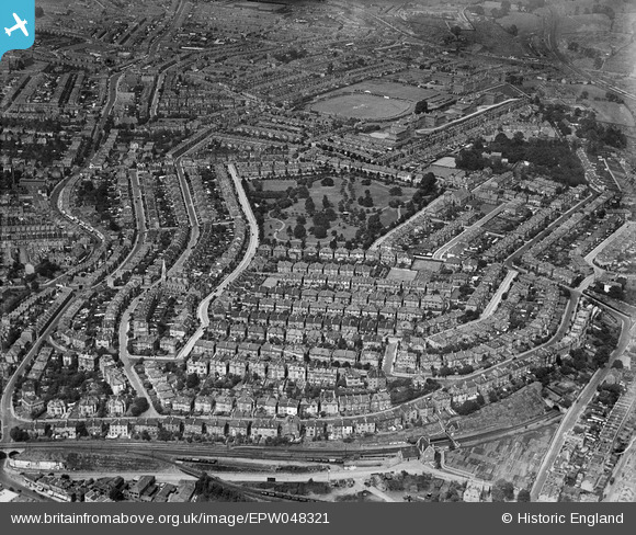
EPW048321 ENGLAND (1935). St Andrew's Park, the County Cricket Ground and the surrounding residential area, Montpelier, 1935
© Copyright OpenStreetMap contributors and licensed by the OpenStreetMap Foundation. 2026. Cartography is licensed as CC BY-SA.
Nearby Images (4)
EPW048321

EPW048322

EPW048320

EPW048319

Details
| Title | [EPW048321] St Andrew's Park, the County Cricket Ground and the surrounding residential area, Montpelier, 1935 |
| Reference | EPW048321 |
| Date | July-1935 |
| Link | |
| Place name | MONTPELIER |
| Parish | |
| District | |
| Country | ENGLAND |
| Easting / Northing | 359262, 174924 |
| Longitude / Latitude | -2.5865857439068, 51.471325960432 |
| National Grid Reference | ST593749 |
Pins

Class31 |
Wednesday 26th of February 2014 11:32:48 PM | |
|
Class31 |
Wednesday 26th of February 2014 11:30:10 PM | |
|
Class31 |
Wednesday 26th of February 2014 11:29:47 PM | |
|
Class31 |
Wednesday 26th of February 2014 11:28:41 PM | |
|
Class31 |
Wednesday 26th of February 2014 11:28:01 PM | |
|
Class31 |
Wednesday 26th of February 2014 11:27:27 PM | |
|
Class31 |
Wednesday 26th of February 2014 11:26:37 PM | |
|
Class31 |
Wednesday 26th of February 2014 11:25:32 PM | |
|
Class31 |
Wednesday 26th of February 2014 11:23:31 PM |
User Comment Contributions
View looking north. |
Class31 |
Wednesday 26th of February 2014 11:30:50 PM |