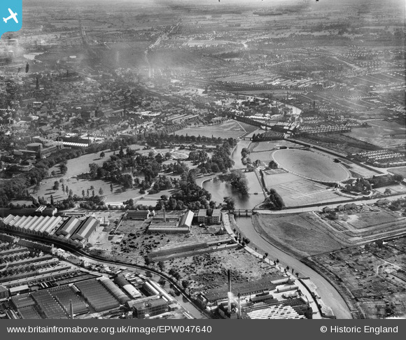
EPW047640 ENGLAND (1935). Abbey Park and environs, Leicester, from the north-east, 1935
© Copyright OpenStreetMap contributors and licensed by the OpenStreetMap Foundation. 2025. Cartography is licensed as CC BY-SA.
Nearby Images (13)
Details
| Title | [EPW047640] Abbey Park and environs, Leicester, from the north-east, 1935 |
| Reference | EPW047640 |
| Date | June-1935 |
| Link | |
| Place name | LEICESTER |
| Parish | |
| District | |
| Country | ENGLAND |
| Easting / Northing | 458794, 306079 |
| Longitude / Latitude | -1.130861598207, 52.648905077738 |
| National Grid Reference | SK588061 |
Pins
Be the first to add a comment to this image!


![[EPW047640] Abbey Park and environs, Leicester, from the north-east, 1935](http://britainfromabove.org.uk/sites/all/libraries/aerofilms-images/public/100x100/EPW/047/EPW047640.jpg)
![[EAW010423] T.G. Hirst & Co Ltd Fancy Hosiery Factory, Abbey Park, 1947. This image was marked by Aerofilms Ltd for photo editing.](http://britainfromabove.org.uk/sites/all/libraries/aerofilms-images/public/100x100/EAW/010/EAW010423.jpg)
![[EAW010418] T.G. Hirst & Co Ltd Fancy Hosiery Factory, Abbey Park, 1947. This image was marked by Aerofilms Ltd for photo editing.](http://britainfromabove.org.uk/sites/all/libraries/aerofilms-images/public/100x100/EAW/010/EAW010418.jpg)
![[EAW010420] T.G. Hirst & Co Ltd Fancy Hosiery Factory, Abbey Park, 1947. This image was marked by Aerofilms Ltd for photo editing.](http://britainfromabove.org.uk/sites/all/libraries/aerofilms-images/public/100x100/EAW/010/EAW010420.jpg)
![[EAW010417] T.G. Hirst & Co Ltd Fancy Hosiery Factory and environs, Abbey Park, 1947. This image was marked by Aerofilms Ltd for photo editing.](http://britainfromabove.org.uk/sites/all/libraries/aerofilms-images/public/100x100/EAW/010/EAW010417.jpg)
![[EAW010421] T.G. Hirst & Co Ltd Fancy Hosiery Factory and environs, Abbey Park, 1947. This image was marked by Aerofilms Ltd for photo editing.](http://britainfromabove.org.uk/sites/all/libraries/aerofilms-images/public/100x100/EAW/010/EAW010421.jpg)
![[EAW010422] T.G. Hirst & Co Ltd Fancy Hosiery Factory and environs, Abbey Park, 1947. This image was marked by Aerofilms Ltd for photo editing.](http://britainfromabove.org.uk/sites/all/libraries/aerofilms-images/public/100x100/EAW/010/EAW010422.jpg)
![[EAW010419] T.G. Hirst & Co Ltd Fancy Hosiery Factory and environs, Abbey Park, 1947. This image was marked by Aerofilms Ltd for photo editing.](http://britainfromabove.org.uk/sites/all/libraries/aerofilms-images/public/100x100/EAW/010/EAW010419.jpg)
![[EPW047639] Abbey Park and environs, Leicester, from the north-east, 1935](http://britainfromabove.org.uk/sites/all/libraries/aerofilms-images/public/100x100/EPW/047/EPW047639.jpg)
![[EAW010416] T.G. Hirst & Co Ltd Fancy Hosiery Factory on Abbey Park Road, Abbey Park, 1947. This image was marked by Aerofilms Ltd for photo editing.](http://britainfromabove.org.uk/sites/all/libraries/aerofilms-images/public/100x100/EAW/010/EAW010416.jpg)
![[EAW043362] The Abbey Grounds, the River Soar and the surrounding area, Leicester, 1952](http://britainfromabove.org.uk/sites/all/libraries/aerofilms-images/public/100x100/EAW/043/EAW043362.jpg)
![[EPW055013] Leicester Abbey, Leicester, 1937](http://britainfromabove.org.uk/sites/all/libraries/aerofilms-images/public/100x100/EPW/055/EPW055013.jpg)
![[EAW051825] Abbey Park and the site of Leicester Abbey, Leicester, 1953](http://britainfromabove.org.uk/sites/all/libraries/aerofilms-images/public/100x100/EAW/051/EAW051825.jpg)