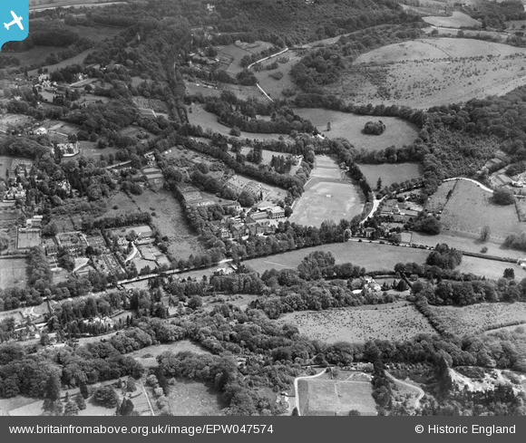
EPW047574 ENGLAND (1935). Caterham School and environs, Caterham, 1935
© Copyright OpenStreetMap contributors and licensed by the OpenStreetMap Foundation. 2025. Cartography is licensed as CC BY-SA.
Nearby Images (15)
Details
| Title | [EPW047574] Caterham School and environs, Caterham, 1935 |
| Reference | EPW047574 |
| Date | June-1935 |
| Link | |
| Place name | CATERHAM |
| Parish | CATERHAM VALLEY |
| District | |
| Country | ENGLAND |
| Easting / Northing | 533586, 154271 |
| Longitude / Latitude | -0.084786807750633, 51.271401028641 |
| National Grid Reference | TQ336543 |
Pins
 KiwiMike |
Wednesday 13th of April 2022 10:11:58 PM | |
 KiwiMike |
Wednesday 13th of April 2022 10:10:25 PM | |
 KiwiMike |
Wednesday 13th of April 2022 10:09:47 PM | |
 KiwiMike |
Wednesday 13th of April 2022 10:09:14 PM | |
 KiwiMike |
Wednesday 13th of April 2022 10:08:54 PM | |
 KiwiMike |
Sunday 17th of July 2016 11:44:12 AM |


![[EPW047574] Caterham School and environs, Caterham, 1935](http://britainfromabove.org.uk/sites/all/libraries/aerofilms-images/public/100x100/EPW/047/EPW047574.jpg)
![[EPW015633] Caterham School, Caterham, 1926. This image has been produced from a print.](http://britainfromabove.org.uk/sites/all/libraries/aerofilms-images/public/100x100/EPW/015/EPW015633.jpg)
![[EPW047577] Caterham School, Caterham, 1935](http://britainfromabove.org.uk/sites/all/libraries/aerofilms-images/public/100x100/EPW/047/EPW047577.jpg)
![[EPW047575] Caterham School, Caterham, 1935](http://britainfromabove.org.uk/sites/all/libraries/aerofilms-images/public/100x100/EPW/047/EPW047575.jpg)
![[EPW047576] Caterham School, Caterham, 1935](http://britainfromabove.org.uk/sites/all/libraries/aerofilms-images/public/100x100/EPW/047/EPW047576.jpg)
![[EPW047567] Caterham School, Caterham, 1935](http://britainfromabove.org.uk/sites/all/libraries/aerofilms-images/public/100x100/EPW/047/EPW047567.jpg)
![[EPW047569] Caterham School, Caterham, 1935](http://britainfromabove.org.uk/sites/all/libraries/aerofilms-images/public/100x100/EPW/047/EPW047569.jpg)
![[EPW047568] Caterham School, Caterham, 1935](http://britainfromabove.org.uk/sites/all/libraries/aerofilms-images/public/100x100/EPW/047/EPW047568.jpg)
![[EPW015636] Caterham School, Caterham, 1926](http://britainfromabove.org.uk/sites/all/libraries/aerofilms-images/public/100x100/EPW/015/EPW015636.jpg)
![[EPW047570] Caterham School, Caterham, 1935](http://britainfromabove.org.uk/sites/all/libraries/aerofilms-images/public/100x100/EPW/047/EPW047570.jpg)
![[EPW047573] Caterham School and environs, Caterham, 1935](http://britainfromabove.org.uk/sites/all/libraries/aerofilms-images/public/100x100/EPW/047/EPW047573.jpg)
![[EPW047571] Caterham School, Caterham, 1935](http://britainfromabove.org.uk/sites/all/libraries/aerofilms-images/public/100x100/EPW/047/EPW047571.jpg)
![[EPW047572] Caterham School and environs, Caterham, 1935](http://britainfromabove.org.uk/sites/all/libraries/aerofilms-images/public/100x100/EPW/047/EPW047572.jpg)
![[EPW015632] Caterham School, Caterham, 1926](http://britainfromabove.org.uk/sites/all/libraries/aerofilms-images/public/100x100/EPW/015/EPW015632.jpg)
![[EPW015638] Caterham School, Caterham, 1926](http://britainfromabove.org.uk/sites/all/libraries/aerofilms-images/public/100x100/EPW/015/EPW015638.jpg)