
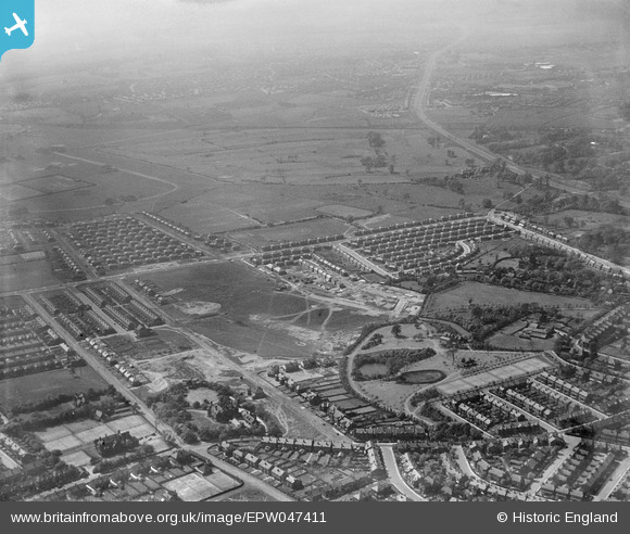
EPW047411 ENGLAND (1935). Light Oaks Park, housing under construction along Burnside Avenue and environs, Salford, from the east, 1935
© Copyright OpenStreetMap contributors and licensed by the OpenStreetMap Foundation. 2026. Cartography is licensed as CC BY-SA.
Nearby Images (6)
EPW047411

EPW047403

EPW047408

EPW047407

EPW047404

EPW047406

Details
| Title | [EPW047411] Light Oaks Park, housing under construction along Burnside Avenue and environs, Salford, from the east, 1935 |
| Reference | EPW047411 |
| Date | May-1935 |
| Link | |
| Place name | SALFORD |
| Parish | |
| District | |
| Country | ENGLAND |
| Easting / Northing | 379197, 400024 |
| Longitude / Latitude | -2.3136200213511, 53.496256314819 |
| National Grid Reference | SD792000 |
Pins

Lizzie |
Tuesday 3rd of October 2023 07:48:37 PM | |
|
Lizzie |
Sunday 24th of September 2023 09:23:11 PM | |
|
Lizzie |
Sunday 24th of September 2023 09:21:53 PM | |
|
Lizzie |
Sunday 24th of September 2023 09:21:20 PM | |
|
Lizzie |
Sunday 24th of September 2023 09:21:05 PM | |

I Sharratt |
Friday 2nd of April 2021 06:46:05 AM | |
|
I Sharratt |
Friday 2nd of April 2021 06:45:10 AM | |
|
I Sharratt |
Friday 2nd of April 2021 06:43:01 AM | |
|
I Sharratt |
Friday 2nd of April 2021 06:42:18 AM | |
|
Simon C |
Tuesday 14th of November 2017 12:49:45 PM | |
Chomlea was built for Benjamin Armitage MP in 1883. It was converted into flats in the 1940’s and was demolished to make way for the Chomlea Manor housing estate. More here: https://manchestervictorianarchitects.org.uk/buildings/chomlea-claremont-road-salford |

Duneane |
Friday 27th of May 2022 10:47:42 AM |
|
Ian Ashton |
Monday 2nd of December 2013 09:58:08 PM | |
That was the school playing fields; the Old Boys played (in the 50s/ 60s) in Light Oaks Park. |
Maitland |
Saturday 18th of January 2014 09:28:49 PM |