
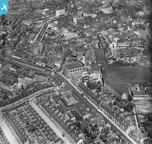
EPW047172 ENGLAND (1935). The A C Wickman Ltd Engineering Works alongside Queen Victoria Road and the city centre, Coventry, 1935

© Copyright OpenStreetMap contributors and licensed by the OpenStreetMap Foundation. 2026. Cartography is licensed as CC BY-SA.
Nearby Images (17)
EPW047172

EPW047170

EPW047168

EPW047171

EPW047169

EPW047174

EPW061109

EPW047173

EPW001199

EPW061111

EPW001202

EPW035763

EAW030281

EAW001833

EAW024988

EPW001197

EAW030280

Details
| Title | [EPW047172] The A C Wickman Ltd Engineering Works alongside Queen Victoria Road and the city centre, Coventry, 1935 |
| Reference | EPW047172 |
| Date | May-1935 |
| Link | |
| Place name | COVENTRY |
| Parish | |
| District | |
| Country | ENGLAND |
| Easting / Northing | 433071, 278855 |
| Longitude / Latitude | -1.5138083868552, 52.406323516256 |
| National Grid Reference | SP331789 |
Pins

John |
Monday 20th of May 2019 01:48:47 PM | |
|
rowles |
Monday 28th of December 2015 10:56:37 PM | |
|
rowles |
Monday 28th of December 2015 10:54:28 PM | |
|
Nat |
Friday 27th of September 2013 04:15:28 PM | |
|
Nat |
Friday 27th of September 2013 04:12:56 PM | |
|
Nat |
Friday 27th of September 2013 04:12:10 PM | |
|
Nat |
Friday 27th of September 2013 04:11:45 PM |
User Comment Contributions
View more to the north with Corporation Street in the background. May 1935. EPW047172 |
Nat |
Friday 27th of September 2013 04:22:27 PM |