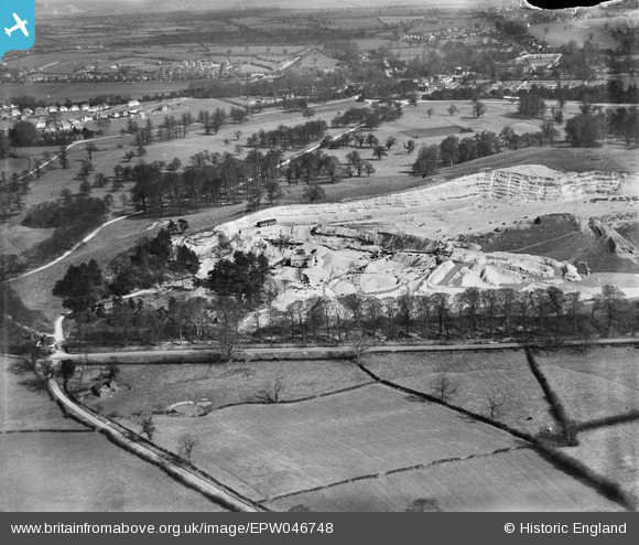
EPW046748 ENGLAND (1935). Trentham Gravel Pit and environs, Hanchurch, 1935
© Copyright OpenStreetMap contributors and licensed by the OpenStreetMap Foundation. 2024. Cartography is licensed as CC BY-SA.
Nearby Images (8)
Details
| Title | [EPW046748] Trentham Gravel Pit and environs, Hanchurch, 1935 |
| Reference | EPW046748 |
| Date | March-1935 |
| Link | |
| Place name | HANCHURCH |
| Parish | SWYNNERTON |
| District | |
| Country | ENGLAND |
| Easting / Northing | 385305, 340609 |
| Longitude / Latitude | -2.2187985062476, 52.96233323143 |
| National Grid Reference | SJ853406 |
Pins
 Brittany |
Wednesday 24th of February 2021 07:10:24 PM |


![[EPW046748] Trentham Gravel Pit and environs, Hanchurch, 1935](http://britainfromabove.org.uk/sites/all/libraries/aerofilms-images/public/100x100/EPW/046/EPW046748.jpg)
![[EPW046750] Trentham Gravel Pit and environs, Hanchurch, 1935](http://britainfromabove.org.uk/sites/all/libraries/aerofilms-images/public/100x100/EPW/046/EPW046750.jpg)
![[EPW046751] Trentham Gravel Pit and environs, Hanchurch, 1935](http://britainfromabove.org.uk/sites/all/libraries/aerofilms-images/public/100x100/EPW/046/EPW046751.jpg)
![[EPW046745] Trentham Gravel Pit, Hanchurch, 1935](http://britainfromabove.org.uk/sites/all/libraries/aerofilms-images/public/100x100/EPW/046/EPW046745.jpg)
![[EPW046747] Trentham Gravel Pit, Hanchurch, 1935](http://britainfromabove.org.uk/sites/all/libraries/aerofilms-images/public/100x100/EPW/046/EPW046747.jpg)
![[EPW045283] The Trentham Gravel Co Gravel Pit and Trentham Gardens, Hanchurch, 1934. This image has been affected by flare.](http://britainfromabove.org.uk/sites/all/libraries/aerofilms-images/public/100x100/EPW/045/EPW045283.jpg)
![[EPW046749] Trentham Gravel Pit and environs, Hanchurch, 1935](http://britainfromabove.org.uk/sites/all/libraries/aerofilms-images/public/100x100/EPW/046/EPW046749.jpg)
![[EPW045289] The Trentham Gravel Co Gravel Pit, Kingswood Bank and surrounding countryside, Hanchurch, from the west, 1934](http://britainfromabove.org.uk/sites/all/libraries/aerofilms-images/public/100x100/EPW/045/EPW045289.jpg)