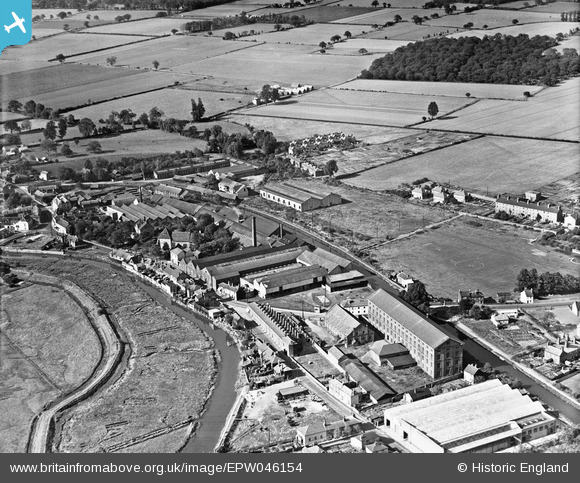
EPW046154 ENGLAND (1934). The E. H. Bentall and Co Works and environs, Heybridge, 1934
© Copyright OpenStreetMap contributors and licensed by the OpenStreetMap Foundation. 2026. Cartography is licensed as CC BY-SA.
Nearby Images (5)
Details
| Title | [EPW046154] The E. H. Bentall and Co Works and environs, Heybridge, 1934 |
| Reference | EPW046154 |
| Date | September-1934 |
| Link | |
| Place name | HEYBRIDGE |
| Parish | HEYBRIDGE |
| District | |
| Country | ENGLAND |
| Easting / Northing | 585597, 208169 |
| Longitude / Latitude | 0.68850540857505, 51.740987100251 |
| National Grid Reference | TL856082 |
Pins
Be the first to add a comment to this image!


![[EPW046154] The E. H. Bentall and Co Works and environs, Heybridge, 1934](http://britainfromabove.org.uk/sites/all/libraries/aerofilms-images/public/100x100/EPW/046/EPW046154.jpg)
![[EPW046159] The E. H. Bentall and Co Works and environs, Heybridge, 1934](http://britainfromabove.org.uk/sites/all/libraries/aerofilms-images/public/100x100/EPW/046/EPW046159.jpg)
![[EPW046160] The E. H. Bentall and Co Works and environs, Heybridge, 1934](http://britainfromabove.org.uk/sites/all/libraries/aerofilms-images/public/100x100/EPW/046/EPW046160.jpg)
![[EPW046158] The E. H. Bentall and Co Works and environs, Heybridge, from the north-west, 1934](http://britainfromabove.org.uk/sites/all/libraries/aerofilms-images/public/100x100/EPW/046/EPW046158.jpg)
![[EPW046157] The E. H. Bentall and Co Works and environs, Heybridge, from the north-west, 1934](http://britainfromabove.org.uk/sites/all/libraries/aerofilms-images/public/100x100/EPW/046/EPW046157.jpg)