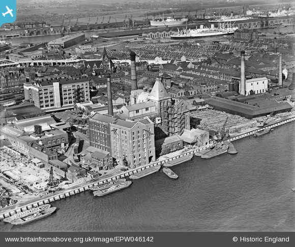
EPW046142 ENGLAND (1934). The Co-operative Wholesale Society and environs, Silvertown, 1934
© Copyright OpenStreetMap contributors and licensed by the OpenStreetMap Foundation. 2026. Cartography is licensed as CC BY-SA.
Nearby Images (20)
Details
| Title | [EPW046142] The Co-operative Wholesale Society and environs, Silvertown, 1934 |
| Reference | EPW046142 |
| Date | September-1934 |
| Link | |
| Place name | SILVERTOWN |
| Parish | |
| District | |
| Country | ENGLAND |
| Easting / Northing | 541752, 180018 |
| Longitude / Latitude | 0.042490624952424, 51.500816098982 |
| National Grid Reference | TQ418800 |
Pins
Be the first to add a comment to this image!


![[EPW046142] The Co-operative Wholesale Society and environs, Silvertown, 1934](http://britainfromabove.org.uk/sites/all/libraries/aerofilms-images/public/100x100/EPW/046/EPW046142.jpg)
![[EPW046144] The Co-operative Wholesale Society and environs, Silvertown, 1934](http://britainfromabove.org.uk/sites/all/libraries/aerofilms-images/public/100x100/EPW/046/EPW046144.jpg)
![[EPW046141] The Co-operative Wholesale Society and environs, Silvertown, 1934](http://britainfromabove.org.uk/sites/all/libraries/aerofilms-images/public/100x100/EPW/046/EPW046141.jpg)
![[EPW006147] The Co-Operative Wholesale Society Ltd, Silvertown, 1921](http://britainfromabove.org.uk/sites/all/libraries/aerofilms-images/public/100x100/EPW/006/EPW006147.jpg)
![[EPW006149] The India Rubber, Gutta Percha and Telegraph Works, Silvertown, 1921](http://britainfromabove.org.uk/sites/all/libraries/aerofilms-images/public/100x100/EPW/006/EPW006149.jpg)
![[EAW021111] A cityscape over the River Thames and the Royal Docks, Silvertown, 1949. This image has been produced from a print.](http://britainfromabove.org.uk/sites/all/libraries/aerofilms-images/public/100x100/EAW/021/EAW021111.jpg)
![[EPW006303] Co-operative Wholesale Society Works, Silvertown, 1921](http://britainfromabove.org.uk/sites/all/libraries/aerofilms-images/public/100x100/EPW/006/EPW006303.jpg)
![[EPW046139] The Co-operative Wholesale Society and environs, Silvertown, from the south, 1934](http://britainfromabove.org.uk/sites/all/libraries/aerofilms-images/public/100x100/EPW/046/EPW046139.jpg)
![[EPW046140] The Co-operative Wholesale Society and environs, Silvertown, from the south, 1934](http://britainfromabove.org.uk/sites/all/libraries/aerofilms-images/public/100x100/EPW/046/EPW046140.jpg)
![[EPW006577] T.W. Ward Ltd premises, Silvertown, 1921](http://britainfromabove.org.uk/sites/all/libraries/aerofilms-images/public/100x100/EPW/006/EPW006577.jpg)
![[EPW056669] Thomas W. Ward Ltd Works, Silvertown, 1938](http://britainfromabove.org.uk/sites/all/libraries/aerofilms-images/public/100x100/EPW/056/EPW056669.jpg)
![[EPW006578] T.W. Ward Ltd premises, Silvertown, 1921](http://britainfromabove.org.uk/sites/all/libraries/aerofilms-images/public/100x100/EPW/006/EPW006578.jpg)
![[EPW056670] Thomas W. Ward Ltd Works, Silvertown, 1938](http://britainfromabove.org.uk/sites/all/libraries/aerofilms-images/public/100x100/EPW/056/EPW056670.jpg)
![[EPW056673] Thomas W. Ward Ltd Works, Silvertown, 1938](http://britainfromabove.org.uk/sites/all/libraries/aerofilms-images/public/100x100/EPW/056/EPW056673.jpg)
![[EPW056671] Thomas W. Ward Ltd Works, Silvertown, 1938](http://britainfromabove.org.uk/sites/all/libraries/aerofilms-images/public/100x100/EPW/056/EPW056671.jpg)
![[EPW056672] Thomas W. Ward Ltd Works, Silvertown, 1938](http://britainfromabove.org.uk/sites/all/libraries/aerofilms-images/public/100x100/EPW/056/EPW056672.jpg)
![[EPW056667] Thomas W. Ward Ltd Works, Silvertown, 1938](http://britainfromabove.org.uk/sites/all/libraries/aerofilms-images/public/100x100/EPW/056/EPW056667.jpg)
![[EPW006579] T.W. Ward Ltd premises, Silvertown, 1921](http://britainfromabove.org.uk/sites/all/libraries/aerofilms-images/public/100x100/EPW/006/EPW006579.jpg)
![[EPW056668] Thomas W. Ward Ltd Works, Silvertown, 1938](http://britainfromabove.org.uk/sites/all/libraries/aerofilms-images/public/100x100/EPW/056/EPW056668.jpg)
![[EPW046143] The Co-operative Wholesale Society and environs, Silvertown, from the south-west, 1934](http://britainfromabove.org.uk/sites/all/libraries/aerofilms-images/public/100x100/EPW/046/EPW046143.jpg)