
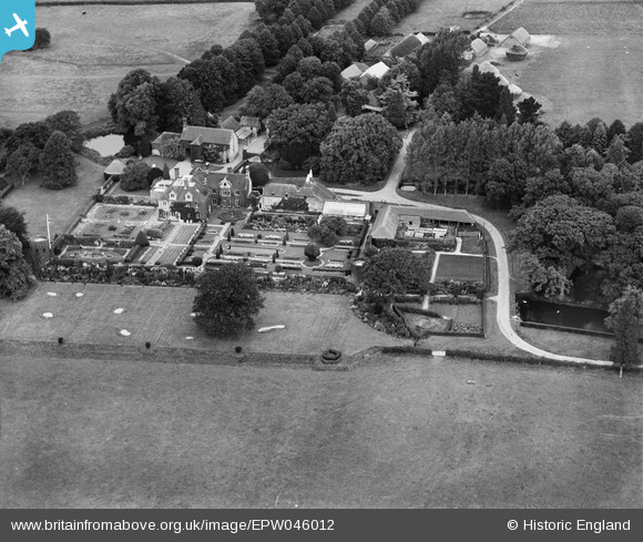
EPW046012 ENGLAND (1934). Isfield Place, Isfield, 1934
© Copyright OpenStreetMap contributors and licensed by the OpenStreetMap Foundation. 2026. Cartography is licensed as CC BY-SA.
Nearby Images (43)
EPW046012

EPW035187

EPW034503

EPW034502

EPW035176

EPW046007

EPW035189

EPW046010

EPW045481

EPW046011

EPW035177

EPW035178

EPW045477

EPW046008

EPW035174

EPW035188

EPW045473

EPW046009

EPW034506

EPW034498

EPW034507

EPW034501

EPW034509

EPW034508

EPW035186

EPW035185

EPW034500

EPW035182

EPW034504

EPW035175

EPW035181

EPW045479

EPW035183

EPW045480

EPW045476

EPW045478

EPW045474

EPW045472

EPW035179

EPW035180

EPW045475

EPW045471

EPW034499

Details
| Title | [EPW046012] Isfield Place, Isfield, 1934 |
| Reference | EPW046012 |
| Date | September-1934 |
| Link | |
| Place name | ISFIELD |
| Parish | ISFIELD |
| District | |
| Country | ENGLAND |
| Easting / Northing | 544668, 118438 |
| Longitude / Latitude | 0.059618563697901, 50.946654824534 |
| National Grid Reference | TQ447184 |
Pins

totoro |
Sunday 25th of May 2014 07:14:43 PM | |
|
totoro |
Sunday 25th of May 2014 07:09:57 PM | |
|
totoro |
Sunday 25th of May 2014 07:04:03 PM |
User Comment Contributions
Isfield Place - East Sussex TN22 5XR Grade 2* building - English Heritage Building ID: 296360 A large irregular-shaped house which incorporates part of the mansion of the Shurley family of the C16, but the main portion is early C17 and was built by Sir John Shurley. C19 wing to north-east. Its principal elevation now faces north over the forecourt but it is likely that the mansion originally faced west, away from the road with a principal west front of around 39 metres in length. The relic moat arm to the south-east of the present house (and possibly the two shorter rectangular stretches of water ten metres to the north and north-east of the house, adjacent to the stable) indicate that the 16th-century house was at least partly moated. In the early to mid-18th-century, the mansion was reduced to a farm house by the demolition of the hall and parlour ranges, leaving only parts of the western walls standing as garden walls. The southern end of house was re-fashioned in Queen Anne style and the south front re-built to form a garden front The white limestone Renaissance portico on the west front dates from around 1600 but may not be in its original location. Formal compartmentalised garden laid out from the late-19th century to the west and south of an Elizabethan manor house. There are surviving elements of garden and landscape features from the 16th century onwards. In the early-20th-century the enclosed gardens to the west and south of the house were transformed into an Arts and Crafts style 'garden of rooms'. |
totoro |
Sunday 25th of May 2014 07:00:45 PM |