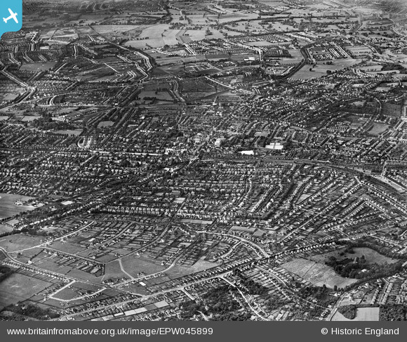
EPW045899 ENGLAND (1934). Belmont village and Sutton town, Belmont, from the south-east, 1934
© Copyright OpenStreetMap contributors and licensed by the OpenStreetMap Foundation. 2026. Cartography is licensed as CC BY-SA.
Nearby Images (10)
Details
| Title | [EPW045899] Belmont village and Sutton town, Belmont, from the south-east, 1934 |
| Reference | EPW045899 |
| Date | August-1934 |
| Link | |
| Place name | BELMONT |
| Parish | |
| District | |
| Country | ENGLAND |
| Easting / Northing | 526615, 162956 |
| Longitude / Latitude | -0.18159015270929, 51.35105600259 |
| National Grid Reference | TQ266630 |
Pins

Falcon |
Saturday 21st of December 2013 10:07:56 AM | |

Falcon |
Saturday 21st of December 2013 10:07:25 AM | |

christhewino |
Saturday 6th of July 2013 10:59:51 PM | |

christhewino |
Saturday 6th of July 2013 10:58:12 PM | |

christhewino |
Saturday 6th of July 2013 10:57:40 PM | |

christhewino |
Saturday 6th of July 2013 10:56:41 PM | |

christhewino |
Saturday 6th of July 2013 10:55:42 PM | |

christhewino |
Saturday 6th of July 2013 10:55:13 PM | |

christhewino |
Saturday 6th of July 2013 10:54:47 PM | |

christhewino |
Saturday 6th of July 2013 10:54:05 PM | |

christhewino |
Tuesday 2nd of July 2013 11:14:49 PM | |

christhewino |
Tuesday 2nd of July 2013 11:13:41 PM | |

christhewino |
Tuesday 2nd of July 2013 11:12:18 PM | |

christhewino |
Tuesday 2nd of July 2013 11:09:14 PM | |

christhewino |
Tuesday 2nd of July 2013 11:08:25 PM | |

christhewino |
Tuesday 2nd of July 2013 11:07:49 PM | |

christhewino |
Tuesday 2nd of July 2013 11:07:22 PM |


![[EPW045899] Belmont village and Sutton town, Belmont, from the south-east, 1934](http://britainfromabove.org.uk/sites/all/libraries/aerofilms-images/public/100x100/EPW/045/EPW045899.jpg)
![[EAW037202] Event in progress at 48 The Gallop, Sutton, 1951. This image has been produced from a print marked by Aerofilms Ltd for photo editing.](http://britainfromabove.org.uk/sites/all/libraries/aerofilms-images/public/100x100/EAW/037/EAW037202.jpg)
![[EPW045900] Belmont village and Sutton town, Belmont, from the south-east, 1934](http://britainfromabove.org.uk/sites/all/libraries/aerofilms-images/public/100x100/EPW/045/EPW045900.jpg)
![[EAW037196] Event in progress at 48 The Gallop, Sutton, 1951. This image has been produced from a print marked by Aerofilms Ltd for photo editing.](http://britainfromabove.org.uk/sites/all/libraries/aerofilms-images/public/100x100/EAW/037/EAW037196.jpg)
![[EAW037201] Event in progress at 48 The Gallop, Sutton, 1951. This image has been produced from a print marked by Aerofilms Ltd for photo editing.](http://britainfromabove.org.uk/sites/all/libraries/aerofilms-images/public/100x100/EAW/037/EAW037201.jpg)
![[EAW037195] Event in progress at 48 The Gallop, Sutton, 1951. This image has been produced from a print marked by Aerofilms Ltd for photo editing.](http://britainfromabove.org.uk/sites/all/libraries/aerofilms-images/public/100x100/EAW/037/EAW037195.jpg)
![[EAW037197] Event in progress at 48 The Gallop, Sutton, 1951. This image has been produced from a print marked by Aerofilms Ltd for photo editing.](http://britainfromabove.org.uk/sites/all/libraries/aerofilms-images/public/100x100/EAW/037/EAW037197.jpg)
![[EAW037198] Event in progress at 48 The Gallop, Sutton, 1951. This image has been produced from a print marked by Aerofilms Ltd for photo editing.](http://britainfromabove.org.uk/sites/all/libraries/aerofilms-images/public/100x100/EAW/037/EAW037198.jpg)
![[EAW037199] The Gallop, Sutton, 1951. This image has been produced from a print marked by Aerofilms Ltd for photo editing.](http://britainfromabove.org.uk/sites/all/libraries/aerofilms-images/public/100x100/EAW/037/EAW037199.jpg)
![[EAW037200] Event in progress at 48 The Gallop, Sutton, 1951. This image has been produced from a print marked by Aerofilms Ltd for photo editing.](http://britainfromabove.org.uk/sites/all/libraries/aerofilms-images/public/100x100/EAW/037/EAW037200.jpg)