
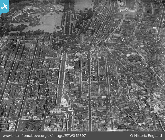
EPW045397 ENGLAND (1934). Portland Place and environs, Marylebone, 1934
© Copyright OpenStreetMap contributors and licensed by the OpenStreetMap Foundation. 2026. Cartography is licensed as CC BY-SA.
Nearby Images (9)
EPW045397

EAW010071

EPW016618

EPW015725

EPW016615

EPW016617

EPW015728

EPW015729

EPW060756

Details
| Title | [EPW045397] Portland Place and environs, Marylebone, 1934 |
| Reference | EPW045397 |
| Date | July-1934 |
| Link | |
| Place name | MARYLEBONE |
| Parish | |
| District | |
| Country | ENGLAND |
| Easting / Northing | 528864, 181930 |
| Longitude / Latitude | -0.14240212100664, 51.521086620981 |
| National Grid Reference | TQ289819 |
Pins

Chaz |
Wednesday 28th of January 2026 05:12:06 PM | |
|
AnthonyN8 |
Tuesday 26th of April 2022 10:18:33 AM | |
|
H.J.Hill |
Wednesday 24th of February 2016 08:25:55 PM | |
|
BenW |
Saturday 30th of August 2014 12:25:43 PM | |

Class31 |
Saturday 14th of June 2014 09:22:07 PM | |
|
Class31 |
Saturday 14th of June 2014 09:21:16 PM | |

Alan McFaden |
Wednesday 31st of July 2013 09:38:59 AM | |
|
Alan McFaden |
Wednesday 31st of July 2013 09:37:00 AM | |
|
Alan McFaden |
Wednesday 31st of July 2013 09:35:43 AM | |
|
FermePark |
Tuesday 21st of May 2013 02:53:11 AM | |
|
FermePark |
Tuesday 21st of May 2013 02:50:20 AM | |
|
FermePark |
Tuesday 21st of May 2013 02:49:20 AM |


User Comment Contributions

Broadcasting House, London |

JMB |
Tuesday 24th of December 2013 07:34:37 PM |