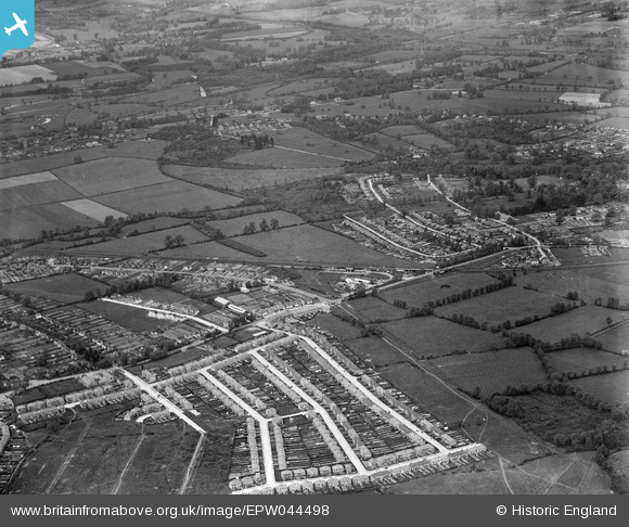
EPW044498 ENGLAND (1934). The London Passenger Transport Board Metropolitan Line, Long Lane and environs, Uxbridge, 1934
© Copyright OpenStreetMap contributors and licensed by the OpenStreetMap Foundation. 2025. Cartography is licensed as CC BY-SA.
Nearby Images (5)
Details
| Title | [EPW044498] The London Passenger Transport Board Metropolitan Line, Long Lane and environs, Uxbridge, 1934 |
| Reference | EPW044498 |
| Date | May-1934 |
| Link | |
| Place name | UXBRIDGE |
| Parish | |
| District | |
| Country | ENGLAND |
| Easting / Northing | 507363, 185023 |
| Longitude / Latitude | -0.45126543246571, 51.55338762516 |
| National Grid Reference | TQ074850 |
Pins

Traceyh |
Friday 26th of May 2023 09:54:30 PM | |

brian |
Monday 27th of January 2014 08:57:18 PM | |

brian |
Monday 27th of January 2014 08:55:56 PM | |

brian |
Monday 27th of January 2014 08:54:26 PM | |

brian |
Monday 27th of January 2014 08:52:09 PM | |

brian |
Monday 27th of January 2014 08:50:23 PM | |

brian |
Monday 27th of January 2014 08:47:43 PM | |

brian |
Monday 27th of January 2014 08:45:53 PM |


![[EPW044498] The London Passenger Transport Board Metropolitan Line, Long Lane and environs, Uxbridge, 1934](http://britainfromabove.org.uk/sites/all/libraries/aerofilms-images/public/100x100/EPW/044/EPW044498.jpg)
![[EPW044198] The LPTB Metropolitan Line, Hercies Road and environs, Uxbridge, 1934](http://britainfromabove.org.uk/sites/all/libraries/aerofilms-images/public/100x100/EPW/044/EPW044198.jpg)
![[EPW044512] The London Passenger Transport Board Metropolitan Line, Hercies Road and environs, Uxbridge, 1934](http://britainfromabove.org.uk/sites/all/libraries/aerofilms-images/public/100x100/EPW/044/EPW044512.jpg)
![[EPW044516] The London Passenger Transport Board Metropolitan Line, Long Lane and environs, Uxbridge, 1934](http://britainfromabove.org.uk/sites/all/libraries/aerofilms-images/public/100x100/EPW/044/EPW044516.jpg)
![[EPW044199] Hillingdon Station on the LPTB Metropolitan Line, Long Lane and environs, Uxbridge, 1934](http://britainfromabove.org.uk/sites/all/libraries/aerofilms-images/public/100x100/EPW/044/EPW044199.jpg)