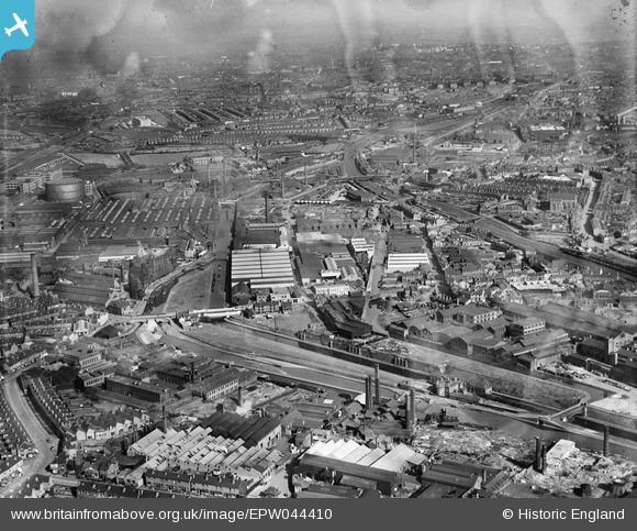
EPW044410 ENGLAND (1934). The Kingston Metal Works and adjacent industrial works, Smethwick, from the north-west, 1934
© Copyright OpenStreetMap contributors and licensed by the OpenStreetMap Foundation. 2026. Cartography is licensed as CC BY-SA.
Nearby Images (18)
EPW044410

EAW017731

EAW017734

EPW044408

EAW017730

EAW017736

EPW044411

EAW017732

EAW017735

EAW017737

EAW017733

EPW044407

EPW044409

EAW017738

EAW014399

EPW053085

EPW053084

EAW001203

Details
| Title | [EPW044410] The Kingston Metal Works and adjacent industrial works, Smethwick, from the north-west, 1934 |
| Reference | EPW044410 |
| Date | May-1934 |
| Link | |
| Place name | SMETHWICK |
| Parish | |
| District | |
| Country | ENGLAND |
| Easting / Northing | 402607, 288994 |
| Longitude / Latitude | -1.9615933575549, 52.498477163703 |
| National Grid Reference | SP026890 |
Pins

Bart |
Sunday 12th of September 2021 11:27:15 AM | |

Class31 |
Thursday 27th of August 2015 08:38:37 PM | |
|
Class31 |
Thursday 27th of August 2015 08:38:03 PM | |
 |
Class31 |
Thursday 27th of August 2015 08:36:44 PM |

bescotbeast |
Tuesday 4th of March 2014 12:24:55 AM | |
I think it's actually Soho Station that was here, Rolfe Street is off to the right of this image. |
Phil Wild |
Thursday 14th of April 2016 11:43:14 AM |
|
bescotbeast |
Tuesday 4th of March 2014 12:18:17 AM | |
|
bescotbeast |
Tuesday 4th of March 2014 12:08:52 AM | |
|
artscotak2 |
Saturday 24th of August 2013 03:06:04 PM | |
|
Martin |
Monday 6th of May 2013 04:26:46 PM | |
|
Martin |
Monday 6th of May 2013 04:26:20 PM | |
also called Indexing Station, demolished during world war 2 |
Martin |
Monday 3rd of March 2014 10:29:23 PM |