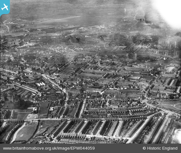
EPW044059 ENGLAND (1934). The city including several of the Singer Motor Car Works, Coventry, 1934. This image has been affected by flare.
© Copyright OpenStreetMap contributors and licensed by the OpenStreetMap Foundation. 2026. Cartography is licensed as CC BY-SA.
Nearby Images (30)
Details
| Title | [EPW044059] The city including several of the Singer Motor Car Works, Coventry, 1934. This image has been affected by flare. |
| Reference | EPW044059 |
| Date | April-1934 |
| Link | |
| Place name | COVENTRY |
| Parish | |
| District | |
| Country | ENGLAND |
| Easting / Northing | 434198, 279375 |
| Longitude / Latitude | -1.4971873766608, 52.410929425893 |
| National Grid Reference | SP342794 |
Pins
Be the first to add a comment to this image!


![[EPW044059] The city including several of the Singer Motor Car Works, Coventry, 1934. This image has been affected by flare.](http://britainfromabove.org.uk/sites/all/libraries/aerofilms-images/public/100x100/EPW/044/EPW044059.jpg)
![[EPW044058] The city including several of the Singer Motor Car Works, Coventry, 1934. This image has been affected by flare.](http://britainfromabove.org.uk/sites/all/libraries/aerofilms-images/public/100x100/EPW/044/EPW044058.jpg)
![[EAW041370] Singer Motors Ltd Works off Canterbury Street and environs, Coventry, 1951. This image has been produced from a damaged negative.](http://britainfromabove.org.uk/sites/all/libraries/aerofilms-images/public/100x100/EAW/041/EAW041370.jpg)
![[EAW041374] Singer Motors Ltd Works off Canterbury Street and Raglan Street and environs, Coventry, 1951. This image was marked by Aerofilms Ltd for photo editing.](http://britainfromabove.org.uk/sites/all/libraries/aerofilms-images/public/100x100/EAW/041/EAW041374.jpg)
![[EPW044057] The city including several of the Singer Motor Car Works, Coventry, 1934. This image has been produced from a damaged negative.](http://britainfromabove.org.uk/sites/all/libraries/aerofilms-images/public/100x100/EPW/044/EPW044057.jpg)
![[EAW041362] Singer Motors Ltd Works on Canterbury Street, Coventry, 1951. This image has been produced from a print marked by Aerofilms Ltd for photo editing.](http://britainfromabove.org.uk/sites/all/libraries/aerofilms-images/public/100x100/EAW/041/EAW041362.jpg)
![[EAW041366] Singer Motors Ltd Works on Canterbury Street, Coventry, 1951. This image has been produced from a print marked by Aerofilms Ltd for photo editing.](http://britainfromabove.org.uk/sites/all/libraries/aerofilms-images/public/100x100/EAW/041/EAW041366.jpg)
![[EAW041371] Singer Motors Ltd Works off Canterbury Street and environs, Coventry, 1951. This image has been produced from a damaged negative.](http://britainfromabove.org.uk/sites/all/libraries/aerofilms-images/public/100x100/EAW/041/EAW041371.jpg)
![[EPW044037] The Singer Motor Car Works, St Peter's Church and environs, Coventry, 1934](http://britainfromabove.org.uk/sites/all/libraries/aerofilms-images/public/100x100/EPW/044/EPW044037.jpg)
![[EAW041373] Singer Motors Ltd Works off Canterbury Street and the city, Coventry, 1951. This image has been produced from a damaged negative.](http://britainfromabove.org.uk/sites/all/libraries/aerofilms-images/public/100x100/EAW/041/EAW041373.jpg)
![[EAW041369] Singer Motors Ltd Works off Canterbury Street and Raglan Street and environs, Coventry, 1951. This image was marked by Aerofilms Ltd for photo editing.](http://britainfromabove.org.uk/sites/all/libraries/aerofilms-images/public/100x100/EAW/041/EAW041369.jpg)
![[EPW044036] The Singer Motor Car Works, St Peter's Church and environs, Coventry, 1934. This image has been produced from a damaged negative.](http://britainfromabove.org.uk/sites/all/libraries/aerofilms-images/public/100x100/EPW/044/EPW044036.jpg)
![[EAW041360] Singer Motors Ltd Works on Canterbury Street, Coventry, 1951. This image has been produced from a print marked by Aerofilms Ltd for photo editing.](http://britainfromabove.org.uk/sites/all/libraries/aerofilms-images/public/100x100/EAW/041/EAW041360.jpg)
![[EPW044035] The Singer Motor Car Works, St Peter's Church and environs, Coventry, 1934](http://britainfromabove.org.uk/sites/all/libraries/aerofilms-images/public/100x100/EPW/044/EPW044035.jpg)
![[EAW041372] Singer Motors Ltd Works off Canterbury Street and environs, Coventry, 1951. This image has been produced from a damaged negative.](http://britainfromabove.org.uk/sites/all/libraries/aerofilms-images/public/100x100/EAW/041/EAW041372.jpg)
![[EAW041358] Singer Motors Ltd Works on Canterbury Street, Coventry, 1951. This image has been produced from a print marked by Aerofilms Ltd for photo editing.](http://britainfromabove.org.uk/sites/all/libraries/aerofilms-images/public/100x100/EAW/041/EAW041358.jpg)
![[EAW041361] Singer Motors Ltd Works on Canterbury Street, Coventry, 1951. This image has been produced from a print marked by Aerofilms Ltd for photo editing.](http://britainfromabove.org.uk/sites/all/libraries/aerofilms-images/public/100x100/EAW/041/EAW041361.jpg)
![[EAW041356] Raglan Street and Singer Motors Ltd Raglan Works, Coventry, 1951. This image has been produced from a print marked by Aerofilms Ltd for photo editing.](http://britainfromabove.org.uk/sites/all/libraries/aerofilms-images/public/100x100/EAW/041/EAW041356.jpg)
![[EAW041363] Singer Motors Ltd Works on Canterbury Street, Coventry, 1951. This image has been produced from a print marked by Aerofilms Ltd for photo editing.](http://britainfromabove.org.uk/sites/all/libraries/aerofilms-images/public/100x100/EAW/041/EAW041363.jpg)
![[EPW044040] The Singer Raglan Motor Car Works, the British Thomson-Houston Co Works and the city centre, Coventry, 1934](http://britainfromabove.org.uk/sites/all/libraries/aerofilms-images/public/100x100/EPW/044/EPW044040.jpg)
![[EAW041349] Singer Motors Ltd Raglan Works, Coventry, 1951. This image has been produced from a print marked by Aerofilms Ltd for photo editing.](http://britainfromabove.org.uk/sites/all/libraries/aerofilms-images/public/100x100/EAW/041/EAW041349.jpg)
![[EPW044060] The city including several of the Singer Motor Car Works, Coventry, 1934](http://britainfromabove.org.uk/sites/all/libraries/aerofilms-images/public/100x100/EPW/044/EPW044060.jpg)
![[EPW044039] The Singer Raglan Motor Car Works, the British Thomson-Houston Co Works and environs, Coventry, 1934](http://britainfromabove.org.uk/sites/all/libraries/aerofilms-images/public/100x100/EPW/044/EPW044039.jpg)
![[EAW041354] Singer Motors Ltd Raglan Works, Coventry, 1951. This image has been produced from a print marked by Aerofilms Ltd for photo editing.](http://britainfromabove.org.uk/sites/all/libraries/aerofilms-images/public/100x100/EAW/041/EAW041354.jpg)
![[EPW044034] The Singer Motor Car Works, St Peter's Church and environs, Coventry, 1934. This image has been produced from a damaged negative.](http://britainfromabove.org.uk/sites/all/libraries/aerofilms-images/public/100x100/EPW/044/EPW044034.jpg)
![[EPW044038] The Singer Raglan Motor Car Works, the British Thomson-Houston Co Works and environs, Coventry, 1934](http://britainfromabove.org.uk/sites/all/libraries/aerofilms-images/public/100x100/EPW/044/EPW044038.jpg)
![[EAW041353] Singer Motors Ltd Raglan Works, Coventry, 1951. This image has been produced from a print marked by Aerofilms Ltd for photo editing.](http://britainfromabove.org.uk/sites/all/libraries/aerofilms-images/public/100x100/EAW/041/EAW041353.jpg)
![[EPW061096] The Singer Motor Car Works, Coventry City Football Ground at Highfield Road and the eastern part of the city, Coventry, from the west, 1939](http://britainfromabove.org.uk/sites/all/libraries/aerofilms-images/public/100x100/EPW/061/EPW061096.jpg)
![[EAW041355] Singer Motors Ltd Raglan Works, Coventry, 1951. This image has been produced from a print marked by Aerofilms Ltd for photo editing.](http://britainfromabove.org.uk/sites/all/libraries/aerofilms-images/public/100x100/EAW/041/EAW041355.jpg)
![[EAW041346] Singer Motors Ltd Works off Payne's Lane, Coventry, 1951. This image has been produced from a print marked by Aerofilms Ltd for photo editing.](http://britainfromabove.org.uk/sites/all/libraries/aerofilms-images/public/100x100/EAW/041/EAW041346.jpg)