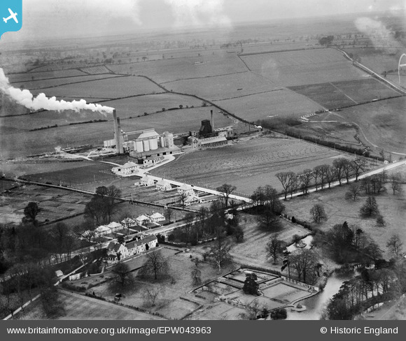
EPW043963 ENGLAND (1934). The Ketton Portland Cement Co Works and surrounding countryside, Ketton, from the south, 1934
© Copyright OpenStreetMap contributors and licensed by the OpenStreetMap Foundation. 2026. Cartography is licensed as CC BY-SA.
Details
| Title | [EPW043963] The Ketton Portland Cement Co Works and surrounding countryside, Ketton, from the south, 1934 |
| Reference | EPW043963 |
| Date | April-1934 |
| Link | |
| Place name | KETTON |
| Parish | KETTON |
| District | |
| Country | ENGLAND |
| Easting / Northing | 498512, 305092 |
| Longitude / Latitude | -0.54417877285776, 52.634274494466 |
| National Grid Reference | SK985051 |
Pins

Class31 |
Monday 14th of April 2014 08:35:16 AM | |

Dylan Moore |
Tuesday 7th of May 2013 03:18:36 PM | |

Dylan Moore |
Tuesday 7th of May 2013 03:18:17 PM | |

Dylan Moore |
Tuesday 7th of May 2013 03:17:31 PM | |

Dylan Moore |
Tuesday 7th of May 2013 03:17:00 PM | |

Dylan Moore |
Tuesday 7th of May 2013 03:16:43 PM | |

Dylan Moore |
Tuesday 7th of May 2013 03:15:55 PM | |

Dylan Moore |
Monday 6th of May 2013 10:44:47 AM | |

Dylan Moore |
Friday 3rd of May 2013 08:56:54 PM | |

Dylan Moore |
Friday 3rd of May 2013 08:56:27 PM | |

Dylan Moore |
Friday 3rd of May 2013 08:55:25 PM | |

Dylan Moore |
Friday 3rd of May 2013 08:55:00 PM | |

Dylan Moore |
Friday 3rd of May 2013 08:54:34 PM |
User Comment Contributions
Looking along Ketco Avenue from the junction with Stamford Road 12/04/2014 |

Class31 |
Monday 14th of April 2014 08:37:54 AM |
Looking north from the junction of Ketco Avenue and Stamford Road A6121 12/04/2014 |

Class31 |
Monday 14th of April 2014 08:33:18 AM |
Kiln 2 was started on 21/10/1933. Along with this, a number of other additions have appeared since the pictures taken in 1929, after the plant started up. |

Dylan Moore |
Friday 3rd of May 2013 09:00:02 PM |


![[EPW043963] The Ketton Portland Cement Co Works and surrounding countryside, Ketton, from the south, 1934](http://britainfromabove.org.uk/sites/all/libraries/aerofilms-images/public/100x100/EPW/043/EPW043963.jpg)
![[EPW043958] The Ketton Portland Cement Co Works and surrounding countryside, Ketton, from the south, 1934](http://britainfromabove.org.uk/sites/all/libraries/aerofilms-images/public/100x100/EPW/043/EPW043958.jpg)