
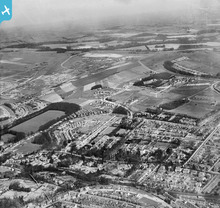
EPW043907 ENGLAND (1934). Withdean Park, housing development around Withdean Crescent and environs, Withdean, from the south-west, 1934

© Copyright OpenStreetMap contributors and licensed by the OpenStreetMap Foundation. 2026. Cartography is licensed as CC BY-SA.
Nearby Images (2)
EPW043907

EPW043909

Details
| Title | [EPW043907] Withdean Park, housing development around Withdean Crescent and environs, Withdean, from the south-west, 1934 |
| Reference | EPW043907 |
| Date | March-1934 |
| Link | |
| Place name | WITHDEAN |
| Parish | |
| District | |
| Country | ENGLAND |
| Easting / Northing | 530322, 107061 |
| Longitude / Latitude | -0.14856378075074, 50.847812650923 |
| National Grid Reference | TQ303071 |
Pins

Josh Springer |
Wednesday 27th of November 2013 06:42:28 PM |
User Comment Contributions
Withdean/London Road 1934 |
classicforever |
Sunday 7th of July 2013 11:06:53 AM |