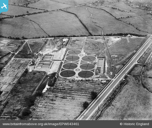
EPW043461 ENGLAND (1933). The Sewage Disposal Works, Cannock, 1933
© Copyright OpenStreetMap contributors and licensed by the OpenStreetMap Foundation. 2026. Cartography is licensed as CC BY-SA.
Nearby Images (9)
Details
| Title | [EPW043461] The Sewage Disposal Works, Cannock, 1933 |
| Reference | EPW043461 |
| Date | October-1933 |
| Link | |
| Place name | CANNOCK |
| Parish | |
| District | |
| Country | ENGLAND |
| Easting / Northing | 397469, 308920 |
| Longitude / Latitude | -2.0374393607337, 52.677629024225 |
| National Grid Reference | SJ975089 |
Pins

GeoffR |
Wednesday 9th of November 2016 08:22:42 PM |


![[EPW043461] The Sewage Disposal Works, Cannock, 1933](http://britainfromabove.org.uk/sites/all/libraries/aerofilms-images/public/100x100/EPW/043/EPW043461.jpg)
![[EPW043459] The Sewage Disposal Works, Cannock, 1933](http://britainfromabove.org.uk/sites/all/libraries/aerofilms-images/public/100x100/EPW/043/EPW043459.jpg)
![[EPW043463] The Sewage Disposal Works, Cannock, 1933](http://britainfromabove.org.uk/sites/all/libraries/aerofilms-images/public/100x100/EPW/043/EPW043463.jpg)
![[EPW043457] The Sewage Disposal Works, Cannock, 1933](http://britainfromabove.org.uk/sites/all/libraries/aerofilms-images/public/100x100/EPW/043/EPW043457.jpg)
![[EPW043462] The Sewage Disposal Works, Cannock, 1933](http://britainfromabove.org.uk/sites/all/libraries/aerofilms-images/public/100x100/EPW/043/EPW043462.jpg)
![[EPW043460] The Sewage Disposal Works, Cannock, 1933](http://britainfromabove.org.uk/sites/all/libraries/aerofilms-images/public/100x100/EPW/043/EPW043460.jpg)
![[EPW043464] The Sewage Disposal Works, the Longhouse Brick and Tile Works and surrounding countryside, Cannock, 1933](http://britainfromabove.org.uk/sites/all/libraries/aerofilms-images/public/100x100/EPW/043/EPW043464.jpg)
![[EPW043465] The Sewage Disposal Works, the Longhouse Brick and Tile Works and surrounding countryside, Cannock, 1933](http://britainfromabove.org.uk/sites/all/libraries/aerofilms-images/public/100x100/EPW/043/EPW043465.jpg)
![[EPW043458] The Sewage Disposal Works, Cannock, 1933](http://britainfromabove.org.uk/sites/all/libraries/aerofilms-images/public/100x100/EPW/043/EPW043458.jpg)