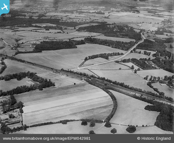
EPW042981 ENGLAND (1933). A recently constructed section of the A412 (North Orbital Road) beside the site of Denham Studios, Denham Green, from the south-east, 1933
© Copyright OpenStreetMap contributors and licensed by the OpenStreetMap Foundation. 2026. Cartography is licensed as CC BY-SA.
Details
| Title | [EPW042981] A recently constructed section of the A412 (North Orbital Road) beside the site of Denham Studios, Denham Green, from the south-east, 1933 |
| Reference | EPW042981 |
| Date | September-1933 |
| Link | |
| Place name | DENHAM GREEN |
| Parish | DENHAM |
| District | |
| Country | ENGLAND |
| Easting / Northing | 504424, 187401 |
| Longitude / Latitude | -0.49293847979337, 51.575315947609 |
| National Grid Reference | TQ044874 |
Pins

andy |
Monday 8th of July 2013 07:35:34 PM | |

moses72 |
Thursday 27th of June 2013 12:27:49 PM | |
No, this is not in fact a railway line. Denham West Junction for Uxbridge was further to the east than Denham Station. If this was the railway line here, it would still have track in place at this date (there is none), and it can clearly be seen that the 'line' does not even run into the station! The Grand Junction Canal runs under the main line just to the west of the actual junction, and it's not in this photo, it's the road mentioned seen passing under that bridge. That curved line of trees is in fact just an avenue of trees lining a lane - to nowhere, so it seems. (Check it out on www.old-maps.co.uk and I think you'll have to agree.) |

Isleworth1961 |
Tuesday 9th of July 2013 11:29:14 PM |
Isleworth 1961 - you are of course quite correct - this curve of trees is NOT the Uxbridge line junction! Sorry for my basic error! |

moses72 |
Friday 20th of September 2013 12:13:01 PM |
Check your Google Earth, you are the wrong side of the canal. This is a curved avenue on the Buckinhamshire Golf Club. I can see what you thought. |

Mike |
Tuesday 17th of June 2014 12:55:42 PM |
Curiously, this curved avenue does not seem to appear on any old maps. It still exists and runs though what is now the Buckinghamshire Golf Course. One wonders if it was not an ancient feature but was a convenient private thoroughfare built to connect Denham railway station with Denham Court Mansion. |

The Laird |
Sunday 24th of February 2019 09:38:48 PM |

moses72 |
Thursday 27th of June 2013 12:19:20 PM | |

moses72 |
Thursday 27th of June 2013 12:18:41 PM | |

moses72 |
Thursday 27th of June 2013 12:17:01 PM | |

Croxley history |
Tuesday 14th of May 2013 09:53:41 PM | |

Croxley history |
Tuesday 14th of May 2013 09:50:28 PM | |

Croxley history |
Tuesday 14th of May 2013 09:48:08 PM |


![[EPW042981] A recently constructed section of the A412 (North Orbital Road) beside the site of Denham Studios, Denham Green, from the south-east, 1933](http://britainfromabove.org.uk/sites/all/libraries/aerofilms-images/public/100x100/EPW/042/EPW042981.jpg)
![[EPW042982] A recently constructed section of the A412 (North Orbital Road) beside the site of Denham Studios, Denham Green, from the south-east, 1933](http://britainfromabove.org.uk/sites/all/libraries/aerofilms-images/public/100x100/EPW/042/EPW042982.jpg)
![[EPW042983] A recently constructed section of the A412 (North Orbital Road) beside the site of Denham Studios, Denham Green, from the south-east, 1933](http://britainfromabove.org.uk/sites/all/libraries/aerofilms-images/public/100x100/EPW/042/EPW042983.jpg)