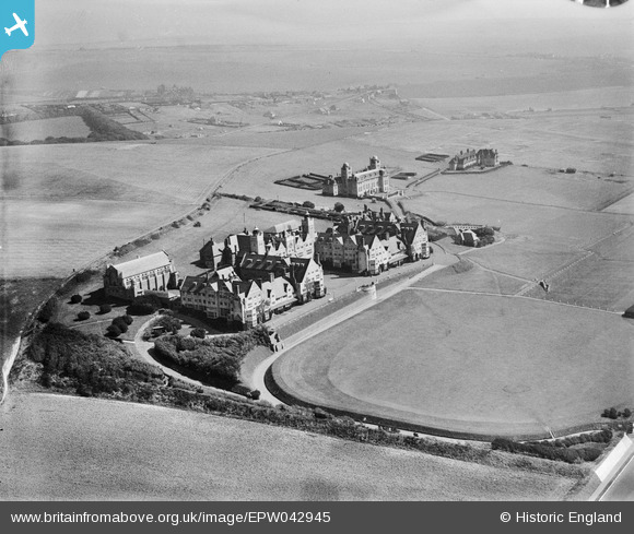
EPW042945 ENGLAND (1933). Roedean School, Roedean, 1933
© Copyright OpenStreetMap contributors and licensed by the OpenStreetMap Foundation. 2024. Cartography is licensed as CC BY-SA.
Nearby Images (9)
Details
| Title | [EPW042945] Roedean School, Roedean, 1933 |
| Reference | EPW042945 |
| Date | August-1933 |
| Link | |
| Place name | ROEDEAN |
| Parish | |
| District | |
| Country | ENGLAND |
| Easting / Northing | 535034, 103165 |
| Longitude / Latitude | -0.083096795744129, 50.811712570195 |
| National Grid Reference | TQ350032 |
Pins
 Alan McFaden |
Sunday 17th of November 2013 08:43:09 PM |


![[EPW042945] Roedean School, Roedean, 1933](http://britainfromabove.org.uk/sites/all/libraries/aerofilms-images/public/100x100/EPW/042/EPW042945.jpg)
![[EPW041363] Roedean School, Roedean, 1933](http://britainfromabove.org.uk/sites/all/libraries/aerofilms-images/public/100x100/EPW/041/EPW041363.jpg)
![[EPW000691] Roedean School, Roedean, 1920](http://britainfromabove.org.uk/sites/all/libraries/aerofilms-images/public/100x100/EPW/000/EPW000691.jpg)
![[EPW054182] Roedean Girls' School, Roedean, 1937](http://britainfromabove.org.uk/sites/all/libraries/aerofilms-images/public/100x100/EPW/054/EPW054182.jpg)
![[EPW042943] Roedean School, Roedean, 1933](http://britainfromabove.org.uk/sites/all/libraries/aerofilms-images/public/100x100/EPW/042/EPW042943.jpg)
![[EPW042944] Roedean School, Roedean, 1933](http://britainfromabove.org.uk/sites/all/libraries/aerofilms-images/public/100x100/EPW/042/EPW042944.jpg)
![[EPW017747] Roedean School and playing fields, Roedean, from the south-west, 1927](http://britainfromabove.org.uk/sites/all/libraries/aerofilms-images/public/100x100/EPW/017/EPW017747.jpg)
![[EPW017746] Roedean School and playing field, Roedean, from the south-west, 1927](http://britainfromabove.org.uk/sites/all/libraries/aerofilms-images/public/100x100/EPW/017/EPW017746.jpg)
![[EPW054059] Roedean School, Roedean, 1937](http://britainfromabove.org.uk/sites/all/libraries/aerofilms-images/public/100x100/EPW/054/EPW054059.jpg)
