
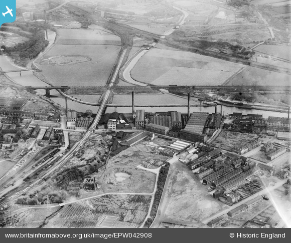
EPW042908 ENGLAND (1933). Mills off Huddersfield Road and environs, Ravensthorpe, 1933
© Copyright OpenStreetMap contributors and licensed by the OpenStreetMap Foundation. 2026. Cartography is licensed as CC BY-SA.
Nearby Images (14)
EPW042908
 0°
0m
0°
0m
EPW048721
 108°
6m
108°
6m
EPW042907
 148°
13m
148°
13m
EPW042905
 34°
25m
34°
25m
EPW042904
 22°
26m
22°
26m
EPW048719
 309°
55m
309°
55m
EPW048722
 322°
64m
322°
64m
EPW042906
 319°
69m
319°
69m
EPW048718
 98°
74m
98°
74m
EPW048716
 271°
86m
271°
86m
EPW048720
 316°
91m
316°
91m
EPW048715
 347°
110m
347°
110m
EPW048717
 331°
159m
331°
159m
EPW048714
 309°
172m
309°
172m
Details
| Title | [EPW042908] Mills off Huddersfield Road and environs, Ravensthorpe, 1933 |
| Reference | EPW042908 |
| Date | August-1933 |
| Link | |
| Place name | RAVENSTHORPE |
| Parish | |
| District | |
| Country | ENGLAND |
| Easting / Northing | 423097, 420455 |
| Longitude / Latitude | -1.6502840040529, 53.679818152149 |
| National Grid Reference | SE231205 |
Pins
 Lower Ravensthorpe Station (Up line) also once known as the Thornhill and Ravensthorpe Station on the Lancashire and Yorkshire Railway. Closed circa 1953 Lower Ravensthorpe Station (Up line) also once known as the Thornhill and Ravensthorpe Station on the Lancashire and Yorkshire Railway. Closed circa 1953 |

Richard |
Friday 24th of July 2026 10:27:17 AM |
| signal box l.y main line jct for ravensthorpe branch |
HOLMES |
Tuesday 22nd of September 2015 10:52:40 AM |