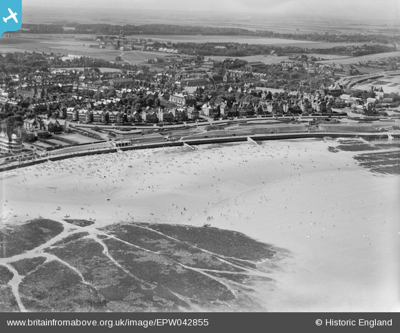
EPW042855 ENGLAND (1933). St Mildred's Bay and environs, Westgate-on-Sea, from the north-east, 1933
© Copyright OpenStreetMap contributors and licensed by the OpenStreetMap Foundation. 2026. Cartography is licensed as CC BY-SA.
Nearby Images (12)
Details
| Title | [EPW042855] St Mildred's Bay and environs, Westgate-on-Sea, from the north-east, 1933 |
| Reference | EPW042855 |
| Date | August-1933 |
| Link | |
| Place name | WESTGATE-ON-SEA |
| Parish | |
| District | |
| Country | ENGLAND |
| Easting / Northing | 632596, 170495 |
| Longitude / Latitude | 1.3432648991578, 51.385258176127 |
| National Grid Reference | TR326705 |
Pins
Be the first to add a comment to this image!


![[EPW042855] St Mildred's Bay and environs, Westgate-on-Sea, from the north-east, 1933](http://britainfromabove.org.uk/sites/all/libraries/aerofilms-images/public/100x100/EPW/042/EPW042855.jpg)
![[EPW035478] St Mildred's Bay and environs, Westgate-on-Sea, 1931](http://britainfromabove.org.uk/sites/all/libraries/aerofilms-images/public/100x100/EPW/035/EPW035478.jpg)
![[EAW015837] St Mildred's Bay and environs, Westgate on Sea, 1948. This image has been produced from a print.](http://britainfromabove.org.uk/sites/all/libraries/aerofilms-images/public/100x100/EAW/015/EAW015837.jpg)
![[EPW009159] The Esplanade and St Mildred's Bay, Westgate-on-Sea, 1923](http://britainfromabove.org.uk/sites/all/libraries/aerofilms-images/public/100x100/EPW/009/EPW009159.jpg)
![[EPW009160] The Esplanade and St Mildred's Bay, Westgate-on-Sea, 1923](http://britainfromabove.org.uk/sites/all/libraries/aerofilms-images/public/100x100/EPW/009/EPW009160.jpg)
![[EPW009156] The Esplanade and St Mildred's Bay, Westgate-on-Sea, 1923](http://britainfromabove.org.uk/sites/all/libraries/aerofilms-images/public/100x100/EPW/009/EPW009156.jpg)
![[EPW009158] The Esplanade and St Mildred's Bay, Westgate-on-Sea, 1923](http://britainfromabove.org.uk/sites/all/libraries/aerofilms-images/public/100x100/EPW/009/EPW009158.jpg)
![[EAW015839] The Gardens, St Mildred's Bay and environs, Westgate on Sea, 1948. This image has been produced from a print.](http://britainfromabove.org.uk/sites/all/libraries/aerofilms-images/public/100x100/EAW/015/EAW015839.jpg)
![[EPW009157] The Esplanade and St Mildred's Bay, Westgate-on-Sea, 1923](http://britainfromabove.org.uk/sites/all/libraries/aerofilms-images/public/100x100/EPW/009/EPW009157.jpg)
![[EPW054077] St Mildred's Bay, St Mildred's Hotel and environs, Westgate-on-Sea, from the north-west, 1937](http://britainfromabove.org.uk/sites/all/libraries/aerofilms-images/public/100x100/EPW/054/EPW054077.jpg)
![[EPW042856] St Mildred's Bay and environs, Westgate-on-Sea, from the north-east, 1933](http://britainfromabove.org.uk/sites/all/libraries/aerofilms-images/public/100x100/EPW/042/EPW042856.jpg)
![[EPW035479] St Mildred's Bay and environs, Westgate-on-Sea, from the north-east, 1931](http://britainfromabove.org.uk/sites/all/libraries/aerofilms-images/public/100x100/EPW/035/EPW035479.jpg)