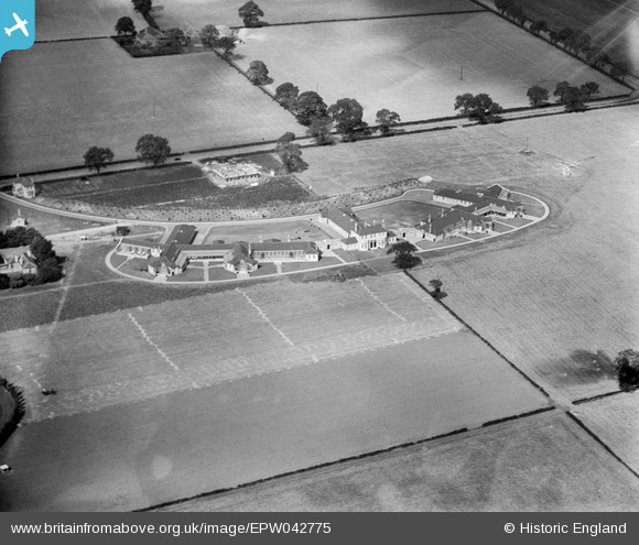
EPW042775 ENGLAND (1933). Bracebridge Heath Hospital, Bracebridge Heath, 1933
© Copyright OpenStreetMap contributors and licensed by the OpenStreetMap Foundation. 2025. Cartography is licensed as CC BY-SA.
Nearby Images (5)
Details
| Title | [EPW042775] Bracebridge Heath Hospital, Bracebridge Heath, 1933 |
| Reference | EPW042775 |
| Date | August-1933 |
| Link | |
| Place name | BRACEBRIDGE HEATH |
| Parish | BRACEBRIDGE HEATH |
| District | |
| Country | ENGLAND |
| Easting / Northing | 498472, 367808 |
| Longitude / Latitude | -0.52574781074375, 53.197935834909 |
| National Grid Reference | SK985678 |
Pins
Be the first to add a comment to this image!


![[EPW042775] Bracebridge Heath Hospital, Bracebridge Heath, 1933](http://britainfromabove.org.uk/sites/all/libraries/aerofilms-images/public/100x100/EPW/042/EPW042775.jpg)
![[EPW042779] Bracebridge Heath Hospital, Bracebridge Heath, 1933](http://britainfromabove.org.uk/sites/all/libraries/aerofilms-images/public/100x100/EPW/042/EPW042779.jpg)
![[EPW042776] Bracebridge Heath Hospital, Bracebridge Heath, 1933](http://britainfromabove.org.uk/sites/all/libraries/aerofilms-images/public/100x100/EPW/042/EPW042776.jpg)
![[EPW042777] Bracebridge Heath Hospital, Bracebridge Heath, 1933](http://britainfromabove.org.uk/sites/all/libraries/aerofilms-images/public/100x100/EPW/042/EPW042777.jpg)
![[EPW042778] Bracebridge Heath Hospital, Bracebridge Heath, 1933](http://britainfromabove.org.uk/sites/all/libraries/aerofilms-images/public/100x100/EPW/042/EPW042778.jpg)