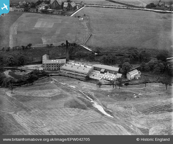
EPW042705 ENGLAND (1933). The Edenwood Cotton Dyeing Mill, Ramsbottom, 1933
© Copyright OpenStreetMap contributors and licensed by the OpenStreetMap Foundation. 2026. Cartography is licensed as CC BY-SA.
Nearby Images (5)
Details
| Title | [EPW042705] The Edenwood Cotton Dyeing Mill, Ramsbottom, 1933 |
| Reference | EPW042705 |
| Date | August-1933 |
| Link | |
| Place name | RAMSBOTTOM |
| Parish | |
| District | |
| Country | ENGLAND |
| Easting / Northing | 379827, 418438 |
| Longitude / Latitude | -2.3053128019115, 53.661808265584 |
| National Grid Reference | SD798184 |
Pins

wadey |
Tuesday 4th of November 2025 09:15:38 PM |


![[EPW042705] The Edenwood Cotton Dyeing Mill, Ramsbottom, 1933](http://britainfromabove.org.uk/sites/all/libraries/aerofilms-images/public/100x100/EPW/042/EPW042705.jpg)
![[EPW042703] The Edenwood Cotton Dyeing Mill, Ramsbottom, 1933](http://britainfromabove.org.uk/sites/all/libraries/aerofilms-images/public/100x100/EPW/042/EPW042703.jpg)
![[EPW042704] The Edenwood Cotton Dyeing Mill, Ramsbottom, 1933. This image has been produced from a damaged negative.](http://britainfromabove.org.uk/sites/all/libraries/aerofilms-images/public/100x100/EPW/042/EPW042704.jpg)
![[EPW042699] The Edenwood Cotton Dyeing Mill, Ramsbottom, 1933](http://britainfromabove.org.uk/sites/all/libraries/aerofilms-images/public/100x100/EPW/042/EPW042699.jpg)
![[EPW042702] The Edenwood Cotton Dyeing Mill, Ramsbottom, 1933](http://britainfromabove.org.uk/sites/all/libraries/aerofilms-images/public/100x100/EPW/042/EPW042702.jpg)