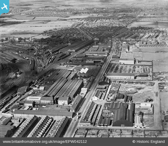
EPW042112 ENGLAND (1933). The C A Parsons and Co Heaton Works, Shields Road and environs, Heaton, 1933
© Copyright OpenStreetMap contributors and licensed by the OpenStreetMap Foundation. 2026. Cartography is licensed as CC BY-SA.
Nearby Images (21)
Details
| Title | [EPW042112] The C A Parsons and Co Heaton Works, Shields Road and environs, Heaton, 1933 |
| Reference | EPW042112 |
| Date | June-1933 |
| Link | |
| Place name | HEATON |
| Parish | |
| District | |
| Country | ENGLAND |
| Easting / Northing | 427855, 565493 |
| Longitude / Latitude | -1.5646900386787, 54.983182408919 |
| National Grid Reference | NZ279655 |
Pins

Caroline |
Friday 23rd of August 2013 02:52:23 PM | |

Caroline |
Friday 23rd of August 2013 02:45:35 PM | |

Caroline |
Friday 23rd of August 2013 02:44:21 PM | |

Caroline |
Friday 23rd of August 2013 02:42:11 PM | |

Caroline |
Friday 23rd of August 2013 02:41:27 PM |


![[EPW042112] The C A Parsons and Co Heaton Works, Shields Road and environs, Heaton, 1933](http://britainfromabove.org.uk/sites/all/libraries/aerofilms-images/public/100x100/EPW/042/EPW042112.jpg)
![[EPW059896] C.A. Parsons and Co Ltd Heaton Works and environs, Newcastle upon Tyne, 1938. This image has been produced from a print.](http://britainfromabove.org.uk/sites/all/libraries/aerofilms-images/public/100x100/EPW/059/EPW059896.jpg)
![[EAW005495] Works off Shields Road including C.A. Parsons and Co Heaton Works, Heaton, 1947](http://britainfromabove.org.uk/sites/all/libraries/aerofilms-images/public/100x100/EAW/005/EAW005495.jpg)
![[EAW005494] C.A. Parsons and Co Heaton Works and Heaton Junction, Heaton, 1947](http://britainfromabove.org.uk/sites/all/libraries/aerofilms-images/public/100x100/EAW/005/EAW005494.jpg)
![[EAW005497] Works off Shields Road including C.A. Parsons and Co Heaton Works, Heaton, 1947](http://britainfromabove.org.uk/sites/all/libraries/aerofilms-images/public/100x100/EAW/005/EAW005497.jpg)
![[EPW042113] The C A Parsons and Co Heaton Works, Shields Road and environs, Heaton, 1933](http://britainfromabove.org.uk/sites/all/libraries/aerofilms-images/public/100x100/EPW/042/EPW042113.jpg)
![[EAW005493] Works off Shields Road including C.A. Parsons and Co Heaton Works, Heaton Junction and environs, Heaton, 1947](http://britainfromabove.org.uk/sites/all/libraries/aerofilms-images/public/100x100/EAW/005/EAW005493.jpg)
![[EAW006058] The C. A. Parsons & Co Heaton Works and environs, Heaton, 1947. This image was marked by Aerofilms Ltd for photo editing.](http://britainfromabove.org.uk/sites/all/libraries/aerofilms-images/public/100x100/EAW/006/EAW006058.jpg)
![[EAW006057] The C. A. Parsons & Co Heaton Works and environs, Heaton, 1947](http://britainfromabove.org.uk/sites/all/libraries/aerofilms-images/public/100x100/EAW/006/EAW006057.jpg)
![[EPW054563] Heaton, Walker and Byker, Newcastle upon Tyne, from the north-east, 1937](http://britainfromabove.org.uk/sites/all/libraries/aerofilms-images/public/100x100/EPW/054/EPW054563.jpg)
![[EAW022484] C.A. Parsons and Co Heaton Heavy Electrical Plant Works and environs, Heaton, 1949. This image has been produced from a print marked by Aerofilms Ltd for photo editing.](http://britainfromabove.org.uk/sites/all/libraries/aerofilms-images/public/100x100/EAW/022/EAW022484.jpg)
![[EPW042114] The C A Parsons and Co Heaton Works, Shields Road and environs, Heaton, 1933](http://britainfromabove.org.uk/sites/all/libraries/aerofilms-images/public/100x100/EPW/042/EPW042114.jpg)
![[EAW006056] The C. A. Parsons & Co Heaton Works and environs, Heaton, 1947. This image was marked by Aerofilms Ltd for photo editing.](http://britainfromabove.org.uk/sites/all/libraries/aerofilms-images/public/100x100/EAW/006/EAW006056.jpg)
![[EAW022482] C.A. Parsons and Co Heaton Heavy Electrical Plant Works and environs, Heaton, 1949. This image has been produced from a print marked by Aerofilms Ltd for photo editing.](http://britainfromabove.org.uk/sites/all/libraries/aerofilms-images/public/100x100/EAW/022/EAW022482.jpg)
![[EAW005496] Works off Shields Road including C.A. Parsons and Co Heaton Works, Heaton, 1947](http://britainfromabove.org.uk/sites/all/libraries/aerofilms-images/public/100x100/EAW/005/EAW005496.jpg)
![[EPW059895] C.A. Parsons and Co Ltd Heaton Works and environs, Newcastle upon Tyne, 1938. This image has been produced from a print.](http://britainfromabove.org.uk/sites/all/libraries/aerofilms-images/public/100x100/EPW/059/EPW059895.jpg)
![[EPW042109] The C A Parsons and Co Heaton Works, Shields Road and environs, Heaton, 1933](http://britainfromabove.org.uk/sites/all/libraries/aerofilms-images/public/100x100/EPW/042/EPW042109.jpg)
![[EAW006059] Shields Road and environs, Heaton, 1947](http://britainfromabove.org.uk/sites/all/libraries/aerofilms-images/public/100x100/EAW/006/EAW006059.jpg)
![[EAW005492] Works off Shields Road including C.A. Parsons and Co Heaton Works, Heaton Junction and environs, Heaton, 1947](http://britainfromabove.org.uk/sites/all/libraries/aerofilms-images/public/100x100/EAW/005/EAW005492.jpg)
![[EPW042110] The C A Parsons and Co Heaton Works, Shields Road and environs, Heaton, 1933](http://britainfromabove.org.uk/sites/all/libraries/aerofilms-images/public/100x100/EPW/042/EPW042110.jpg)
![[EAW022481] C.A. Parsons and Co Heaton Heavy Electrical Plant Works and environs, Heaton, from the south-west, 1949. This image has been produced from a print marked by Aerofilms Ltd for photo editing.](http://britainfromabove.org.uk/sites/all/libraries/aerofilms-images/public/100x100/EAW/022/EAW022481.jpg)