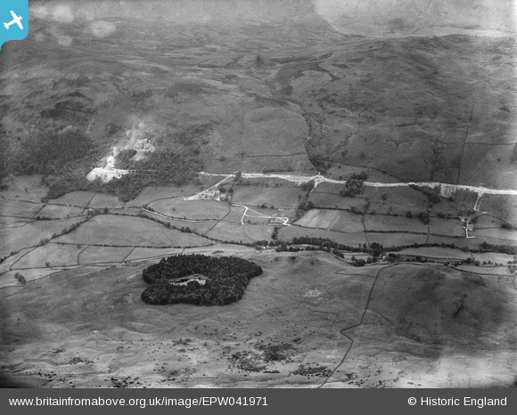
EPW041971 ENGLAND (1933). The Haweswater Aqueduct under construction near Low House, Longsleddale, 1933
© Copyright OpenStreetMap contributors and licensed by the OpenStreetMap Foundation. 2026. Cartography is licensed as CC BY-SA.
Nearby Images (6)
Details
| Title | [EPW041971] The Haweswater Aqueduct under construction near Low House, Longsleddale, 1933 |
| Reference | EPW041971 |
| Date | June-1933 |
| Link | |
| Place name | LONGSLEDDALE |
| Parish | LONGSLEDDALE |
| District | |
| Country | ENGLAND |
| Easting / Northing | 351213, 501203 |
| Longitude / Latitude | -2.7516486222584, 54.40380493111 |
| National Grid Reference | NY512012 |
Pins
Be the first to add a comment to this image!


![[EPW041971] The Haweswater Aqueduct under construction near Low House, Longsleddale, 1933](http://britainfromabove.org.uk/sites/all/libraries/aerofilms-images/public/100x100/EPW/041/EPW041971.jpg)
![[EPW041944] The Haweswater Aqueduct under construction near Low House, Longsleddale, 1933](http://britainfromabove.org.uk/sites/all/libraries/aerofilms-images/public/100x100/EPW/041/EPW041944.jpg)
![[EPW041963] The Haweswater Aqueduct under construction near Low House, Longsleddale, 1933](http://britainfromabove.org.uk/sites/all/libraries/aerofilms-images/public/100x100/EPW/041/EPW041963.jpg)
![[EPW041948] The Haweswater Aqueduct under construction near Low House, Longsleddale, 1933](http://britainfromabove.org.uk/sites/all/libraries/aerofilms-images/public/100x100/EPW/041/EPW041948.jpg)
![[EPW048579] The valley, Longsleddale, from the south-east, 1935](http://britainfromabove.org.uk/sites/all/libraries/aerofilms-images/public/100x100/EPW/048/EPW048579.jpg)
![[EPW041952] The Haweswater Aqueduct under construction near Low House, Longsleddale, 1933](http://britainfromabove.org.uk/sites/all/libraries/aerofilms-images/public/100x100/EPW/041/EPW041952.jpg)