
EPW041893 ENGLAND (1933). All Saints' Church, Slad Road and surrounding countryside, Uplands, 1933,

© Copyright OpenStreetMap contributors and licensed by the OpenStreetMap Foundation. 2026. Cartography is licensed as CC BY-SA.
Nearby Images (2)
EPW041893

EPW041892

Details
| Title | [EPW041893] All Saints' Church, Slad Road and surrounding countryside, Uplands, 1933, |
| Reference | EPW041893 |
| Date | June-1933 |
| Link | |
| Place name | UPLANDS |
| Parish | STROUD |
| District | |
| Country | ENGLAND |
| Easting / Northing | 385676, 205780 |
| Longitude / Latitude | -2.2075174415575, 51.750077328155 |
| National Grid Reference | SO857058 |
Pins
Be the first to add a comment to this image!
User Comment Contributions
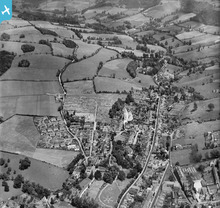
A good view up the Slad valley |

cookie |
Wednesday 12th of February 2014 01:34:23 PM |