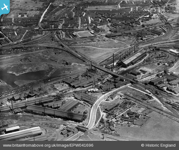
EPW041696 ENGLAND (1933). The Phoenix Special Steel Works and environs, Rotherham, 1933
© Copyright OpenStreetMap contributors and licensed by the OpenStreetMap Foundation. 2026. Cartography is licensed as CC BY-SA.
Nearby Images (23)
Details
| Title | [EPW041696] The Phoenix Special Steel Works and environs, Rotherham, 1933 |
| Reference | EPW041696 |
| Date | June-1933 |
| Link | |
| Place name | ROTHERHAM |
| Parish | |
| District | |
| Country | ENGLAND |
| Easting / Northing | 441775, 391996 |
| Longitude / Latitude | -1.3712947979142, 53.42284520773 |
| National Grid Reference | SK418920 |
Pins
MandM |
Wednesday 12th of November 2014 07:54:57 PM | |
MandM |
Wednesday 12th of November 2014 07:53:57 PM | |
MandM |
Wednesday 12th of November 2014 07:52:53 PM | |
MandM |
Wednesday 12th of November 2014 07:51:58 PM |


![[EPW041696] The Phoenix Special Steel Works and environs, Rotherham, 1933](http://britainfromabove.org.uk/sites/all/libraries/aerofilms-images/public/100x100/EPW/041/EPW041696.jpg)
![[EAW029399] The Steel, Peech and Tozer Phoenix Special Steel Works and environs, Ickles, 1950](http://britainfromabove.org.uk/sites/all/libraries/aerofilms-images/public/100x100/EAW/029/EAW029399.jpg)
![[EAW025970] The Phoenix Special Steel Works, Ickles, 1949. This image has been produced from a print.](http://britainfromabove.org.uk/sites/all/libraries/aerofilms-images/public/100x100/EAW/025/EAW025970.jpg)
![[EPW041699] The Phoenix Special Steel Works, the Rother Iron Works and the town, Rotherham, 1933](http://britainfromabove.org.uk/sites/all/libraries/aerofilms-images/public/100x100/EPW/041/EPW041699.jpg)
![[EPW041695] The Phoenix Special Steel Works, Rotherham, 1933](http://britainfromabove.org.uk/sites/all/libraries/aerofilms-images/public/100x100/EPW/041/EPW041695.jpg)
![[EAW030486] Steel, Peech and Tozer steel works along the River Don, Ickles, 1950](http://britainfromabove.org.uk/sites/all/libraries/aerofilms-images/public/100x100/EAW/030/EAW030486.jpg)
![[EPW041705] The Phoenix Special Steel Works and environs, Rotherham, 1933](http://britainfromabove.org.uk/sites/all/libraries/aerofilms-images/public/100x100/EPW/041/EPW041705.jpg)
![[EPW041698] The Phoenix Special Steel Works, the Rother Iron Works and the town, Rotherham, 1933](http://britainfromabove.org.uk/sites/all/libraries/aerofilms-images/public/100x100/EPW/041/EPW041698.jpg)
![[EAW025968] The Phoenix Special Steel Works and the River Don, Ickles, 1949. This image has been produced from a print.](http://britainfromabove.org.uk/sites/all/libraries/aerofilms-images/public/100x100/EAW/025/EAW025968.jpg)
![[EAW030485] Steel, Peech and Tozer steel works along the River Don, Ickles, 1950](http://britainfromabove.org.uk/sites/all/libraries/aerofilms-images/public/100x100/EAW/030/EAW030485.jpg)
![[EPW015446] Templeborough Steel Works and the Phoenix Special Steel Works, Templeborough, 1926](http://britainfromabove.org.uk/sites/all/libraries/aerofilms-images/public/100x100/EPW/015/EPW015446.jpg)
![[EAW030488] Steel, Peech and Tozer steel works along the River Don, Ickles, 1950](http://britainfromabove.org.uk/sites/all/libraries/aerofilms-images/public/100x100/EAW/030/EAW030488.jpg)
![[EAW024153] The Steel, Peech and Tozer Ickles Steel Works, Ickles, from the east, 1949](http://britainfromabove.org.uk/sites/all/libraries/aerofilms-images/public/100x100/EAW/024/EAW024153.jpg)
![[EAW025974] The Phoenix Special Steel Works and Rother Iron Works, Ickles, 1949. This image has been produced from a print.](http://britainfromabove.org.uk/sites/all/libraries/aerofilms-images/public/100x100/EAW/025/EAW025974.jpg)
![[EAW029397] The Steel, Peech and Tozer Phoenix Special Steel Works, Ickles, 1950](http://britainfromabove.org.uk/sites/all/libraries/aerofilms-images/public/100x100/EAW/029/EAW029397.jpg)
![[EAW030492] The Steel, Peech and Tozer Ickes Steel Works, adjacent railway sidings and environs, Ickles, 1950](http://britainfromabove.org.uk/sites/all/libraries/aerofilms-images/public/100x100/EAW/030/EAW030492.jpg)
![[EPW015445] Templeborough Steel Works, Templeborough, 1926](http://britainfromabove.org.uk/sites/all/libraries/aerofilms-images/public/100x100/EPW/015/EPW015445.jpg)
![[EAW025971] The Phoenix Special Steel Works and Rother Iron Works, Ickles, 1949. This image has been produced from a print.](http://britainfromabove.org.uk/sites/all/libraries/aerofilms-images/public/100x100/EAW/025/EAW025971.jpg)
![[EPW041697] The Phoenix Special Steel Works and environs, Rotherham, 1933](http://britainfromabove.org.uk/sites/all/libraries/aerofilms-images/public/100x100/EPW/041/EPW041697.jpg)
![[EAW030487] Steel, Peech and Tozer steel works along the River Don, Ickles, 1950](http://britainfromabove.org.uk/sites/all/libraries/aerofilms-images/public/100x100/EAW/030/EAW030487.jpg)
![[EAW030494] The Steel, Peech and Tozer Ickes Steel Works and environs, Ickles, 1950](http://britainfromabove.org.uk/sites/all/libraries/aerofilms-images/public/100x100/EAW/030/EAW030494.jpg)
![[EPW048728] J.J. Habershon and Sons Holmes Steel Rolling Mills, the disused Holmes Colliery and the Templeborough Steel Works, Rotherham, from the north-east, 1935](http://britainfromabove.org.uk/sites/all/libraries/aerofilms-images/public/100x100/EPW/048/EPW048728.jpg)
![[EAW049659] The industrial landscape of New York, Ickles and Templeborough, Rotherham, 1953](http://britainfromabove.org.uk/sites/all/libraries/aerofilms-images/public/100x100/EAW/049/EAW049659.jpg)